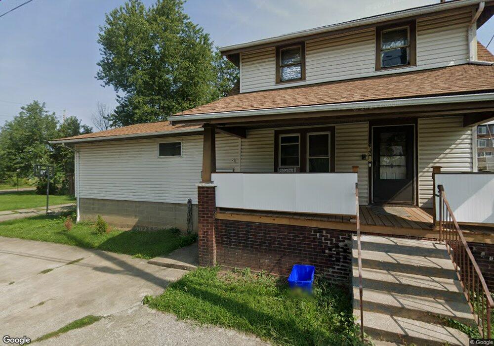
607 Michael Place SW Canton, OH 44707
Southwest Association of Neighbors NeighborhoodEstimated Value: $64,000 - $99,000
3
Beds
2
Baths
1,656
Sq Ft
$51/Sq Ft
Est. Value
About This Home
This home is located at 607 Michael Place SW, Canton, OH 44707 and is currently estimated at $83,931, approximately $50 per square foot. 607 Michael Place SW is a home located in Stark County with nearby schools including Early Learning Center @ Schreiber, Cedar Elementary School, and Clarendon Intermediate School.
Ownership History
Date
Name
Owned For
Owner Type
Purchase Details
Closed on
Mar 5, 2025
Sold by
Patterson Linda P
Bought by
Integrity Family Trust
Current Estimated Value
Purchase Details
Closed on
Mar 4, 2025
Sold by
Patterson Nicole
Bought by
Patterson Linda K
Purchase Details
Closed on
Feb 9, 2006
Sold by
Estate Of Henry A Patterson
Bought by
Patterson Linda K
Create a Home Valuation Report for This Property
The Home Valuation Report is an in-depth analysis detailing your home's value as well as a comparison with similar homes in the area
Home Values in the Area
Average Home Value in this Area
Purchase History
| Date | Buyer | Sale Price | Title Company |
|---|---|---|---|
| Integrity Family Trust | -- | None Listed On Document | |
| Patterson Linda K | -- | None Listed On Document | |
| Patterson Linda K | -- | None Available |
Source: Public Records
Tax History Compared to Growth
Tax History
| Year | Tax Paid | Tax Assessment Tax Assessment Total Assessment is a certain percentage of the fair market value that is determined by local assessors to be the total taxable value of land and additions on the property. | Land | Improvement |
|---|---|---|---|---|
| 2025 | -- | $35,640 | $7,670 | $27,970 |
| 2024 | -- | $35,640 | $7,670 | $27,970 |
| 2023 | $399 | $15,820 | $4,760 | $11,060 |
| 2022 | $415 | $15,820 | $4,760 | $11,060 |
| 2021 | $419 | $15,820 | $4,760 | $11,060 |
| 2020 | $312 | $13,440 | $4,060 | $9,380 |
| 2019 | $273 | $13,450 | $4,070 | $9,380 |
| 2018 | $275 | $13,450 | $4,070 | $9,380 |
| 2017 | $115 | $10,480 | $2,080 | $8,400 |
| 2016 | $115 | $10,480 | $2,080 | $8,400 |
| 2015 | $116 | $10,480 | $2,080 | $8,400 |
| 2014 | $99 | $10,120 | $2,000 | $8,120 |
| 2013 | $50 | $10,120 | $2,000 | $8,120 |
Source: Public Records
Map
Nearby Homes
- 1024 3rd St NW
- 1016 Clinton Ave SW
- 1015 4th St NW
- 1017 Clinton Ave SW
- 1033 Monnot Place NW
- 413 Newton Ave NW
- 719 Prospect Ave SW
- 817 Prospect Ave SW
- 916 6th St NW
- 1334 Margaret Ave SW
- 646 Dueber Ave SW
- 1356 Margaret Ave SW
- 722 High Ave NW
- 633 Park Ave SW
- 202 Lincoln Ave NW
- 1215 Dueber Ave SW
- 1219 Dueber Ave SW
- 905 High Ave NW
- 1405 8th St NW
- 1409 8th St NW
- 707 Wells Ave SW
- 716 High Ave SW
- 601 Raynolds Place SW
- 621 Wells Ave SW
- 622 High Ave SW
- 602 Raynolds Place SW
- 619 Wells Ave SW
- 724 High Ave SW
- 715 Mckinley Ave SW
- 600 George Place SW
- 711 High Ave SW
- 615 Wells Ave SW
- 616 High Ave SW
- 601 Saylor Place SW
- 732 High Ave SW
- 617 Mckinley Ave SW
- 713 Raynolds Place SW
- 729 Mckinley Ave SW
- 515 Saylor Place SW
- 725 High Ave SW