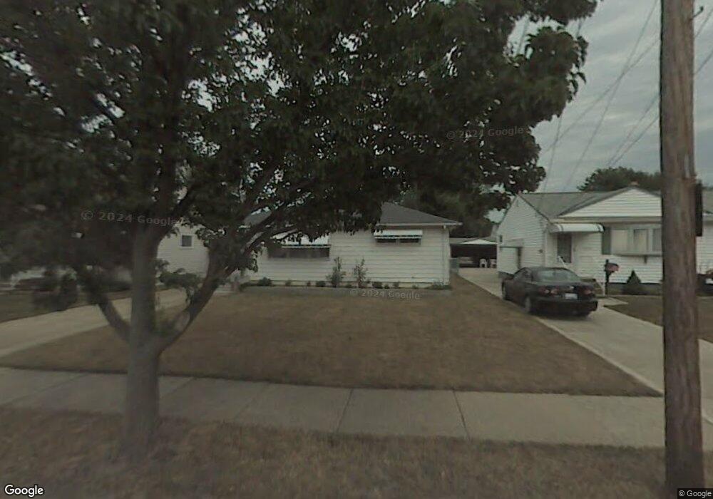
6077 Stark Dr Brookpark, OH 44142
Estimated Value: $175,023 - $249,000
3
Beds
1
Bath
936
Sq Ft
$225/Sq Ft
Est. Value
About This Home
This home is located at 6077 Stark Dr, Brookpark, OH 44142 and is currently estimated at $210,256, approximately $224 per square foot. 6077 Stark Dr is a home located in Cuyahoga County with nearby schools including Berea-Midpark Middle School, Berea-Midpark High School, and Huber Heights Preparatory Academy Parma Academy.
Ownership History
Date
Name
Owned For
Owner Type
Purchase Details
Closed on
Sep 29, 1995
Sold by
Collins Emma Jean
Bought by
Rapacz Tadeusz
Current Estimated Value
Home Financials for this Owner
Home Financials are based on the most recent Mortgage that was taken out on this home.
Original Mortgage
$77,000
Outstanding Balance
$561
Interest Rate
8%
Mortgage Type
New Conventional
Estimated Equity
$209,695
Purchase Details
Closed on
May 11, 1982
Sold by
Collins Robert R
Bought by
Emma Jean Collins
Purchase Details
Closed on
Jan 9, 1979
Sold by
Galati Elaine
Bought by
Collins Robert R
Purchase Details
Closed on
Jan 1, 1975
Bought by
Galati Elaine
Create a Home Valuation Report for This Property
The Home Valuation Report is an in-depth analysis detailing your home's value as well as a comparison with similar homes in the area
Home Values in the Area
Average Home Value in this Area
Purchase History
| Date | Buyer | Sale Price | Title Company |
|---|---|---|---|
| Rapacz Tadeusz | $97,000 | -- | |
| Emma Jean Collins | -- | -- | |
| Collins Robert R | $54,000 | -- | |
| Galati Elaine | -- | -- |
Source: Public Records
Mortgage History
| Date | Status | Borrower | Loan Amount |
|---|---|---|---|
| Open | Rapacz Tadeusz | $77,000 |
Source: Public Records
Tax History
| Year | Tax Paid | Tax Assessment Tax Assessment Total Assessment is a certain percentage of the fair market value that is determined by local assessors to be the total taxable value of land and additions on the property. | Land | Improvement |
|---|---|---|---|---|
| 2024 | $2,773 | $54,985 | $12,425 | $42,560 |
| 2023 | $2,885 | $47,360 | $9,030 | $38,330 |
| 2022 | $2,864 | $47,360 | $9,030 | $38,330 |
| 2021 | $2,848 | $47,360 | $9,030 | $38,330 |
| 2020 | $2,569 | $37,590 | $7,180 | $30,420 |
| 2019 | $2,492 | $107,400 | $20,500 | $86,900 |
| 2018 | $2,368 | $37,590 | $7,180 | $30,420 |
| 2017 | $2,441 | $34,160 | $6,720 | $27,440 |
| 2016 | $2,421 | $34,160 | $6,720 | $27,440 |
| 2015 | $2,272 | $34,160 | $6,720 | $27,440 |
| 2014 | $2,272 | $34,160 | $6,720 | $27,440 |
Source: Public Records
Map
Nearby Homes
- 6131 Hardin Dr
- 6014 Westbrook Dr
- 14024 Donald Dr
- 13874 Heatherwood Dr
- 15472 Meigs Blvd
- 15532 Rademaker Dr
- 5727 Gateway Ln Unit 1203
- 6363 Lockhaven Dr
- 13602 Holland Rd
- 16001 Sylvia Dr
- 16117 Hocking Blvd
- 15497 Hummel Rd
- 15995 Hummel Rd
- 15633 Harrison Dr
- 6333 W 130th St
- 16379 Hummel Rd
- 15504 Roxboro Dr
- 15490 Oakshire Ct
- 6710 Woodruff Ct
- 6040 Slater Dr