Estimated Value: $213,939 - $262,000
5
Beds
2
Baths
2,044
Sq Ft
$113/Sq Ft
Est. Value
About This Home
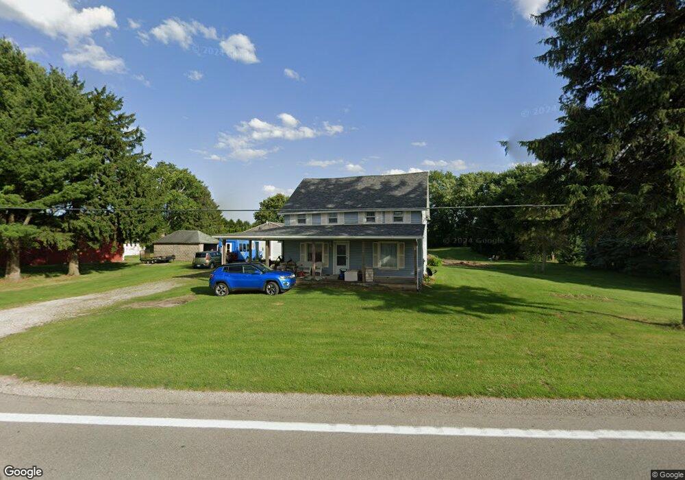
This home is located at 6089 State Route 101 E, Clyde, OH 43410 and is currently estimated at $231,985, approximately $113 per square foot. 6089 State Route 101 E is a home located in Sandusky County with nearby schools including Margaretta Elementary School and Margaretta High School.
Ownership History
Date
Name
Owned For
Owner Type
Purchase Details
Closed on
May 21, 2004
Sold by
Harmon Amelia E
Bought by
Gibson Charles K and Gibson Janice D
Current Estimated Value
Home Financials for this Owner
Home Financials are based on the most recent Mortgage that was taken out on this home.
Original Mortgage
$97,000
Outstanding Balance
$50,367
Interest Rate
7.05%
Mortgage Type
Purchase Money Mortgage
Estimated Equity
$181,618
Create a Home Valuation Report for This Property
The Home Valuation Report is an in-depth analysis detailing your home's value as well as a comparison with similar homes in the area
Purchase History
| Date | Buyer | Sale Price | Title Company |
|---|---|---|---|
| Gibson Charles K | $72,750 | Magee Title Agency Llc |
Source: Public Records
Mortgage History
| Date | Status | Borrower | Loan Amount |
|---|---|---|---|
| Open | Gibson Charles K | $97,000 |
Source: Public Records
Tax History
| Year | Tax Paid | Tax Assessment Tax Assessment Total Assessment is a certain percentage of the fair market value that is determined by local assessors to be the total taxable value of land and additions on the property. | Land | Improvement |
|---|---|---|---|---|
| 2024 | $1,675 | $43,820 | $4,970 | $38,850 |
| 2023 | $1,705 | $34,510 | $3,920 | $30,590 |
| 2022 | $1,474 | $34,510 | $3,920 | $30,590 |
| 2021 | $1,460 | $34,510 | $3,920 | $30,590 |
| 2020 | $1,372 | $30,520 | $3,920 | $26,600 |
| 2019 | $1,375 | $30,520 | $3,920 | $26,600 |
| 2018 | $1,403 | $30,520 | $3,920 | $26,600 |
| 2017 | $1,363 | $28,770 | $3,920 | $24,850 |
| 2016 | $1,332 | $28,770 | $3,920 | $24,850 |
| 2015 | $1,317 | $28,770 | $3,920 | $24,850 |
| 2014 | $1,508 | $30,700 | $4,030 | $26,670 |
| 2013 | $1,462 | $30,700 | $4,030 | $26,670 |
Source: Public Records
Map
Nearby Homes
- 0 312 Unit 10003540
- 1420 County Road 302 Unit 14
- 0 County Rd 260 Rd Unit 5061556
- 1727 E Mcpherson Hwy
- 174 Centennial Dr
- 162 Centennial Dr
- 136 Centennial Dr
- 0 Auxiliary Dr
- 1 Progress Dr
- 103 Progress Dr
- 710 N State Route 510
- 0 Durnwald Dr
- CR 260 89.6 acres Durnwald Dr
- 625 Ames St
- 0 Ames St
- 3850 County Road 231
- 1766 County Road 260 Elm St
- 0 W Mcpherson Hwy
- 1085 W Main St
- 0 County Road 175
- 6111 State Route 101 E
- 6111 State Route 101 E
- 6085 State Route 101 E
- 6080 State Route 101 E
- 6049 Ohio 101
- 6049 State Route 101 E
- 6072 State Route 101 E
- 6029 State Route 101 E
- 5981 State Route 101 E
- 6058 State Route 101 E
- 116 S County Road 294
- 116 N County Road 294
- 6030 State Route 101 E
- 6030 Ohio 101
- 116 C R 294
- 6004 Ohio 101
- 6004 State Route 101 E
- 110 N County Road 294
- 5979 State Route 101 E
- 6191 State Route 101 E
Your Personal Tour Guide
Ask me questions while you tour the home.