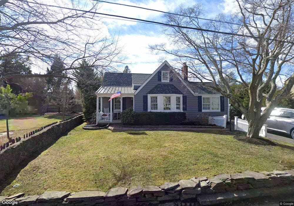
609 Locust Rd Brielle, NJ 08730
Estimated Value: $980,955 - $1,530,000
3
Beds
3
Baths
1,748
Sq Ft
$690/Sq Ft
Est. Value
About This Home
This home is located at 609 Locust Rd, Brielle, NJ 08730 and is currently estimated at $1,206,489, approximately $690 per square foot. 609 Locust Rd is a home located in Monmouth County with nearby schools including Brielle Elementary School and St. Peter School.
Ownership History
Date
Name
Owned For
Owner Type
Purchase Details
Closed on
Oct 4, 2010
Sold by
Young Darlene
Bought by
Blessing Cornelius T and Blessing Jane P
Current Estimated Value
Home Financials for this Owner
Home Financials are based on the most recent Mortgage that was taken out on this home.
Original Mortgage
$171,000
Outstanding Balance
$1,253
Interest Rate
3.91%
Mortgage Type
New Conventional
Estimated Equity
$1,205,236
Purchase Details
Closed on
Feb 19, 2002
Sold by
Carrino Joseph
Bought by
Giroux Susan
Purchase Details
Closed on
Jan 4, 2000
Sold by
Miller Georgia
Bought by
Carrino Joseph and Carrino Corrine
Home Financials for this Owner
Home Financials are based on the most recent Mortgage that was taken out on this home.
Original Mortgage
$216,000
Interest Rate
7.83%
Create a Home Valuation Report for This Property
The Home Valuation Report is an in-depth analysis detailing your home's value as well as a comparison with similar homes in the area
Home Values in the Area
Average Home Value in this Area
Purchase History
| Date | Buyer | Sale Price | Title Company |
|---|---|---|---|
| Blessing Cornelius T | $550,000 | Old Republic National Title | |
| Giroux Susan | $345,000 | -- | |
| Carrino Joseph | $270,000 | -- |
Source: Public Records
Mortgage History
| Date | Status | Borrower | Loan Amount |
|---|---|---|---|
| Open | Blessing Cornelius T | $171,000 | |
| Previous Owner | Carrino Joseph | $216,000 |
Source: Public Records
Tax History Compared to Growth
Tax History
| Year | Tax Paid | Tax Assessment Tax Assessment Total Assessment is a certain percentage of the fair market value that is determined by local assessors to be the total taxable value of land and additions on the property. | Land | Improvement |
|---|---|---|---|---|
| 2025 | $9,687 | $899,900 | $604,500 | $295,400 |
| 2024 | $9,116 | $780,600 | $493,500 | $287,100 |
| 2023 | $9,116 | $709,400 | $436,000 | $273,400 |
| 2022 | $8,741 | $671,300 | $411,000 | $260,300 |
| 2021 | $8,741 | $586,600 | $361,000 | $225,600 |
| 2020 | $8,463 | $517,000 | $311,000 | $206,000 |
| 2019 | $7,917 | $490,800 | $286,000 | $204,800 |
| 2018 | $7,771 | $475,600 | $286,000 | $189,600 |
| 2017 | $7,772 | $469,900 | $286,000 | $183,900 |
| 2016 | $7,680 | $465,200 | $286,000 | $179,200 |
| 2015 | $7,352 | $457,100 | $286,000 | $171,100 |
| 2014 | $8,319 | $550,000 | $450,000 | $100,000 |
Source: Public Records
Map
Nearby Homes
- 806 Riverview Dr
- 406 Brown St
- 642 Rankin Rd
- 816 Rathjen Rd
- 846 William Dr
- 508 Harris Ave
- 20 Maple Ln Unit D
- 300 Union Ave
- 29 Mulberry Ct Unit D
- 542 Woodland Ave
- 41 Poplar Ct Unit C
- 308 South St
- 619 Park Ave
- 323-325 Fisk Ave
- 907 Riverview Dr
- 329 Fisk Ave
- 507 Magnolia Ave
- 610 Agnes Ave
- Kensington Plan at The Monmouth - The Villas 55+
- 204 Curtis Ave
- 611 Locust Rd
- 612 Cherokee Ln
- 614 Cherokee Ln
- 608 Locust Rd
- 610 Cherokee Ln
- 605 Locust Rd
- 618 Cherokee Ln
- 606 Locust Rd
- 610 Locust Rd
- 613 Locust Rd
- 613 Cherokee Ln
- 611 Cherokee Ln
- 603 Sandy Ct
- 615 Cherokee Ln
- 604 Locust Rd
- 609 Cherokee Ln
- 604 Cherokee Ln
- 604 Cherokee Ln Unit Summer Weekly
- 604 Cherokee Ln Unit Weekly
- 604 Cherokee Ln Unit WINTER