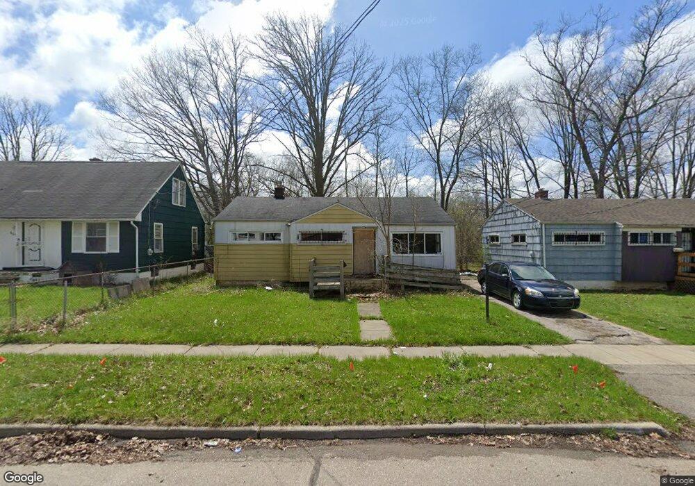
609 W Austin Ave Flint, MI 48505
MLK Circle NeighborhoodEstimated Value: $47,000 - $53,000
3
Beds
1
Bath
920
Sq Ft
$54/Sq Ft
Est. Value
About This Home
This home is located at 609 W Austin Ave, Flint, MI 48505 and is currently estimated at $50,000, approximately $54 per square foot. 609 W Austin Ave is a home located in Genesee County with nearby schools including Brownell STEM Academy, The New Standard Academy, and Eagle's Nest Academy.
Ownership History
Date
Name
Owned For
Owner Type
Purchase Details
Closed on
Dec 19, 2019
Sold by
Cherry Deborah L
Bought by
County Land Bank Authority
Current Estimated Value
Purchase Details
Closed on
Jun 20, 2014
Sold by
The Genesee County Land Bank Authority
Bought by
Randall Tawanna
Purchase Details
Closed on
Dec 20, 2013
Sold by
Genesee County Treasurer
Bought by
Genesee County Land Bank
Purchase Details
Closed on
Oct 5, 2012
Sold by
Terrell Addie
Bought by
Spartan Equities High Yield Fund I Llc
Create a Home Valuation Report for This Property
The Home Valuation Report is an in-depth analysis detailing your home's value as well as a comparison with similar homes in the area
Home Values in the Area
Average Home Value in this Area
Purchase History
| Date | Buyer | Sale Price | Title Company |
|---|---|---|---|
| County Land Bank Authority | -- | None Available | |
| Randall Tawanna | $3,842 | None Available | |
| Genesee County Land Bank | -- | None Available | |
| Spartan Equities High Yield Fund I Llc | -- | None Available |
Source: Public Records
Mortgage History
| Date | Status | Borrower | Loan Amount |
|---|---|---|---|
| Closed | Randall Tawanna | $0 |
Source: Public Records
Tax History Compared to Growth
Tax History
| Year | Tax Paid | Tax Assessment Tax Assessment Total Assessment is a certain percentage of the fair market value that is determined by local assessors to be the total taxable value of land and additions on the property. | Land | Improvement |
|---|---|---|---|---|
| 2025 | -- | $0 | $0 | $0 |
| 2024 | -- | $0 | $0 | $0 |
| 2023 | -- | $0 | $0 | $0 |
| 2022 | $0 | $0 | $0 | $0 |
| 2021 | $0 | $0 | $0 | $0 |
| 2020 | $268 | $0 | $0 | $0 |
| 2019 | $491 | $4,700 | $0 | $0 |
| 2018 | $878 | $5,700 | $0 | $0 |
| 2017 | $685 | $0 | $0 | $0 |
| 2016 | $334 | $0 | $0 | $0 |
| 2015 | -- | $0 | $0 | $0 |
| 2014 | -- | $0 | $0 | $0 |
| 2012 | -- | $9,100 | $0 | $0 |
Source: Public Records
Map
Nearby Homes
- 610 W Austin Ave
- 618 W Austin Ave
- 505 W Ruth Ave
- 536 W Home Ave
- 605 W Foss Ave
- 613 W Foss Ave
- 405 W Lorado Ave
- 617 W Holbrook Ave
- 614 W Holbrook Ave
- 6610 Cranwood Dr
- 402 W Gracelawn Ave
- 6702 Cranwood Dr
- 5714 Suburban Ct
- 525 W Bundy Ave
- 5610 Baldwin Blvd
- 405 W Bundy Ave
- 6914 Daryll Dr
- 225 E Piper Ave
- 6902 Sally Ct
- 5318 Baldwin Blvd
- 605 W Austin Ave
- 601 W Austin Ave
- 613 W Austin Ave
- 6201 College St
- 621 W Austin Ave
- 614 W Austin Ave
- 606 W Austin Ave
- 602 W Austin Ave
- 625 W Austin Ave
- 622 W Austin Ave
- 629 W Austin Ave
- 626 W Austin Ave
- 526 W Austin Ave
- 609 W Ruth Ave
- 521 W Austin Ave
- 525 W Austin Ave
- 613 W Ruth Ave
- 605 W Ruth Ave
- 601 W Ruth Ave
- 630 W Austin Ave