Estimated Value: $735,726 - $785,000
--
Bed
--
Bath
1,983
Sq Ft
$380/Sq Ft
Est. Value
About This Home
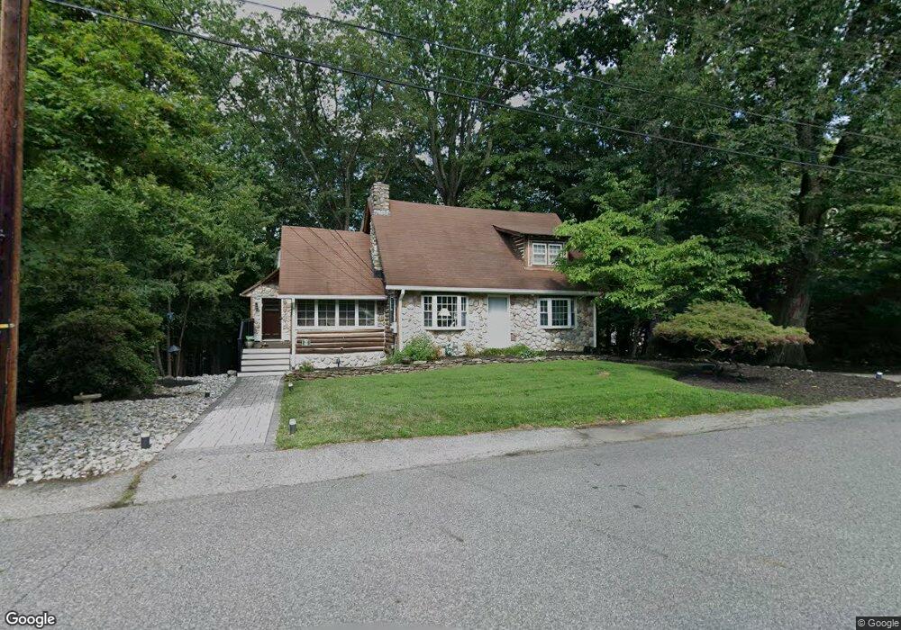
This home is located at 61 Balsam Rd, Wayne, NJ 07470 and is currently estimated at $753,432, approximately $379 per square foot. 61 Balsam Rd is a home located in Passaic County with nearby schools including Pines Lake Elementary School, Schuyler-Colfax Middle School, and Wayne Hills High School.
Ownership History
Date
Name
Owned For
Owner Type
Purchase Details
Closed on
Jul 1, 2021
Sold by
Obringer Sandra L
Bought by
Obringer Robert W
Current Estimated Value
Purchase Details
Closed on
Jun 26, 2019
Sold by
Petrick Joseph S and Obringer Lynn
Bought by
Obringer Robert W and Obringer Sandra L
Home Financials for this Owner
Home Financials are based on the most recent Mortgage that was taken out on this home.
Original Mortgage
$388,000
Interest Rate
3.9%
Mortgage Type
New Conventional
Purchase Details
Closed on
May 5, 2005
Sold by
Meirowitz Marvin
Bought by
Petrick Joseph S and Obringer Lynn
Home Financials for this Owner
Home Financials are based on the most recent Mortgage that was taken out on this home.
Original Mortgage
$424,000
Interest Rate
5.79%
Purchase Details
Closed on
Mar 8, 2000
Sold by
Meirowitz Marvin and Meirowitz Elizabeth
Bought by
Meirowitz Marvin and Meirowitz Elizabeth
Create a Home Valuation Report for This Property
The Home Valuation Report is an in-depth analysis detailing your home's value as well as a comparison with similar homes in the area
Home Values in the Area
Average Home Value in this Area
Purchase History
| Date | Buyer | Sale Price | Title Company |
|---|---|---|---|
| Obringer Robert W | -- | None Available | |
| Obringer Robert W | -- | Walker Michael | |
| Obringer Robert W | $485,000 | Kenworth Title Llc | |
| Petrick Joseph S | $530,000 | -- | |
| Meirowitz Marvin | -- | -- |
Source: Public Records
Mortgage History
| Date | Status | Borrower | Loan Amount |
|---|---|---|---|
| Previous Owner | Obringer Robert W | $388,000 | |
| Previous Owner | Petrick Joseph S | $424,000 |
Source: Public Records
Tax History Compared to Growth
Tax History
| Year | Tax Paid | Tax Assessment Tax Assessment Total Assessment is a certain percentage of the fair market value that is determined by local assessors to be the total taxable value of land and additions on the property. | Land | Improvement |
|---|---|---|---|---|
| 2025 | $12,469 | $209,700 | $123,800 | $85,900 |
| 2024 | $11,991 | $209,700 | $123,800 | $85,900 |
| 2022 | $11,856 | $209,700 | $123,800 | $85,900 |
| 2021 | $11,844 | $209,700 | $123,800 | $85,900 |
| 2020 | $11,791 | $209,700 | $123,800 | $85,900 |
| 2019 | $11,563 | $209,700 | $123,800 | $85,900 |
| 2018 | $11,460 | $209,700 | $123,800 | $85,900 |
| 2017 | $11,355 | $209,700 | $123,800 | $85,900 |
| 2016 | $11,196 | $209,700 | $123,800 | $85,900 |
| 2015 | $11,062 | $209,700 | $123,800 | $85,900 |
| 2014 | $10,749 | $209,700 | $123,800 | $85,900 |
Source: Public Records
Map
Nearby Homes
- 53 Balsam Rd
- 69 Balsam Rd
- 380 Pines Lake Dr E
- 43 Balsam Rd
- 77 Balsam Rd
- 60 Balsam Rd
- 394 Pines Lake Dr E
- 68 Balsam Rd
- 390 Pines Lake Dr E
- 81 Balsam Rd
- 48 Balsam Rd
- 76 Balsam Rd
- 402 Pines Lake Dr E
- 370 Pines Lake Dr E
- 42 Balsam Rd
- 80 Balsam Rd
- 37 Balsam Rd
- 89 Balsam Rd
- 36 Balsam Rd
- 408 Pines Lake Dr E