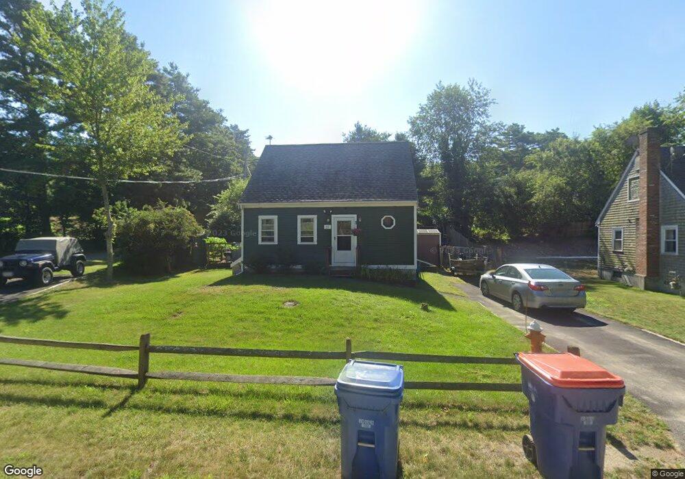
61 Birch St Plymouth, MA 02360
Estimated Value: $443,000 - $461,000
3
Beds
2
Baths
978
Sq Ft
$459/Sq Ft
Est. Value
About This Home
This home is located at 61 Birch St, Plymouth, MA 02360 and is currently estimated at $448,419, approximately $458 per square foot. 61 Birch St is a home located in Plymouth County with nearby schools including South Elementary School, Plymouth South Middle School, and Plymouth South High School.
Ownership History
Date
Name
Owned For
Owner Type
Purchase Details
Closed on
Jan 5, 1996
Sold by
Fnma
Bought by
Ryan Richard T and Ryan Juliana T
Current Estimated Value
Purchase Details
Closed on
Sep 26, 1995
Sold by
Peterson Mark W
Bought by
Federal National Mortgage Association
Purchase Details
Closed on
Sep 19, 1988
Sold by
Plymouth Baly Rt 53
Bought by
Peterson Mark W
Purchase Details
Closed on
May 12, 1988
Sold by
Case Robert R
Bought by
Plymouth Bay Rt 53
Create a Home Valuation Report for This Property
The Home Valuation Report is an in-depth analysis detailing your home's value as well as a comparison with similar homes in the area
Home Values in the Area
Average Home Value in this Area
Purchase History
| Date | Buyer | Sale Price | Title Company |
|---|---|---|---|
| Ryan Richard T | $86,380 | -- | |
| Federal National Mortgage Association | $87,000 | -- | |
| Peterson Mark W | $115,900 | -- | |
| Plymouth Bay Rt 53 | $36,000 | -- |
Source: Public Records
Mortgage History
| Date | Status | Borrower | Loan Amount |
|---|---|---|---|
| Open | Plymouth Bay Rt 53 | $100,000 | |
| Closed | Plymouth Bay Rt 53 | $100,000 | |
| Closed | Plymouth Bay Rt 53 | $70,000 |
Source: Public Records
Tax History Compared to Growth
Tax History
| Year | Tax Paid | Tax Assessment Tax Assessment Total Assessment is a certain percentage of the fair market value that is determined by local assessors to be the total taxable value of land and additions on the property. | Land | Improvement |
|---|---|---|---|---|
| 2025 | $4,693 | $369,800 | $167,000 | $202,800 |
| 2024 | $4,633 | $360,000 | $163,500 | $196,500 |
| 2023 | $4,464 | $325,600 | $142,800 | $182,800 |
| 2022 | $4,107 | $266,200 | $129,800 | $136,400 |
| 2021 | $3,961 | $245,100 | $129,800 | $115,300 |
| 2020 | $3,725 | $227,800 | $113,700 | $114,100 |
| 2019 | $3,578 | $216,300 | $101,200 | $115,100 |
| 2018 | $3,432 | $208,500 | $93,500 | $115,000 |
| 2017 | $3,231 | $194,900 | $93,500 | $101,400 |
| 2016 | $2,982 | $183,300 | $80,900 | $102,400 |
| 2015 | $2,937 | $189,000 | $85,700 | $103,300 |
| 2014 | $2,885 | $190,700 | $90,400 | $100,300 |
Source: Public Records
Map
Nearby Homes
- 47 Lake Dr
- 110 Packard St
- 19 Milford St
- 901 Head of The Bay Rd
- 14 Buttonwood Ln
- 15 Downey St
- 23 Pine Ridge Rd
- 11 Thompson Rd Unit 11A
- 11 Thompson Rd Unit A
- 27 Baker Ln Unit 27
- 810 Head of The Bay Rd
- 32 Rickey Ln
- 8 Cabot Cir
- 83 Red Brook Rd
- 73 Lewis Point Rd
- 74 Martin St
- 65 Lewis Point Rd
- 0 Lewis Point Rd
- 272 Glen Charlie Rd
- 43 Butler St
- 57 Birch St
- 60 Nickerson St
- 58 Nickerson St
- 64 Nickerson St
- 64 Nickerson St
- 56 Nickerson St
- 16 Worcester St
- 64 Birch St
- 64 Birch St Unit 1
- 70 Birch St
- 19 Worcester St
- 54 Nickerson St
- 57 Nickerson St
- 54 Birch St
- 52 Nickerson St
- 53 Birch St
- 68 Birch St
- 18 Worcester St Unit 1
- 18 Worcester St
- 70 Nickerson St