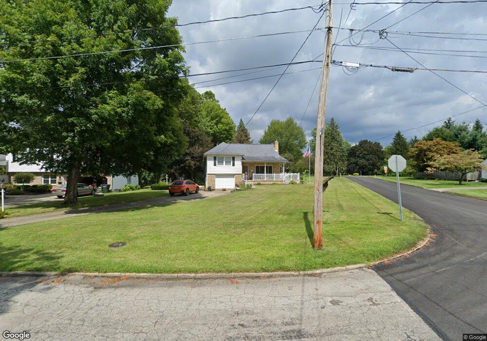
61 Duncan Dr Youngstown, OH 44514
Estimated Value: $244,522 - $271,000
3
Beds
2
Baths
1,682
Sq Ft
$153/Sq Ft
Est. Value
About This Home
This home is located at 61 Duncan Dr, Youngstown, OH 44514 and is currently estimated at $256,881, approximately $152 per square foot. 61 Duncan Dr is a home located in Mahoning County with nearby schools including Poland Union Elementary School, Poland Middle School, and Poland Seminary High School.
Ownership History
Date
Name
Owned For
Owner Type
Purchase Details
Closed on
Oct 20, 2020
Sold by
Kaenga Shannon Lee and Laughner Shannon
Bought by
Kacenga Stephen Gordon
Current Estimated Value
Purchase Details
Closed on
Oct 21, 2005
Sold by
Deley Patrice and Deley Ronald A
Bought by
Laughner Shannon
Home Financials for this Owner
Home Financials are based on the most recent Mortgage that was taken out on this home.
Original Mortgage
$109,250
Outstanding Balance
$58,623
Interest Rate
5.8%
Mortgage Type
Fannie Mae Freddie Mac
Estimated Equity
$198,258
Create a Home Valuation Report for This Property
The Home Valuation Report is an in-depth analysis detailing your home's value as well as a comparison with similar homes in the area
Home Values in the Area
Average Home Value in this Area
Purchase History
| Date | Buyer | Sale Price | Title Company |
|---|---|---|---|
| Kacenga Stephen Gordon | -- | None Available | |
| Laughner Shannon | $115,000 | -- |
Source: Public Records
Mortgage History
| Date | Status | Borrower | Loan Amount |
|---|---|---|---|
| Open | Laughner Shannon | $109,250 |
Source: Public Records
Tax History Compared to Growth
Tax History
| Year | Tax Paid | Tax Assessment Tax Assessment Total Assessment is a certain percentage of the fair market value that is determined by local assessors to be the total taxable value of land and additions on the property. | Land | Improvement |
|---|---|---|---|---|
| 2024 | $3,606 | $67,050 | $11,600 | $55,450 |
| 2023 | $3,565 | $67,050 | $11,600 | $55,450 |
| 2022 | $2,700 | $44,530 | $11,600 | $32,930 |
| 2021 | $2,582 | $44,530 | $11,600 | $32,930 |
| 2020 | $2,593 | $44,530 | $11,600 | $32,930 |
| 2019 | $2,343 | $37,330 | $11,600 | $25,730 |
| 2018 | $2,270 | $37,330 | $11,600 | $25,730 |
| 2017 | $2,345 | $37,330 | $11,600 | $25,730 |
| 2016 | $2,422 | $37,940 | $11,600 | $26,340 |
| 2015 | $2,299 | $37,940 | $11,600 | $26,340 |
| 2014 | $2,307 | $37,940 | $11,600 | $26,340 |
| 2013 | $2,278 | $37,940 | $11,600 | $26,340 |
Source: Public Records
Map
Nearby Homes
- 6074 Frontier Dr
- 2721 Algonquin Dr
- 2379 Clyde St
- 2667 Center Rd
- 154 Rocky Ledge Dr
- 2295 Bel Aire Ln
- 2856 Heatherbrae Dr
- 5838 Poland Struthers Rd
- 2831 Center Rd
- 2959 Algonquin Dr
- 2985 Algonquin Dr
- 20 Nesbitt St
- 2307 Hamilton Ave
- 43 Venloe Dr
- 0 Clingan Rd Unit 4461196
- 2959 Holyoke Dr
- 34 Venloe Dr
- 6137 Acatello Place
- 3151 Heatherbrae Dr
- 2411 Lyon Blvd