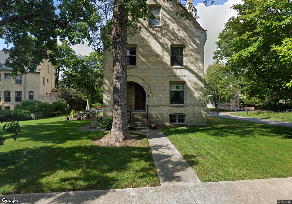
61 Scott Loop Highland Park, IL 60035
West Highland Park NeighborhoodEstimated Value: $1,093,949 - $1,364,000
5
Beds
4
Baths
3,808
Sq Ft
$331/Sq Ft
Est. Value
About This Home
This home is located at 61 Scott Loop, Highland Park, IL 60035 and is currently estimated at $1,261,487, approximately $331 per square foot. 61 Scott Loop is a home located in Lake County with nearby schools including Wayne Thomas Elementary School, Northwood Jr High School, and Highland Park High School.
Ownership History
Date
Name
Owned For
Owner Type
Purchase Details
Closed on
Aug 19, 1998
Sold by
Tfs Operating Company Llc
Bought by
Schorsch Martin B and Schorsch Twila L
Current Estimated Value
Home Financials for this Owner
Home Financials are based on the most recent Mortgage that was taken out on this home.
Original Mortgage
$266,250
Outstanding Balance
$55,303
Interest Rate
6.87%
Estimated Equity
$1,206,184
Create a Home Valuation Report for This Property
The Home Valuation Report is an in-depth analysis detailing your home's value as well as a comparison with similar homes in the area
Home Values in the Area
Average Home Value in this Area
Purchase History
| Date | Buyer | Sale Price | Title Company |
|---|---|---|---|
| Schorsch Martin B | $355,000 | -- |
Source: Public Records
Mortgage History
| Date | Status | Borrower | Loan Amount |
|---|---|---|---|
| Open | Schorsch Martin B | $266,250 |
Source: Public Records
Tax History
| Year | Tax Paid | Tax Assessment Tax Assessment Total Assessment is a certain percentage of the fair market value that is determined by local assessors to be the total taxable value of land and additions on the property. | Land | Improvement |
|---|---|---|---|---|
| 2024 | $26,757 | $347,253 | $52,506 | $294,747 |
| 2023 | $26,757 | $313,009 | $47,328 | $265,681 |
| 2022 | $27,111 | $307,056 | $51,992 | $255,064 |
| 2021 | $24,996 | $296,816 | $50,258 | $246,558 |
| 2020 | $24,187 | $296,816 | $50,258 | $246,558 |
| 2019 | $23,371 | $295,428 | $50,023 | $245,405 |
| 2018 | $22,003 | $294,793 | $58,186 | $236,607 |
| 2017 | $21,659 | $293,093 | $57,850 | $235,243 |
| 2016 | $21,961 | $293,092 | $55,074 | $238,018 |
| 2015 | $21,292 | $272,315 | $51,170 | $221,145 |
| 2014 | $19,518 | $244,354 | $57,162 | $187,192 |
| 2012 | $18,981 | $245,779 | $57,495 | $188,284 |
Source: Public Records
Map
Nearby Homes
- 34 Logan Loop Unit 242
- 3481 Bradley Ct
- 44 Westover Rd
- 595 Circle Ln
- 0 Patten Rd
- 3373 Brook Rd
- 512 Hill St
- 3272 Western Ave
- 912 Morningside Dr
- 308 Washington Ave
- 535 Lockard Ln
- 525 Lockard Ln
- 43 Clay Ave
- 786 Hill St
- 239 Sheridan Ave
- 890 Cherokee Rd
- 225 Burchell Ave
- 719 Burchell Ave
- 840 Auburn Ct
- 417 Temple Ave
- 68 Macarthur Loop
- 51 Scott Loop
- 58 Macarthur Loop
- 50 Macarthur Loop
- 47 Scott Loop
- 46 Macarthur Loop
- 3693 Leonard Wood E
- 59 Macarthur Loop
- 41 Scott Loop
- 46 Scott Loop
- 69 Macarthur Loop
- 51 Macarthur Loop
- 77 Macarthur Loop
- 36 Macarthur Loop
- 3687 Leonard Wood E
- 3687 Leonard Wood E
- 40 Scott Loop
- 33 Scott Loop
- 3673 Leonard Wood E
- 85 Leonard Wood N
Your Personal Tour Guide
Ask me questions while you tour the home.