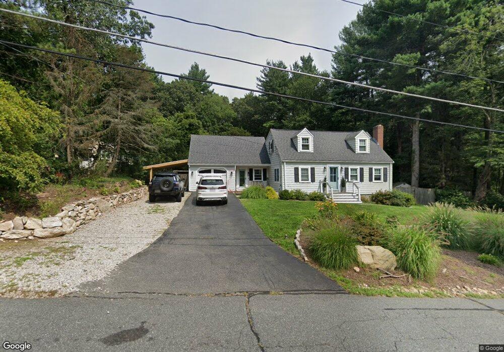
61 Strobus Ln Ashland, MA 01721
Estimated Value: $803,000 - $939,000
3
Beds
4
Baths
2,752
Sq Ft
$312/Sq Ft
Est. Value
About This Home
This home is located at 61 Strobus Ln, Ashland, MA 01721 and is currently estimated at $859,004, approximately $312 per square foot. 61 Strobus Ln is a home located in Middlesex County with nearby schools including William Pittaway Elementary School, David Mindess Elementary School, and Henry E. Warren Elementary School.
Ownership History
Date
Name
Owned For
Owner Type
Purchase Details
Closed on
Mar 30, 1992
Sold by
Martin James F and Martin Joan M
Bought by
Bronstein Stephen A and Bronstein Susanne K
Current Estimated Value
Create a Home Valuation Report for This Property
The Home Valuation Report is an in-depth analysis detailing your home's value as well as a comparison with similar homes in the area
Home Values in the Area
Average Home Value in this Area
Purchase History
| Date | Buyer | Sale Price | Title Company |
|---|---|---|---|
| Bronstein Stephen A | $184,500 | -- | |
| Bronstein Stephen A | $184,500 | -- |
Source: Public Records
Mortgage History
| Date | Status | Borrower | Loan Amount |
|---|---|---|---|
| Open | Bronstein Stephen A | $217,000 | |
| Closed | Bronstein Stephen A | $21,900 | |
| Closed | Bronstein Stephen A | $140,000 |
Source: Public Records
Tax History Compared to Growth
Tax History
| Year | Tax Paid | Tax Assessment Tax Assessment Total Assessment is a certain percentage of the fair market value that is determined by local assessors to be the total taxable value of land and additions on the property. | Land | Improvement |
|---|---|---|---|---|
| 2025 | $8,590 | $672,700 | $266,500 | $406,200 |
| 2024 | $8,450 | $638,200 | $266,500 | $371,700 |
| 2023 | $7,786 | $565,400 | $253,900 | $311,500 |
| 2022 | $7,884 | $496,500 | $230,700 | $265,800 |
| 2021 | $7,371 | $462,700 | $230,700 | $232,000 |
| 2020 | $7,130 | $441,200 | $230,700 | $210,500 |
| 2019 | $6,903 | $424,000 | $230,700 | $193,300 |
| 2018 | $6,619 | $398,500 | $228,500 | $170,000 |
| 2017 | $6,541 | $391,700 | $228,500 | $163,200 |
| 2016 | $6,239 | $367,000 | $225,500 | $141,500 |
| 2015 | $5,875 | $339,600 | $212,600 | $127,000 |
| 2014 | $5,871 | $337,600 | $188,600 | $149,000 |
Source: Public Records
Map
Nearby Homes
- 3 Blueberry Hill Ln
- 203 Pleasant St
- 0 Ballard Highland Marietta Unit 73391306
- 34 Jodie Rd
- 0 Oregon Rd
- 10 Foothill Rd
- 116 Waverly St
- 13 Clark St
- 327 Singletary Ln
- The Majesty Plan at Constitution Village
- The Alexander Plan at Constitution Village
- The Countess Plan at Constitution Village
- Jasmine Glory Plan at Constitution Village
- 15 Bellmore Rd
- 0 Oak St
- 8 Bellmore Rd
- 0 Cordaville Rd
- 11 Voyagers Ln
- 1550 Worcester Rd Unit 101
- 1500 Worcester Rd Unit 221