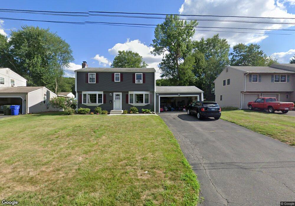
61 Whitewood Rd Newington, CT 06111
Estimated Value: $406,000 - $466,000
4
Beds
2
Baths
1,598
Sq Ft
$269/Sq Ft
Est. Value
About This Home
This home is located at 61 Whitewood Rd, Newington, CT 06111 and is currently estimated at $429,722, approximately $268 per square foot. 61 Whitewood Rd is a home located in Hartford County with nearby schools including Elizabeth Green School, Martin Kellogg Middle School, and Newington High School.
Ownership History
Date
Name
Owned For
Owner Type
Purchase Details
Closed on
Sep 26, 2012
Sold by
Walsh Joseph
Bought by
Calado Sabrina
Current Estimated Value
Home Financials for this Owner
Home Financials are based on the most recent Mortgage that was taken out on this home.
Original Mortgage
$210,500
Outstanding Balance
$146,518
Interest Rate
3.62%
Estimated Equity
$283,204
Purchase Details
Closed on
Apr 2, 2007
Sold by
Knight Tr Constance E and Knight Constance E
Bought by
Calado Sabrina and Walsh Joseph
Home Financials for this Owner
Home Financials are based on the most recent Mortgage that was taken out on this home.
Original Mortgage
$220,000
Interest Rate
6.33%
Create a Home Valuation Report for This Property
The Home Valuation Report is an in-depth analysis detailing your home's value as well as a comparison with similar homes in the area
Home Values in the Area
Average Home Value in this Area
Purchase History
| Date | Buyer | Sale Price | Title Company |
|---|---|---|---|
| Calado Sabrina | -- | -- | |
| Calado Sabrina | $275,000 | -- |
Source: Public Records
Mortgage History
| Date | Status | Borrower | Loan Amount |
|---|---|---|---|
| Open | Calado Sabrina | $210,500 | |
| Previous Owner | Calado Sabrina | $220,000 | |
| Previous Owner | Calado Sabrina | $17,500 | |
| Previous Owner | Calado Sabrina | $212,000 |
Source: Public Records
Tax History Compared to Growth
Tax History
| Year | Tax Paid | Tax Assessment Tax Assessment Total Assessment is a certain percentage of the fair market value that is determined by local assessors to be the total taxable value of land and additions on the property. | Land | Improvement |
|---|---|---|---|---|
| 2024 | $6,304 | $158,910 | $54,050 | $104,860 |
| 2023 | $6,096 | $158,910 | $54,050 | $104,860 |
| 2022 | $6,116 | $158,910 | $54,050 | $104,860 |
| 2021 | $6,167 | $158,910 | $54,050 | $104,860 |
| 2020 | $6,045 | $153,900 | $51,970 | $101,930 |
| 2019 | $6,071 | $153,900 | $51,970 | $101,930 |
| 2018 | $5,925 | $153,900 | $51,970 | $101,930 |
| 2017 | $5,631 | $153,900 | $51,970 | $101,930 |
| 2016 | $5,502 | $153,900 | $51,970 | $101,930 |
| 2014 | $5,515 | $158,620 | $52,320 | $106,300 |
Source: Public Records
Map
Nearby Homes
- 249 Connecticut Ave
- 20 Dogwood Ln
- 37 Commonwealth Ave
- 193 Connecticut Ave
- 377 Connecticut Ave
- 405 Connecticut Ave
- 46 Millbrook Ct Unit 46
- 28 Kirkham St
- 68 Piper Brook Ave
- 70 Cedar Ridge Rd
- 27 Harding Ave
- 35 Tinsmith Crossing Unit 35
- 35 Harding Ave
- 38 Potter Crossing
- 846 Main St
- 263 Williamstown Ct
- 73 Camp Ave
- 105 Gilbert Rd
- 57 Welles Dr
- 140 Camp Ave
- 67 Whitewood Rd
- 55 Whitewood Rd
- 49 Whitewood Rd
- 78 Augusta Dr
- 73 Whitewood Rd
- 84 Augusta Dr
- 72 Augusta Dr
- 43 Whitewood Rd
- 58 Whitewood Rd
- 79 Whitewood Rd
- 64 Whitewood Rd
- 90 Augusta Dr
- 66 Augusta Dr
- 52 Whitewood Rd
- 70 Whitewood Rd
- 46 Whitewood Rd
- 76 Whitewood Rd
- 98 Augusta Dr
- 58 Augusta Dr
- 37 Whitewood Rd