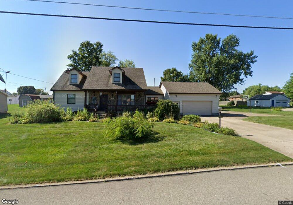
610 Brandon Ave Struthers, OH 44471
Estimated Value: $133,000 - $189,000
2
Beds
2
Baths
1,196
Sq Ft
$137/Sq Ft
Est. Value
About This Home
This home is located at 610 Brandon Ave, Struthers, OH 44471 and is currently estimated at $163,378, approximately $136 per square foot. 610 Brandon Ave is a home located in Mahoning County with nearby schools including Mckamy Elementary School, Carrollton Elementary School, and Lovett Elementary School.
Ownership History
Date
Name
Owned For
Owner Type
Purchase Details
Closed on
Jul 15, 2022
Bought by
Miller Catherine C
Current Estimated Value
Purchase Details
Closed on
Jul 11, 2022
Sold by
Miller Catherine C
Bought by
Miller Catherine C and Miller Bradley D
Purchase Details
Closed on
Dec 1, 2020
Sold by
Estate Of Doreen Cercone
Bought by
Miller Catherine C
Purchase Details
Closed on
Jul 18, 1979
Bought by
Cercone Sam and Cercone Doreen
Create a Home Valuation Report for This Property
The Home Valuation Report is an in-depth analysis detailing your home's value as well as a comparison with similar homes in the area
Home Values in the Area
Average Home Value in this Area
Purchase History
| Date | Buyer | Sale Price | Title Company |
|---|---|---|---|
| Miller Catherine C | -- | -- | |
| Miller Catherine C | -- | None Listed On Document | |
| Miller Catherine C | -- | None Available | |
| Cercone Sam | -- | -- |
Source: Public Records
Tax History Compared to Growth
Tax History
| Year | Tax Paid | Tax Assessment Tax Assessment Total Assessment is a certain percentage of the fair market value that is determined by local assessors to be the total taxable value of land and additions on the property. | Land | Improvement |
|---|---|---|---|---|
| 2024 | $2,027 | $48,710 | $3,330 | $45,380 |
| 2023 | $1,993 | $48,710 | $3,330 | $45,380 |
| 2022 | $1,984 | $36,710 | $3,130 | $33,580 |
| 2021 | $1,965 | $36,710 | $3,130 | $33,580 |
| 2020 | $1,974 | $36,710 | $3,130 | $33,580 |
| 2019 | $1,889 | $31,920 | $2,720 | $29,200 |
| 2018 | $1,802 | $31,920 | $2,720 | $29,200 |
| 2017 | $1,760 | $31,920 | $2,720 | $29,200 |
| 2016 | $1,720 | $31,220 | $3,170 | $28,050 |
| 2015 | $1,680 | $31,220 | $3,170 | $28,050 |
| 2014 | $1,686 | $31,220 | $3,170 | $28,050 |
| 2013 | $1,566 | $31,220 | $3,170 | $28,050 |
Source: Public Records
Map
Nearby Homes
- 576 W Harvey St
- 550 Brandon Ave
- 525 W Omar St
- 1933 Brandon Ave
- 478 W Harvey St
- 2089 Shetland Ln
- 2021 Country Club Ave
- 1919 Wingate Rd
- 5710 Youngstown Poland Rd
- 2296 Knollwood Ave
- 1913 Country Club Ave
- 418 W Wilson St
- 2128 Lyon Blvd
- 0 Woodlawn Ave
- 0 Oles Ave
- 1828 Basil Ave
- 2153 Lyon Blvd
- 1830 Halbert Dr
- 491 Spring St
- 1841 Wingate Rd
- 624 Brandon Ave
- 634 Brandon Ave
- 609 W Harvey St
- 600 Brandon Ave
- 603 W Harvey St
- 615 W Harvey St
- 595 W Harvey St
- 615 Brandon Ave
- 605 W Harvey St
- 638 Brandon Ave
- 609 Brandon Ave
- 627 Brandon Ave
- 594 Brandon Ave
- 621 W Harvey St
- 589 W Harvey St
- 601 Brandon Ave
- 590 Brandon Ave
- 646 Brandon Ave
- 595 Brandon Ave
- 623 W Harvey St