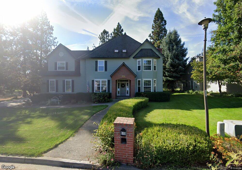
610 N Coles Loop Post Falls, ID 83854
The Highlands NeighborhoodEstimated Value: $892,000 - $1,072,000
4
Beds
4
Baths
3,885
Sq Ft
$250/Sq Ft
Est. Value
About This Home
This home is located at 610 N Coles Loop, Post Falls, ID 83854 and is currently estimated at $971,988, approximately $250 per square foot. 610 N Coles Loop is a home located in Kootenai County with nearby schools including Ponderosa Elementary School, Post Falls Middle School, and Post Falls High School.
Ownership History
Date
Name
Owned For
Owner Type
Purchase Details
Closed on
Nov 8, 2016
Sold by
Howard Donald S and Howard Barbara L
Bought by
Opdendries Brent and Opdendries Jennifer
Current Estimated Value
Home Financials for this Owner
Home Financials are based on the most recent Mortgage that was taken out on this home.
Original Mortgage
$316,000
Outstanding Balance
$253,011
Interest Rate
3.42%
Mortgage Type
VA
Estimated Equity
$718,977
Purchase Details
Closed on
Feb 3, 2015
Sold by
Wells Fargo Bank Na
Bought by
Lenz John and Howard Donald S
Purchase Details
Closed on
Jan 30, 2015
Sold by
Howard Barbara and Howard Donald S
Bought by
Howard Donald S
Purchase Details
Closed on
Jul 9, 2014
Sold by
Kelly Matthew and Kelly Nicole
Bought by
Wells Fargo Bank Na
Create a Home Valuation Report for This Property
The Home Valuation Report is an in-depth analysis detailing your home's value as well as a comparison with similar homes in the area
Home Values in the Area
Average Home Value in this Area
Purchase History
| Date | Buyer | Sale Price | Title Company |
|---|---|---|---|
| Opdendries Brent | -- | Pioneer Title Kootenai Count | |
| Opdendries Brent | -- | Pioneer Title Kootenai Count | |
| Lenz John | -- | Alliance Title | |
| Howard Donald S | -- | Alliance Title | |
| Wells Fargo Bank Na | $337,096 | Nextitle |
Source: Public Records
Mortgage History
| Date | Status | Borrower | Loan Amount |
|---|---|---|---|
| Open | Opdendries Brent | $316,000 |
Source: Public Records
Tax History
| Year | Tax Paid | Tax Assessment Tax Assessment Total Assessment is a certain percentage of the fair market value that is determined by local assessors to be the total taxable value of land and additions on the property. | Land | Improvement |
|---|---|---|---|---|
| 2025 | $5,211 | $883,950 | $215,000 | $668,950 |
| 2024 | $5,153 | $835,690 | $170,000 | $665,690 |
| 2023 | $5,153 | $925,837 | $360,000 | $565,837 |
| 2022 | $5,850 | $967,749 | $342,000 | $625,749 |
| 2021 | $6,077 | $612,977 | $180,000 | $432,977 |
| 2020 | $5,695 | $508,380 | $100,000 | $408,380 |
| 2019 | $5,923 | $477,660 | $95,000 | $382,660 |
| 2018 | $5,964 | $437,280 | $90,000 | $347,280 |
| 2017 | $6,076 | $408,740 | $80,000 | $328,740 |
| 2016 | $5,882 | $374,760 | $75,000 | $299,760 |
| 2015 | $6,058 | $380,260 | $70,000 | $310,260 |
| 2013 | $6,149 | $357,510 | $60,000 | $297,510 |
Source: Public Records
Map
Nearby Homes
- 5030 E Frazier Dr
- 706 N Dundee Dr
- 5079 E Portside Ct
- 5377 E Steamboat Bend
- 5439 E Steamboat Bend
- 1490 N Glasgow Dr
- 102 S Riverwood Ct
- 4570 E Savea Ln
- 768 N Neufeld Ln
- 5177 E Shore Cove
- 4497 E Savea Ln
- 4301 E Maplewood Ave Unit 30
- 4502 E Savea Ln
- 4519 E Savea Ln
- 4422 E Savea Ln
- 4577 E Davin Dr
- 4451 E Davin Dr
- 4470 E 16th Ave Unit 29
- 4470 E 16th Ave Unit 20
- 398 N Seeley St
- 608 N Coles Loop
- 683 N Coles
- 687 N Coles
- 681 N Coles
- 685 N Coles
- 0 N Coles
- 608 Coles Loop
- 607 N Coles Loop
- 605 N Coles Loop
- 606 N Coles Loop
- 609 N Coles Loop
- 603 N Coles Loop
- 611 N Coles Loop
- 602 N Coles Loop
- 614 N Coles Loop
- 604 N Coles Loop
- 601 N Coles Loop
- 613 N Coles Loop
- 740 N Dundee Dr
- 616 N Coles Loop
Your Personal Tour Guide
Ask me questions while you tour the home.