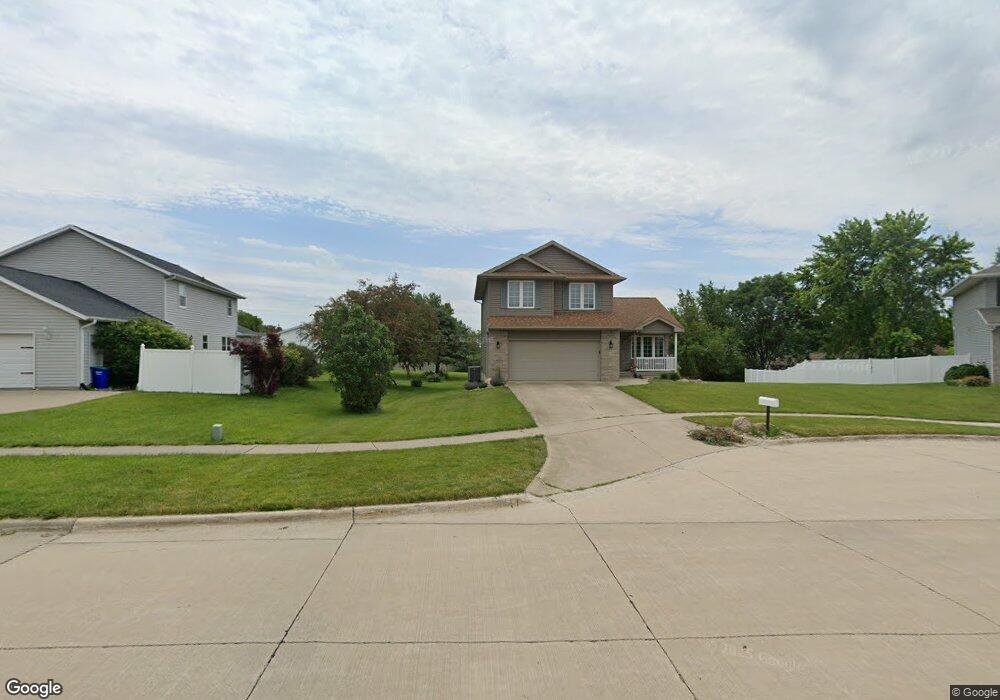
610 Tantara Ct North Liberty, IA 52317
Estimated Value: $355,341 - $390,000
3
Beds
3
Baths
1,687
Sq Ft
$220/Sq Ft
Est. Value
About This Home
This home is located at 610 Tantara Ct, North Liberty, IA 52317 and is currently estimated at $370,585, approximately $219 per square foot. 610 Tantara Ct is a home located in Johnson County with nearby schools including James Van Allen Elementary School, North Central Junior High School, and Liberty High School.
Ownership History
Date
Name
Owned For
Owner Type
Purchase Details
Closed on
Oct 21, 2022
Sold by
Forster Molly B and Forster Stephen D
Bought by
Forster Molly B
Current Estimated Value
Purchase Details
Closed on
Mar 27, 2006
Sold by
Jones Matthew B and Jones Shelley D
Bought by
Kurtz Stephen D and Forster Mary B
Home Financials for this Owner
Home Financials are based on the most recent Mortgage that was taken out on this home.
Original Mortgage
$130,000
Interest Rate
6.33%
Mortgage Type
New Conventional
Create a Home Valuation Report for This Property
The Home Valuation Report is an in-depth analysis detailing your home's value as well as a comparison with similar homes in the area
Home Values in the Area
Average Home Value in this Area
Purchase History
| Date | Buyer | Sale Price | Title Company |
|---|---|---|---|
| Forster Molly B | -- | -- | |
| Kurtz Stephen D | $202,000 | None Available |
Source: Public Records
Mortgage History
| Date | Status | Borrower | Loan Amount |
|---|---|---|---|
| Previous Owner | Kurtz Stephen D | $130,000 |
Source: Public Records
Tax History Compared to Growth
Tax History
| Year | Tax Paid | Tax Assessment Tax Assessment Total Assessment is a certain percentage of the fair market value that is determined by local assessors to be the total taxable value of land and additions on the property. | Land | Improvement |
|---|---|---|---|---|
| 2025 | $5,384 | $353,900 | $65,100 | $288,800 |
| 2024 | $5,264 | $323,300 | $65,100 | $258,200 |
| 2023 | $5,024 | $323,300 | $65,100 | $258,200 |
| 2022 | $4,762 | $267,800 | $36,600 | $231,200 |
| 2021 | $4,596 | $267,800 | $36,600 | $231,200 |
| 2020 | $4,596 | $246,800 | $36,600 | $210,200 |
| 2019 | $4,392 | $246,800 | $36,600 | $210,200 |
| 2018 | $4,306 | $236,300 | $36,600 | $199,700 |
| 2017 | $3,848 | $236,300 | $36,600 | $199,700 |
| 2016 | $3,742 | $211,000 | $36,600 | $174,400 |
| 2015 | $3,742 | $211,000 | $36,600 | $174,400 |
| 2014 | $3,650 | $211,000 | $36,600 | $174,400 |
Source: Public Records
Map
Nearby Homes
- 513 Sugar Creek Ln
- 120 Shannon Dr Unit 4
- 1105 Franklin Dr
- 820 Club House Rd Unit 4E
- 1315 Franklin St
- 1500 Harvest St
- 835 Prairie St
- 455 Heritage Place
- 445 Heritage Place
- 425 Heritage Place
- 415 Heritage Place Unit 417
- 805 Blue Sky Dr Unit 301
- 115 N Colton Dr
- 855 Blue Sky Dr Unit 304
- 142 Elm Ridge Dr
- 144 Elm Ridge Dr
- 420 W Zeller St
- 1040 Harrison St
- 1050 Harrison St
- 270 N Mckenzie Ln
- 965 Fairview Ln
- 620 Tantara Ct
- 945 Fairview Ln
- 960 Saint Andrews Dr
- 940 Saint Andrews Dr
- 625 Tantara Ct
- 980 Saint Andrews Dr
- 925 Fairview Ln
- 920 Saint Andrews Dr
- 605 Tantara Ct
- 615 Tantara Ct
- 1020 Saint Andrews Dr
- 960 Fairview Ln
- 940 Fairview Ln
- 900 Saint Andrews Dr
- 964 Fairview Ln
- 905 Fairview Ln
- 925 Saint Andrews Dr
- 945 Saint Andrews Dr
- 965 Saint Andrews Dr