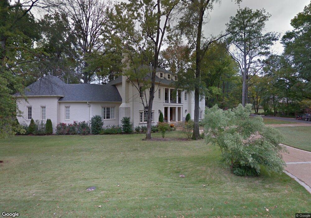
610 W Clover Dr Memphis, TN 38120
Audubon Park NeighborhoodEstimated Value: $1,023,000 - $1,639,000
5
Beds
7
Baths
5,800
Sq Ft
$240/Sq Ft
Est. Value
About This Home
This home is located at 610 W Clover Dr, Memphis, TN 38120 and is currently estimated at $1,390,072, approximately $239 per square foot. 610 W Clover Dr is a home located in Shelby County with nearby schools including White Station Elementary School, White Station High, and White Station Middle.
Ownership History
Date
Name
Owned For
Owner Type
Purchase Details
Closed on
Sep 20, 2013
Sold by
Flinn Car Edwin and Flinn Donna B J
Bought by
The Carl Edwin Flinn And Donna B Flinn R
Current Estimated Value
Purchase Details
Closed on
May 10, 2006
Sold by
The Sarah Joiner Wynn Revocable Trust
Bought by
Flinn Carl E and Flinn Donna J
Purchase Details
Closed on
Sep 30, 1999
Sold by
Wynn S J
Bought by
Wynn Sarah Joiner and Peeples Binford H
Create a Home Valuation Report for This Property
The Home Valuation Report is an in-depth analysis detailing your home's value as well as a comparison with similar homes in the area
Home Values in the Area
Average Home Value in this Area
Purchase History
| Date | Buyer | Sale Price | Title Company |
|---|---|---|---|
| The Carl Edwin Flinn And Donna B Flinn R | -- | None Available | |
| Flinn Carl E | $300,000 | Realty Title | |
| Wynn Sarah Joiner | -- | -- |
Source: Public Records
Tax History Compared to Growth
Tax History
| Year | Tax Paid | Tax Assessment Tax Assessment Total Assessment is a certain percentage of the fair market value that is determined by local assessors to be the total taxable value of land and additions on the property. | Land | Improvement |
|---|---|---|---|---|
| 2025 | $12,992 | $395,225 | $81,625 | $313,600 |
| 2024 | $12,992 | $383,250 | $67,525 | $315,725 |
| 2023 | $23,346 | $383,250 | $67,525 | $315,725 |
| 2022 | $23,346 | $383,250 | $67,525 | $315,725 |
| 2021 | $23,620 | $383,250 | $67,525 | $315,725 |
| 2020 | $25,203 | $347,825 | $67,525 | $280,300 |
| 2019 | $25,203 | $347,825 | $67,525 | $280,300 |
| 2018 | $25,203 | $347,825 | $67,525 | $280,300 |
| 2017 | $14,296 | $347,825 | $67,525 | $280,300 |
| 2016 | $13,312 | $304,625 | $0 | $0 |
| 2014 | $13,312 | $304,625 | $0 | $0 |
Source: Public Records
Map
Nearby Homes
- 591 Lexington Club Ct Unit 201
- 704 W Clover Dr
- 5305 Brantford Ave
- 501 W Racquet Club Place
- 478 W Racquet Club Place
- 5329 Laurie Ln
- 476 W Racquet Club Place
- 5484 Spainwood Ave
- 5491 Crescent Ln
- 696 Spainwood Cove
- 5481 Valleybrook Cove
- 5483 Brantford Ave
- 5393 Alladin Ave Unit 5
- 5478 Brantford Ave
- 345 S White Station Rd
- 5170 Meadowcrest Cir
- 380 Greenway Place
- 845 Reddoch St
- 5280 Cole Rd
- 839 Reddoch St
- 5298 Revere Rd
- 5279 Lexington Rd
- 5305 Lexington Rd
- 595 W Clover Dr
- 615 W Clover Dr
- 630 W Clover Dr
- 5299 Revere Rd
- 5240 Kirkside Cove
- 5250 Glynbourne Place
- 5267 Lexington Rd
- 5241 Kirkside Cove
- 5322 Revere Rd
- 637 W Clover Dr
- 5242 Glynbourne Place
- 5325 Lexington Rd
- 630 Azalea Terrace Cir
- 5280 Lexington Rd
- 634 Azalea Terrace Cir
- 5230 Kirkside Cove
- 5237 Glynbourne Place