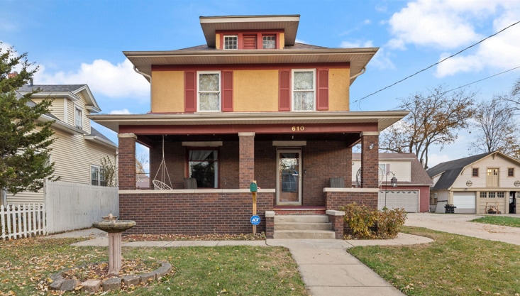


610 Watson St Aurora, IL 60505
Southeast Aurora NeighborhoodEstimated payment $2,275/month
Highlights
- Wood Flooring
- Laundry Room
- Dining Room
- Living Room
- Entrance Foyer
- Family Room
About This Home
A truly rare opportunity awaits! This distinguished oversized lot with a 4-bedroom, 2-bath single-family home offers an exceptional blend of space, modern upgrades, and timeless appeal. Set on an expansive property, it features a beautiful brick patio and massive 3-car garage complete with a large loft-perfect for gatherings, entertaining, or creating the ultimate hobby room or private retreat. Inside, you're welcomed by a graceful foyer and a stunning staircase. The home balances comfort and style with an updated kitchen and renovated bathroom, bringing a fresh, modern feel throughout. An unfinished basement and large unfinished attic provide abundant storage as well as incredible potential for future expansion-ideal for a custom suite, office, or additional living space. Recent upgrades, including a new roof in 2024, offer peace of mind and long-term value. The location enhances its lifestyle appeal, being moments from Phillips Park Zoo, Mastodon Lake, and the vast Phillips Park-yet still just minutes from I-88, shopping, and everyday conveniences. Enjoy walkable streets and nearby schools while relishing the sense of space and privacy this property provides. Offering extensive space, thoughtful updates, and exceptional surroundings, this unique home stands out as a true rare find.
Home Details
Home Type
- Single Family
Est. Annual Taxes
- $4,701
Year Built
- Built in 1917
Lot Details
- Lot Dimensions are 88 x 132
Parking
- 4 Car Garage
- Driveway
Home Design
- Brick Exterior Construction
- Asphalt Roof
Interior Spaces
- 1,605 Sq Ft Home
- 2-Story Property
- Entrance Foyer
- Family Room
- Living Room
- Dining Room
- Basement Fills Entire Space Under The House
- Laundry Room
Flooring
- Wood
- Carpet
Bedrooms and Bathrooms
- 4 Bedrooms
- 4 Potential Bedrooms
- 2 Full Bathrooms
Utilities
- Window Unit Cooling System
- Radiant Heating System
Listing and Financial Details
- Senior Tax Exemptions
- Homeowner Tax Exemptions
Map
Home Values in the Area
Average Home Value in this Area
Tax History
| Year | Tax Paid | Tax Assessment Tax Assessment Total Assessment is a certain percentage of the fair market value that is determined by local assessors to be the total taxable value of land and additions on the property. | Land | Improvement |
|---|---|---|---|---|
| 2024 | $4,701 | $76,576 | $12,270 | $64,306 |
| 2023 | $4,515 | $68,420 | $10,963 | $57,457 |
| 2022 | $4,206 | $61,357 | $10,003 | $51,354 |
| 2021 | $4,127 | $57,124 | $9,313 | $47,811 |
| 2020 | $3,914 | $53,059 | $8,650 | $44,409 |
| 2019 | $3,803 | $49,160 | $8,014 | $41,146 |
| 2018 | $3,791 | $47,631 | $7,413 | $40,218 |
| 2017 | $3,633 | $43,051 | $6,830 | $36,221 |
| 2016 | $3,416 | $38,466 | $5,855 | $32,611 |
| 2015 | -- | $33,369 | $5,035 | $28,334 |
| 2014 | -- | $30,830 | $4,627 | $26,203 |
| 2013 | -- | $31,326 | $4,654 | $26,672 |
Property History
| Date | Event | Price | List to Sale | Price per Sq Ft |
|---|---|---|---|---|
| 11/20/2025 11/20/25 | For Sale | $359,000 | -- | $224 / Sq Ft |
Purchase History
| Date | Type | Sale Price | Title Company |
|---|---|---|---|
| Warranty Deed | $116,000 | First American Title Ins Co | |
| Warranty Deed | $99,000 | Law Title Insurance Co Inc |
Mortgage History
| Date | Status | Loan Amount | Loan Type |
|---|---|---|---|
| Open | $92,800 | No Value Available | |
| Previous Owner | $94,000 | No Value Available |
Source: Midwest Real Estate Data (MRED)
MLS Number: 12521144
APN: 15-27-406-004
Disclaimer: Certain information contained herein is derived from information provided by parties other than Homes.com. All information provided is deemed reliable, but is not guaranteed to be accurate and should be independently verified.
![]() Based on information submitted to the MLS GRID. All data is obtained from various sources and may not have been verified by broker or MLS GRID. Supplied Open House Information is subject to change without notice. All information should be independently reviewed and verified for accuracy. Properties may or may not be listed by the office/agent presenting the information. Some IDX listings have been excluded from this website.
Based on information submitted to the MLS GRID. All data is obtained from various sources and may not have been verified by broker or MLS GRID. Supplied Open House Information is subject to change without notice. All information should be independently reviewed and verified for accuracy. Properties may or may not be listed by the office/agent presenting the information. Some IDX listings have been excluded from this website.
The Digital Millennium Copyright Act of 1998, 17 U.S.C. § 512 (the “DMCA”) provides recourse for copyright owners who believe that material appearing on the Internet infringes their rights under U.S. copyright law. If you believe in good faith that any content or material made available in connection with our website or services infringes your copyright, you (or your agent) may send us a notice requesting that the content or material be removed, or access to it blocked.
Notices must be sent in writing by email to DMCAnotice@MLSGrid.com.
The DMCA requires that your notice of alleged copyright infringement include the following information:
(1) description of the copyrighted work that is the subject of claimed infringement;
(2) description of the alleged infringing content and information sufficient to permit us to locate the content;
(3) contact information for you, including your address, telephone number and email address;
(4) a statement by you that you have a good faith belief that the content in the manner complained of is not authorized by the copyright owner, or its agent, or by the operation of any law;
(5) a statement by you, signed under penalty of perjury, that the information in the notification is accurate and that you have the authority to enforce the copyrights that are claimed to be infringed; and
(6) a physical or electronic signature of the copyright owner or a person authorized to act on the copyright owner’s behalf. Failure to include all of the above information may result in the delay of the processing of your complaint.
- 733 Schomer Ave
- 609 North Ave
- 1037 Howell Place
- 79 S 4th St Unit 2
- 324 Rosewood Ave
- 328 Rosewood Ave
- 220 E Downer Place
- 76 N 4th St Unit 76
- 86 N 4th St Unit 1
- 7 S Stolp Ave
- 140 S River St Unit 402
- 192 N Smith St Unit 2
- 788 Symphony Dr Unit 8046
- 839 Bishop Ave Unit 1
- 111 W Park Ave
- 1053 Symphony Dr Unit 2164
- 557 Hardin Ave
- 120 Vermont Ave
- 1500 Briarcliff Rd
- 208-212 Blackhawk St Unit 210
