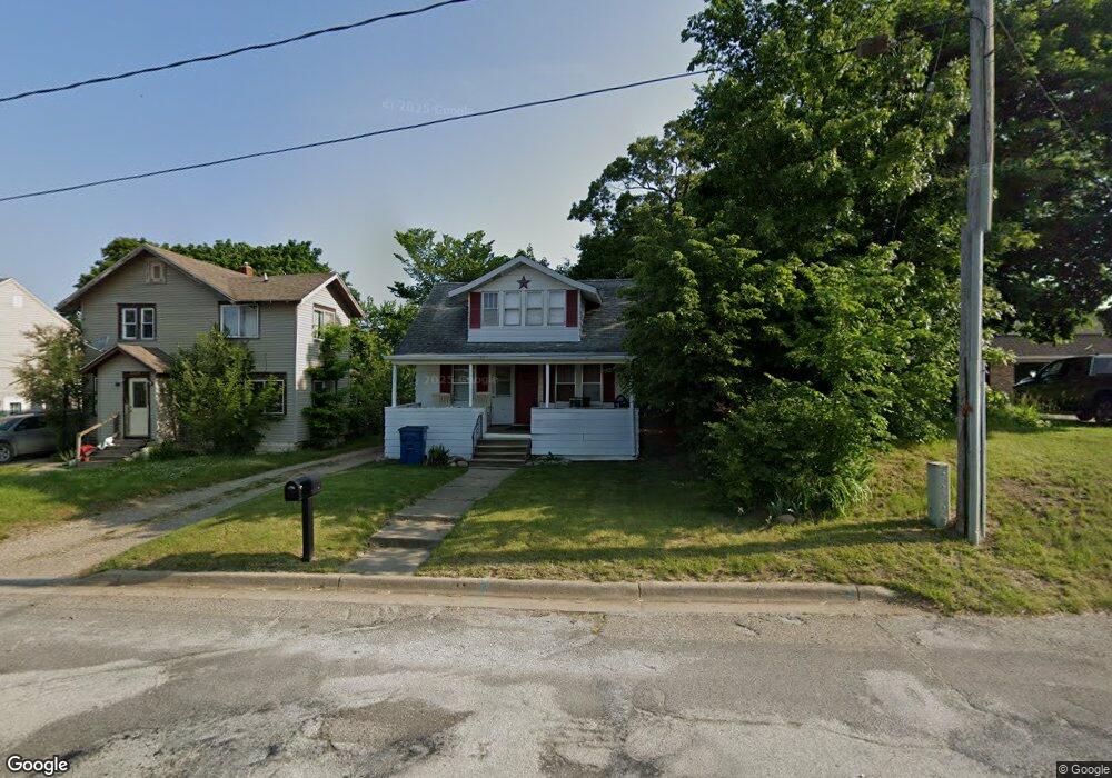
611 Cliff St Battle Creek, MI 49014
Estimated Value: $115,828 - $138,000
4
Beds
2
Baths
1,296
Sq Ft
$97/Sq Ft
Est. Value
About This Home
This home is located at 611 Cliff St, Battle Creek, MI 49014 and is currently estimated at $125,957, approximately $97 per square foot. 611 Cliff St is a home located in Calhoun County with nearby schools including Harper Creek Middle School, Harper Creek High School, and St. Philip Catholic Central High School.
Ownership History
Date
Name
Owned For
Owner Type
Purchase Details
Closed on
Nov 12, 2010
Sold by
Gunning Tim and Gunning Julie A
Bought by
Kistler Properties Llc
Current Estimated Value
Purchase Details
Closed on
May 20, 2008
Sold by
Wells Fargo Bank Na
Bought by
Gunning Tim
Purchase Details
Closed on
Jun 16, 2006
Sold by
Perry Judith H and Wells Fargo Home Mortgage Inc
Bought by
Wells Fargo Bank Na
Purchase Details
Closed on
May 8, 2003
Sold by
Adams Cathryn I and Adams Trust
Bought by
Perry Judith H
Purchase Details
Closed on
Oct 1, 2002
Sold by
Adams Cathryn
Bought by
Adams Cathryn I and Adams Trust
Create a Home Valuation Report for This Property
The Home Valuation Report is an in-depth analysis detailing your home's value as well as a comparison with similar homes in the area
Home Values in the Area
Average Home Value in this Area
Purchase History
| Date | Buyer | Sale Price | Title Company |
|---|---|---|---|
| Kistler Properties Llc | -- | None Available | |
| Gunning Tim | $9,600 | Rels Title | |
| Wells Fargo Bank Na | $54,435 | None Available | |
| Perry Judith H | $58,500 | -- | |
| Adams Cathryn I | -- | -- |
Source: Public Records
Tax History Compared to Growth
Tax History
| Year | Tax Paid | Tax Assessment Tax Assessment Total Assessment is a certain percentage of the fair market value that is determined by local assessors to be the total taxable value of land and additions on the property. | Land | Improvement |
|---|---|---|---|---|
| 2025 | $1,315 | $55,400 | $0 | $0 |
| 2024 | $936 | $50,090 | $0 | $0 |
| 2023 | $1,182 | $46,380 | $0 | $0 |
| 2022 | $849 | $45,550 | $0 | $0 |
| 2021 | $1,134 | $23,100 | $0 | $0 |
| 2020 | $1,144 | $22,500 | $0 | $0 |
| 2019 | $1,594 | $22,550 | $0 | $0 |
| 2018 | $1,008 | $20,600 | $1,850 | $18,750 |
| 2017 | $1,008 | $19,750 | $0 | $0 |
| 2016 | $1,008 | $19,150 | $0 | $0 |
| 2015 | $806 | $18,000 | $0 | $0 |
| 2014 | $806 | $18,900 | $0 | $0 |
Source: Public Records
Map
Nearby Homes
- 802 Michigan Ave E
- 23 Bradford St
- 79 Clark St
- 153 Martin St
- 138 Rook St
- 0 Rook St Unit 25019652
- 117 Inn Rd
- 116 Inn Rd
- 140 Princeton St S
- 232 Cliff St
- 118 Nelson St
- 0 E River Rd
- 174 Lathrop Ave
- 155 Post Ave
- 507 Michigan Ave E
- 501 Michigan Ave E
- 250 Silver St
- 57 Euclid St
- 180 Grenville St
- 100 Illinois St