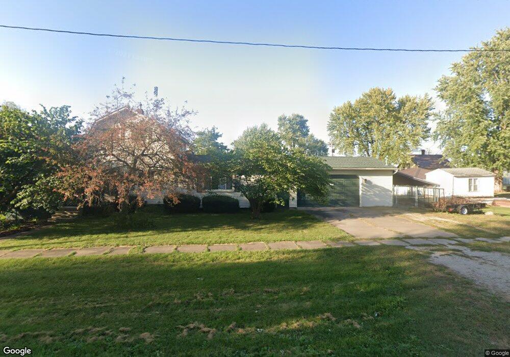
611 Nichols Ave Nichols, IA 52766
Estimated Value: $65,000 - $138,868
2
Beds
1
Bath
1,006
Sq Ft
$114/Sq Ft
Est. Value
About This Home
This home is located at 611 Nichols Ave, Nichols, IA 52766 and is currently estimated at $114,717, approximately $114 per square foot. 611 Nichols Ave is a home located in Muscatine County with nearby schools including Early Childhood Center, West Liberty Middle School, and West Liberty High School.
Ownership History
Date
Name
Owned For
Owner Type
Purchase Details
Closed on
Jun 23, 2025
Sold by
Wilson Marvin F and Wilson Sonya Y
Bought by
Moore Alexzander
Current Estimated Value
Home Financials for this Owner
Home Financials are based on the most recent Mortgage that was taken out on this home.
Original Mortgage
$62,448
Outstanding Balance
$62,288
Interest Rate
6.81%
Mortgage Type
FHA
Estimated Equity
$52,429
Create a Home Valuation Report for This Property
The Home Valuation Report is an in-depth analysis detailing your home's value as well as a comparison with similar homes in the area
Home Values in the Area
Average Home Value in this Area
Purchase History
| Date | Buyer | Sale Price | Title Company |
|---|---|---|---|
| Moore Alexzander | $64,000 | None Listed On Document |
Source: Public Records
Mortgage History
| Date | Status | Borrower | Loan Amount |
|---|---|---|---|
| Open | Moore Alexzander | $62,448 |
Source: Public Records
Tax History Compared to Growth
Tax History
| Year | Tax Paid | Tax Assessment Tax Assessment Total Assessment is a certain percentage of the fair market value that is determined by local assessors to be the total taxable value of land and additions on the property. | Land | Improvement |
|---|---|---|---|---|
| 2025 | $1,333 | $114,410 | $12,650 | $101,760 |
| 2024 | $1,333 | $113,690 | $12,650 | $101,040 |
| 2023 | $11 | $104,113 | $12,614 | $91,499 |
| 2022 | $1,250 | $101,390 | $11,900 | $89,490 |
| 2021 | $1,252 | $90,480 | $11,900 | $78,580 |
| 2020 | $1,281 | $85,710 | $11,900 | $73,810 |
| 2019 | $1,353 | $83,310 | $0 | $0 |
| 2018 | $1,326 | $83,310 | $0 | $0 |
| 2017 | $1,314 | $85,610 | $0 | $0 |
| 2016 | $1,394 | $85,610 | $0 | $0 |
| 2015 | $1,394 | $77,720 | $0 | $0 |
| 2014 | $1,248 | $77,720 | $0 | $0 |
Source: Public Records
Map
Nearby Homes
- 306 Broadway St
- 612 Nichols Ave
- 619 Nichols Ave
- 519 Nichols Ave
- 305 Pleasant St
- 303 Broadway St
- 618 Nichols Ave
- 210 Broadway St
- 305 Broadway St
- 310 Broadway St
- 518 Nichols Ave
- 307 Broadway St
- 309 Pleasant St
- 312 Broadway St
- 209 Broadway St
- 505 Nichols Ave
- 311 Broadway St
- 316 Main St
- 212 Main St
- 202 Broadway St