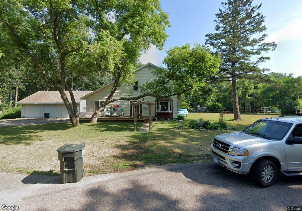
611 Pine St Crosby, MN 56441
Estimated Value: $273,000 - $316,000
5
Beds
1
Bath
1,920
Sq Ft
$152/Sq Ft
Est. Value
About This Home
This home is located at 611 Pine St, Crosby, MN 56441 and is currently estimated at $291,746, approximately $151 per square foot. 611 Pine St is a home located in Crow Wing County with nearby schools including Cuyuna Range Elementary School and Crosby-Ironton Secondary School.
Ownership History
Date
Name
Owned For
Owner Type
Purchase Details
Closed on
Mar 9, 2017
Bought by
Mayer Colin and Mayer Anna
Current Estimated Value
Home Financials for this Owner
Home Financials are based on the most recent Mortgage that was taken out on this home.
Original Mortgage
$51,600
Outstanding Balance
$42,813
Interest Rate
4.19%
Estimated Equity
$248,933
Purchase Details
Closed on
Apr 1, 2006
Bought by
Gripentrog Brant
Create a Home Valuation Report for This Property
The Home Valuation Report is an in-depth analysis detailing your home's value as well as a comparison with similar homes in the area
Purchase History
| Date | Buyer | Sale Price | Title Company |
|---|---|---|---|
| Mayer Colin | $64,500 | -- | |
| Gripentrog Brant | $129,900 | -- |
Source: Public Records
Mortgage History
| Date | Status | Borrower | Loan Amount |
|---|---|---|---|
| Open | Mayer Colin | $51,600 |
Source: Public Records
Tax History
| Year | Tax Paid | Tax Assessment Tax Assessment Total Assessment is a certain percentage of the fair market value that is determined by local assessors to be the total taxable value of land and additions on the property. | Land | Improvement |
|---|---|---|---|---|
| 2025 | $1,982 | $264,600 | $63,000 | $201,600 |
| 2024 | $1,982 | $261,400 | $60,800 | $200,600 |
| 2023 | $2,044 | $255,800 | $56,900 | $198,900 |
| 2022 | $1,686 | $231,100 | $39,500 | $191,600 |
| 2021 | $1,500 | $161,800 | $33,200 | $128,600 |
| 2020 | $1,352 | $146,300 | $31,500 | $114,800 |
| 2019 | $1,428 | $121,300 | $26,400 | $94,900 |
| 2018 | $998 | $130,200 | $21,300 | $108,900 |
| 2017 | $926 | $79,417 | $23,306 | $56,111 |
| 2016 | $3,284 | $74,000 | $19,200 | $54,800 |
| 2015 | $3,280 | $71,600 | $19,000 | $52,600 |
| 2014 | $1,633 | $70,900 | $16,700 | $54,200 |
Source: Public Records
Map
Nearby Homes
- 503 Franklin Ave
- 426 Erie Ave
- 424 Erie Ave
- TBD Michigan Ave
- 413 4th St SW
- Lot 4 Woods Edge Ct
- Lot 7 Woods Edge Ct
- 20957 Woods Edge Ct
- 20972 Woods Edge Ct
- 415 1st St SW
- 22 1st St SW
- TBD Lot 6 Irene Ave
- 21414 Beach Rd
- 210 3rd St NW
- 16 Deblock Ln
- 12 Deblock Dr
- 10 Deblock Dr
- Tract C County Road 12
- Parcel E Rogue Way
- 225 Viola Ave
- 605 Pine St
- 620 Franklin Ave
- XXX Franklin Ave
- 627 Franklin Ave
- 603 Franklin Ave
- 603 Franklin Ave
- 611 Birch St
- 611 Birch St
- XXX Lots 10 & 11 Franklin Ave
- 701 Birch St
- 618 Erie Ave
- 616 Erie Ave
- 703 Birch St
- 20767 Hematite St
- 529 Franklin Ave
- 705 Birch St
- 707 Birch St
- 630 Erie Ave
- 602 Erie Ave
- 710 Oak St
Your Personal Tour Guide
Ask me questions while you tour the home.