Estimated Value: $215,000 - $279,000
--
Bed
--
Bath
1,832
Sq Ft
$142/Sq Ft
Est. Value
About This Home
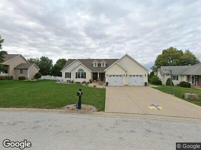
This home is located at 611 W Monroe St, Maroa, IL 61756 and is currently estimated at $260,701, approximately $142 per square foot. 611 W Monroe St is a home located in Macon County with nearby schools including Maroa-Forsyth Grade School, Maroa-Forsyth Middle School, and Maroa-Forsyth Senior High School.
Ownership History
Date
Name
Owned For
Owner Type
Purchase Details
Closed on
Aug 17, 2005
Sold by
Young Richard E
Bought by
Jostes Joshua M and Jostes Heidi M
Current Estimated Value
Home Financials for this Owner
Home Financials are based on the most recent Mortgage that was taken out on this home.
Original Mortgage
$155,000
Interest Rate
5.82%
Mortgage Type
New Conventional
Purchase Details
Closed on
Mar 26, 2005
Sold by
Hamilton Development Co
Bought by
Young Richard E
Home Financials for this Owner
Home Financials are based on the most recent Mortgage that was taken out on this home.
Original Mortgage
$180,000
Interest Rate
6.5%
Mortgage Type
Construction
Create a Home Valuation Report for This Property
The Home Valuation Report is an in-depth analysis detailing your home's value as well as a comparison with similar homes in the area
Home Values in the Area
Average Home Value in this Area
Purchase History
| Date | Buyer | Sale Price | Title Company |
|---|---|---|---|
| Jostes Joshua M | $216,500 | None Available | |
| Young Richard E | $19,000 | None Available |
Source: Public Records
Mortgage History
| Date | Status | Borrower | Loan Amount |
|---|---|---|---|
| Open | Jostes Joshua M | $30,000 | |
| Open | Jostes Joshua M | $182,005 | |
| Closed | Jostes Joshua M | $14,000 | |
| Closed | Jostes Joshlia M | $161,769 | |
| Closed | Jostes Joshua M | $30,000 | |
| Closed | Jostes Joshua M | $165,559 | |
| Closed | Jostes Joshua M | $155,000 | |
| Previous Owner | Young Richard E | $180,000 |
Source: Public Records
Tax History Compared to Growth
Tax History
| Year | Tax Paid | Tax Assessment Tax Assessment Total Assessment is a certain percentage of the fair market value that is determined by local assessors to be the total taxable value of land and additions on the property. | Land | Improvement |
|---|---|---|---|---|
| 2023 | $7,118 | $82,757 | $11,037 | $71,720 |
| 2022 | $6,713 | $78,064 | $10,411 | $67,653 |
| 2021 | $6,474 | $74,150 | $9,889 | $64,261 |
| 2020 | $5,902 | $69,875 | $9,319 | $60,556 |
| 2019 | $5,902 | $69,875 | $9,319 | $60,556 |
| 2018 | $5,630 | $68,217 | $9,098 | $59,119 |
| 2017 | $5,891 | $68,504 | $9,136 | $59,368 |
| 2016 | $5,878 | $68,422 | $9,125 | $59,297 |
| 2015 | $4,931 | $66,429 | $8,859 | $57,570 |
| 2014 | $4,768 | $65,771 | $8,771 | $57,000 |
| 2013 | $4,815 | $65,771 | $8,771 | $57,000 |
Source: Public Records
Map
Nearby Homes
- 212 W Washington St
- 218 S Oak St
- 410 E Kennedy St
- 1076 U S 51
- 8527 Sawyer Rd
- 1650 Schellabarger Rd
- 0 Betty Ln Unit 10514801
- 6080 Stagecoach Rd
- 6150 Stagecoach Rd
- 72 Edgelea Dr
- 4877 Tunbridge Hill Rd
- 164 Shadow Ridge Blvd
- 157 Shadow Ridge Blvd
- 1029 Jemima St
- 1026 State Route 10 E
- 701 S Cain St
- 120 Shadow Ridge Blvd
- 130 S Grant St
- 450 Phillip Cir
- 212 E Jefferson St