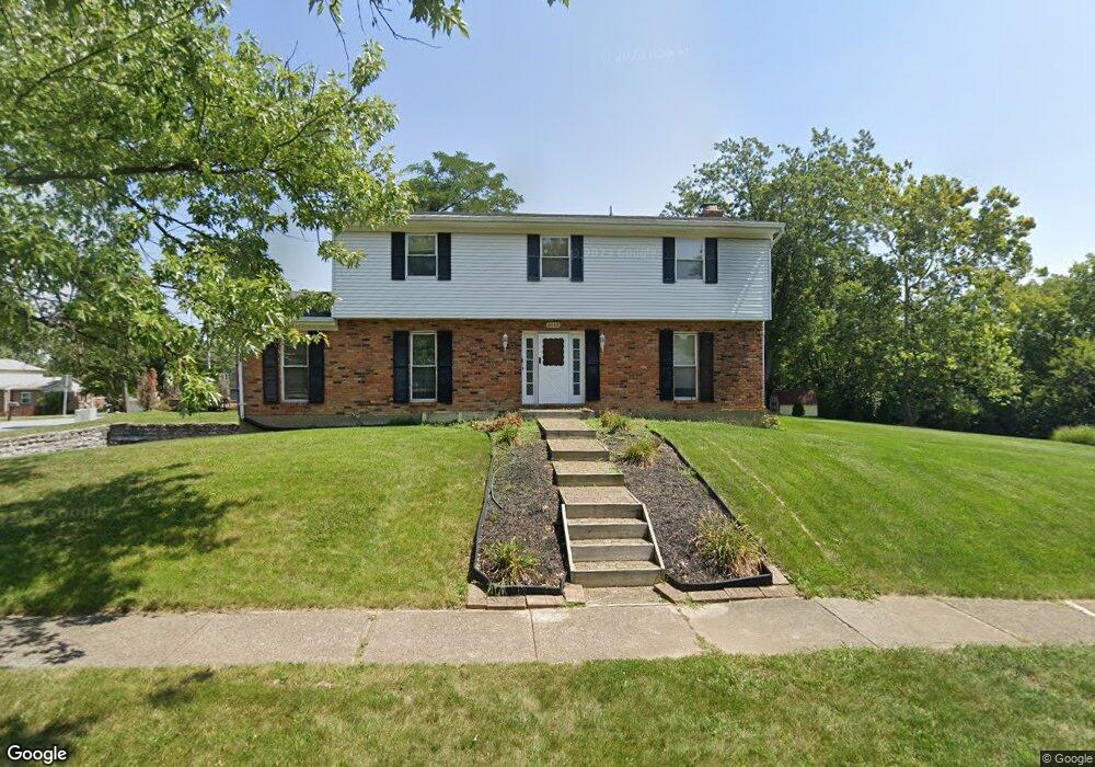
6112 Stone Hill Dr Fairfield, OH 45014
Estimated Value: $344,817 - $393,000
4
Beds
3
Baths
2,305
Sq Ft
$157/Sq Ft
Est. Value
About This Home
This home is located at 6112 Stone Hill Dr, Fairfield, OH 45014 and is currently estimated at $361,704, approximately $156 per square foot. 6112 Stone Hill Dr is a home located in Butler County with nearby schools including Compass Elementary School, Creekside Middle School, and Fairfield Senior High School.
Ownership History
Date
Name
Owned For
Owner Type
Purchase Details
Closed on
Nov 16, 1998
Sold by
Diane Craig Leroy Burton Bills and Craig Diane
Bought by
Craig Leroy Burton and Craig Diane
Current Estimated Value
Home Financials for this Owner
Home Financials are based on the most recent Mortgage that was taken out on this home.
Original Mortgage
$132,000
Outstanding Balance
$29,879
Interest Rate
7.01%
Mortgage Type
Purchase Money Mortgage
Estimated Equity
$331,825
Purchase Details
Closed on
Aug 30, 1995
Sold by
Lombardo Edward C
Bought by
Craig Leroy B and Bills Diane
Home Financials for this Owner
Home Financials are based on the most recent Mortgage that was taken out on this home.
Original Mortgage
$123,400
Interest Rate
7.55%
Mortgage Type
New Conventional
Create a Home Valuation Report for This Property
The Home Valuation Report is an in-depth analysis detailing your home's value as well as a comparison with similar homes in the area
Home Values in the Area
Average Home Value in this Area
Purchase History
| Date | Buyer | Sale Price | Title Company |
|---|---|---|---|
| Craig Leroy Burton | -- | -- | |
| Craig Leroy B | $129,900 | -- |
Source: Public Records
Mortgage History
| Date | Status | Borrower | Loan Amount |
|---|---|---|---|
| Open | Craig Leroy Burton | $132,000 | |
| Closed | Craig Leroy B | $123,400 |
Source: Public Records
Tax History Compared to Growth
Tax History
| Year | Tax Paid | Tax Assessment Tax Assessment Total Assessment is a certain percentage of the fair market value that is determined by local assessors to be the total taxable value of land and additions on the property. | Land | Improvement |
|---|---|---|---|---|
| 2024 | $3,457 | $91,850 | $14,000 | $77,850 |
| 2023 | $3,440 | $91,230 | $14,000 | $77,230 |
| 2022 | $3,194 | $65,330 | $14,000 | $51,330 |
| 2021 | $2,778 | $64,320 | $14,000 | $50,320 |
| 2020 | $2,889 | $64,320 | $14,000 | $50,320 |
| 2019 | $4,772 | $55,270 | $14,010 | $41,260 |
| 2018 | $2,822 | $55,270 | $14,010 | $41,260 |
| 2017 | $2,837 | $55,270 | $14,010 | $41,260 |
| 2016 | $2,739 | $50,790 | $14,010 | $36,780 |
| 2015 | $2,611 | $50,790 | $14,010 | $36,780 |
| 2014 | $2,541 | $50,790 | $14,010 | $36,780 |
| 2013 | $2,541 | $51,810 | $14,010 | $37,800 |
Source: Public Records
Map
Nearby Homes
- 40 Applewood Dr Unit 40
- 48 Applewood Dr Unit 48
- 3323 Devonian Dr
- 74 Applewood Dr
- 20 N Applewood Ct Unit 151
- 4 Old Duxbury Ct
- 19 Caribou Ct
- 58 Twin Lakes Dr
- 5890 Kay Dr
- 62 Twin Lakes Dr
- 12189 Kenn Rd
- 992 Olde Station Ct
- 867 Yorkhaven Rd
- 7 Darby Ct Unit 67
- 17 Springbok Dr
- 3745 Mack Rd
- 4351 Whitmore Ln
- 4 Shoal Meadows Ct
- 62 Ironwood Ct
- 15 Overlook Ct
- 3395 Mack Rd
- 6124 Stone Hill Dr
- 3405 Mack Rd
- 6111 Stone Hill Dr
- 6136 Stone Hill Dr
- 6101 Delcrest Dr
- 3364 Mack Rd
- 3415 Mack Rd
- 6144 Stone Hill Dr
- 3321 Mack Rd
- 6107 Delcrest Dr
- 3316 Cherry Hill Dr
- 3320 Mack Rd
- 6113 Delcrest Dr
- 6152 Stone Hill Dr
- 3328 Cherry Hill Dr
- 3425 Mack Rd
- 3311 Mack Rd
- 3315 Cherry Hill Dr
- 6106 Delcrest Dr