Estimated Value: $274,379 - $447,000
3
Beds
2
Baths
2,138
Sq Ft
$163/Sq Ft
Est. Value
About This Home
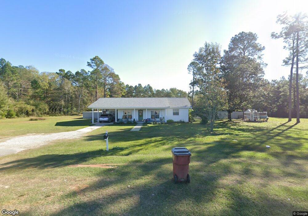
This home is located at 6115 Highway 189 N, Baker, FL 32531 and is currently estimated at $348,845, approximately $163 per square foot. 6115 Highway 189 N is a home located in Okaloosa County with nearby schools including Baker School.
Ownership History
Date
Name
Owned For
Owner Type
Purchase Details
Closed on
May 15, 2006
Sold by
Mainor James Bradley and Mainor Wendy K
Bought by
Mainor James Bradley and Mainor Wendy K
Current Estimated Value
Home Financials for this Owner
Home Financials are based on the most recent Mortgage that was taken out on this home.
Original Mortgage
$135,200
Interest Rate
6.41%
Mortgage Type
Fannie Mae Freddie Mac
Create a Home Valuation Report for This Property
The Home Valuation Report is an in-depth analysis detailing your home's value as well as a comparison with similar homes in the area
Home Values in the Area
Average Home Value in this Area
Purchase History
| Date | Buyer | Sale Price | Title Company |
|---|---|---|---|
| Mainor James Bradley | -- | First Natl Land Title Co Inc | |
| Mainor James Bradley | -- | First Natl Land Title Co Inc |
Source: Public Records
Mortgage History
| Date | Status | Borrower | Loan Amount |
|---|---|---|---|
| Closed | Mainor James Bradley | $135,200 |
Source: Public Records
Tax History Compared to Growth
Tax History
| Year | Tax Paid | Tax Assessment Tax Assessment Total Assessment is a certain percentage of the fair market value that is determined by local assessors to be the total taxable value of land and additions on the property. | Land | Improvement |
|---|---|---|---|---|
| 2024 | $542 | $83,742 | -- | -- |
| 2023 | $542 | $81,303 | $0 | $0 |
| 2022 | $525 | $78,935 | $0 | $0 |
| 2021 | $515 | $76,636 | $0 | $0 |
| 2020 | $498 | $74,951 | $0 | $0 |
| 2019 | $487 | $73,266 | $0 | $0 |
| 2018 | $884 | $76,013 | $0 | $0 |
| 2017 | $853 | $71,874 | $0 | $0 |
| 2016 | $828 | $70,347 | $0 | $0 |
| 2015 | $804 | $66,111 | $0 | $0 |
| 2014 | $810 | $65,968 | $0 | $0 |
Source: Public Records
Map
Nearby Homes
- 6043 Dairy Rd
- 0 Homestead Rd
- 1495 Mccauley Rd
- 5811 Monroe St
- 1354 Georgia Ave
- 1704 Cobb Rd
- TBD Will Henry Ln
- 6100 Buck Ward Rd
- 6090 Buck Ward Rd
- 0 Jackson St
- 5609 Price Plantation Rd
- 1509 Long Needle Ct
- 6064 Buck Ward Rd
- F-10 Long Branch Farm Rd
- 5994 Highway 4 W
- F-9 Long Branch Farm Rd
- F-8 Long Branch Farms Rd
- 924 Hwy C4a
- 5630 Price Plantation Rd
- F-3 Long Branch Farm Rd
- 6107 Holloway Rd
- 6119 Holloway Rd
- 1306 Highway C 4a
- 6063 Dairy Rd
- 6065 Dairy Rd
- 6135 Holloway Rd
- 6053 Dairy Rd
- 6161 Highway 189 N
- 6156 Holloway Rd
- 6160 Holloway Rd
- 6183 Highway 189 N
- 6163 Holloway Rd
- 6023 Dairy Rd
- XXX Holloway Rd
- 1276 Highway C 4a
- 6127 Wills Way
- 6107 Wills Way
- 6009 Dairy Rd
- 6187 Holloway Rd
- 6201 Holloway Rd