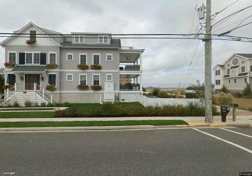
6118 Ocean Dr Avalon, NJ 08202
Estimated Value: $4,082,528 - $5,307,000
Studio
--
Bath
2,749
Sq Ft
$1,740/Sq Ft
Est. Value
About This Home
This home is located at 6118 Ocean Dr, Avalon, NJ 08202 and is currently estimated at $4,782,882, approximately $1,739 per square foot. 6118 Ocean Dr is a home located in Cape May County with nearby schools including Avalon Elementary School.
Ownership History
Date
Name
Owned For
Owner Type
Purchase Details
Closed on
Dec 4, 2012
Sold by
Bednar Robert J and Bednar Barbara
Bought by
Bednar Robert J and Bednar Deborah A
Current Estimated Value
Home Financials for this Owner
Home Financials are based on the most recent Mortgage that was taken out on this home.
Original Mortgage
$825,000
Outstanding Balance
$585,389
Interest Rate
3.44%
Mortgage Type
Purchase Money Mortgage
Estimated Equity
$4,197,493
Purchase Details
Closed on
Apr 10, 2002
Sold by
Behl James E
Bought by
Bednar Robert J and Bednar Barbara
Home Financials for this Owner
Home Financials are based on the most recent Mortgage that was taken out on this home.
Original Mortgage
$1,690,000
Interest Rate
7.18%
Create a Home Valuation Report for This Property
The Home Valuation Report is an in-depth analysis detailing your home's value as well as a comparison with similar homes in the area
Home Values in the Area
Average Home Value in this Area
Purchase History
| Date | Buyer | Sale Price | Title Company |
|---|---|---|---|
| Bednar Robert J | $1,625,000 | Shore Title Agency Inc | |
| Bednar Robert J | $1,750,000 | -- |
Source: Public Records
Mortgage History
| Date | Status | Borrower | Loan Amount |
|---|---|---|---|
| Open | Bednar Robert J | $825,000 | |
| Previous Owner | Bednar Robert J | $1,690,000 |
Source: Public Records
Tax History
| Year | Tax Paid | Tax Assessment Tax Assessment Total Assessment is a certain percentage of the fair market value that is determined by local assessors to be the total taxable value of land and additions on the property. | Land | Improvement |
|---|---|---|---|---|
| 2025 | $18,341 | $2,987,200 | $2,272,500 | $714,700 |
| 2024 | $18,341 | $2,987,200 | $2,272,500 | $714,700 |
| 2023 | $18,192 | $2,987,200 | $2,272,500 | $714,700 |
| 2022 | $16,967 | $2,987,200 | $2,272,500 | $714,700 |
| 2021 | $11,426 | $2,987,200 | $2,272,500 | $714,700 |
| 2020 | $15,713 | $2,987,200 | $2,272,500 | $714,700 |
| 2019 | $15,235 | $2,987,200 | $2,272,500 | $714,700 |
| 2018 | $14,578 | $2,987,200 | $2,272,500 | $714,700 |
| 2017 | $16,307 | $2,932,900 | $2,247,100 | $685,800 |
| 2016 | $16,131 | $2,932,900 | $2,247,100 | $685,800 |
| 2015 | $15,867 | $2,932,900 | $2,247,100 | $685,800 |
| 2014 | $15,691 | $2,932,900 | $2,247,100 | $685,800 |
Source: Public Records
Map
Nearby Homes
- 6229 Dune Dr
- 5765 Ocean Dr
- 150 64th St
- 6762 Ocean Dr Unit 6762
- 6772 Ocean Dr Unit 6772
- 177 71st St
- 7463 Ocean Dr
- 4640 Ocean Dr
- 4610 4th Ave
- 7800 Dune Dr Unit C205
- 315 79th St Unit 315
- 7888 Dune Dr Unit 218
- 280 79th St Unit 1
- 7900 Dune Dr Unit C315
- 301 80th St Unit B24
- 7929 Dune Dr Unit 212
- 256 42nd St
- 248 81st St Unit A
- 264 41st St
- 8201 3rd Ave Unit 24
Your Personal Tour Guide
Ask me questions while you tour the home.