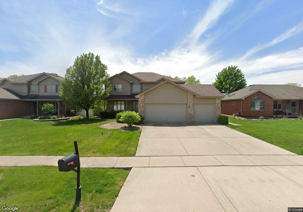
612 High Grove Dr Minooka, IL 60447
Estimated Value: $425,305 - $432,000
--
Bed
--
Bath
2,568
Sq Ft
$167/Sq Ft
Est. Value
About This Home
This home is located at 612 High Grove Dr, Minooka, IL 60447 and is currently estimated at $428,826, approximately $166 per square foot. 612 High Grove Dr is a home with nearby schools including Minooka Primary Center, Minooka Elementary School, and Minooka Junior High School.
Ownership History
Date
Name
Owned For
Owner Type
Purchase Details
Closed on
May 15, 2023
Sold by
Chicago Title Land Trust Company
Bought by
Smith Brian J
Current Estimated Value
Home Financials for this Owner
Home Financials are based on the most recent Mortgage that was taken out on this home.
Original Mortgage
$228,835
Outstanding Balance
$222,518
Interest Rate
6.43%
Mortgage Type
New Conventional
Estimated Equity
$206,308
Purchase Details
Closed on
Jul 30, 2016
Sold by
Smith Brian J
Bought by
Chicago Title Land Trusr Co
Purchase Details
Closed on
Jul 8, 2015
Sold by
Smith Jennifer A
Bought by
Smith Brian J
Create a Home Valuation Report for This Property
The Home Valuation Report is an in-depth analysis detailing your home's value as well as a comparison with similar homes in the area
Home Values in the Area
Average Home Value in this Area
Purchase History
| Date | Buyer | Sale Price | Title Company |
|---|---|---|---|
| Smith Brian J | -- | None Listed On Document | |
| Chicago Title Land Trusr Co | -- | None Available | |
| Smith Brian J | -- | None Available |
Source: Public Records
Mortgage History
| Date | Status | Borrower | Loan Amount |
|---|---|---|---|
| Open | Smith Brian J | $228,835 |
Source: Public Records
Tax History Compared to Growth
Tax History
| Year | Tax Paid | Tax Assessment Tax Assessment Total Assessment is a certain percentage of the fair market value that is determined by local assessors to be the total taxable value of land and additions on the property. | Land | Improvement |
|---|---|---|---|---|
| 2024 | $10,565 | $131,711 | $30,462 | $101,249 |
| 2023 | $9,630 | $120,054 | $27,766 | $92,288 |
| 2022 | $8,473 | $111,626 | $25,817 | $85,809 |
| 2021 | $8,119 | $105,667 | $24,439 | $81,228 |
| 2020 | $7,924 | $101,080 | $23,378 | $77,702 |
| 2019 | $7,491 | $93,592 | $21,646 | $71,946 |
| 2018 | $6,342 | $78,361 | $21,404 | $56,957 |
| 2017 | $6,158 | $74,829 | $20,439 | $54,390 |
| 2016 | $5,752 | $70,242 | $19,186 | $51,056 |
| 2015 | $4,945 | $63,850 | $17,440 | $46,410 |
| 2014 | $4,492 | $60,327 | $16,478 | $43,849 |
| 2013 | $4,616 | $61,140 | $16,700 | $44,440 |
Source: Public Records
Map
Nearby Homes
- 605 High Grove Dr
- 601 Edgewater Dr
- 703 Stillwater Ct
- 802 Joanne Dr
- 406 Mccoy Ct
- 713 Joanne Dr
- LOT 28 O Toole Dr
- 401 Feeney Dr
- 817 Casey Dr
- 504 Flanagan Dr Unit A
- 278,279,280,281 Clover Cir
- Lots 298-301 Clover Cir
- 1074-1080 Clover Dr
- 314 Golden Rod Dr
- 246 Prairie Ridge Dr
- 825 Grant Dr
- 324 Wabena Ct
- 1420 Marigold Ln
- 1404 Plantain Dr
- 1118 Burns Ln
- 614 High Grove Dr
- 608 High Grove Dr
- 616 High Grove Dr
- 611 High Grove Dr
- 609 High Grove Dr
- 607 High Grove Dr
- 806 Windsong Ct
- 606 High Grove Dr
- 618 High Grove Dr
- 804 Windsong Ct
- 604 High Grove Dr
- 702 High Grove Dr
- 707 Overlook Ct
- 603 High Grove Dr
- 807 Windsong Ct
- 705 Overlook Ct
- 602 High Grove Dr
- 708 Overlook Ct
- 704 High Grove Dr
- 802 Windsong Ct