Estimated Value: $693,000 - $783,000
5
Beds
5
Baths
2,770
Sq Ft
$270/Sq Ft
Est. Value
About This Home
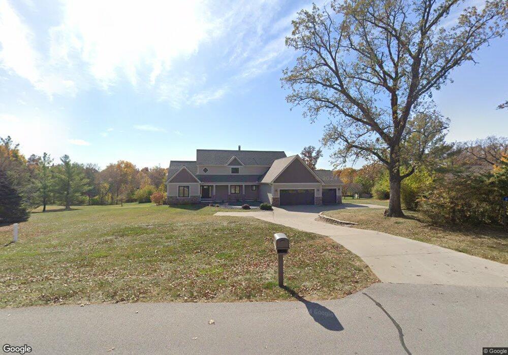
This home is located at 6121 N Fork Rd, Ames, IA 50010 and is currently estimated at $747,649, approximately $269 per square foot. 6121 N Fork Rd is a home located in Story County with nearby schools including Central Elementary School, Nevada Middle School, and Nevada High School.
Ownership History
Date
Name
Owned For
Owner Type
Purchase Details
Closed on
Aug 12, 2021
Sold by
Sondgeroth Gary W and Sondgeroth Rhonda K
Bought by
Kollos Tammy Kay and Kollos Jeffrey Gerald
Current Estimated Value
Home Financials for this Owner
Home Financials are based on the most recent Mortgage that was taken out on this home.
Original Mortgage
$425,000
Outstanding Balance
$385,286
Interest Rate
2.7%
Mortgage Type
New Conventional
Estimated Equity
$362,363
Purchase Details
Closed on
Sep 5, 2006
Sold by
Murray Peter Keith and Perry Murray Jean Letham
Bought by
Sondgeroth Gary W and Sondgeroth Rhonda K
Home Financials for this Owner
Home Financials are based on the most recent Mortgage that was taken out on this home.
Original Mortgage
$297,600
Interest Rate
6.49%
Mortgage Type
New Conventional
Create a Home Valuation Report for This Property
The Home Valuation Report is an in-depth analysis detailing your home's value as well as a comparison with similar homes in the area
Purchase History
| Date | Buyer | Sale Price | Title Company |
|---|---|---|---|
| Kollos Tammy Kay | $625,000 | None Available | |
| Sondgeroth Gary W | $372,000 | None Available |
Source: Public Records
Mortgage History
| Date | Status | Borrower | Loan Amount |
|---|---|---|---|
| Open | Kollos Tammy Kay | $425,000 | |
| Previous Owner | Sondgeroth Gary W | $297,600 |
Source: Public Records
Tax History
| Year | Tax Paid | Tax Assessment Tax Assessment Total Assessment is a certain percentage of the fair market value that is determined by local assessors to be the total taxable value of land and additions on the property. | Land | Improvement |
|---|---|---|---|---|
| 2025 | $7,704 | $725,800 | $222,800 | $503,000 |
| 2024 | $7,418 | $683,100 | $194,100 | $489,000 |
| 2023 | $8,396 | $683,100 | $194,100 | $489,000 |
| 2022 | $6,062 | $624,400 | $138,700 | $485,700 |
| 2021 | $6,248 | $460,000 | $138,700 | $321,300 |
| 2020 | $6,096 | $440,400 | $138,700 | $301,700 |
| 2019 | $6,096 | $440,400 | $138,700 | $301,700 |
| 2018 | $6,326 | $417,900 | $138,700 | $279,200 |
| 2017 | $6,326 | $417,900 | $138,700 | $279,200 |
| 2016 | $6,434 | $427,200 | $138,700 | $288,500 |
| 2015 | $6,434 | $427,200 | $138,700 | $288,500 |
| 2014 | $6,572 | $427,200 | $138,700 | $288,500 |
Source: Public Records
Map
Nearby Homes
- 7200 Bantry Ct
- 4882 Copperstone Dr
- 6235 U S 69
- 6235 US Highway 69
- 3124 Grove Ave
- 1827 Ledges Dr
- 1920 Ada Hayden Rd
- 2006 Aikman Dr
- 2007 Ketelsen Dr
- 2242 Ketelsen Dr
- 2206 Ketelsen Dr
- 1515 Stone Brooke Rd
- 2123 Ketelsen Dr
- 4131 Stone Brooke Rd
- 4033 Fletcher Blvd
- 1941 Paulson Dr
- 3917 Fletcher Ct
- 4227 Eisenhower Ct
- 3814 Brookdale Ave
- 2112 Furman Dr
- 6121 Northfork Rd
- 6121 Northfork Rd
- 6131 Northfork Rd
- 6107 N Fork Rd
- 6112 Northfork Rd
- 6112 Northfork Rd
- 6135 Northfork Rd
- 2364 Quail Ridge Rd
- 5525 N Dayton Ave
- 6130 Northfork Rd
- 5652 N Dayton Ave
- 2240 Quail Ridge Rd
- 2279 E 190th St
- 6148 Northfork Rd
- 2305 Dayton Ridge Rd
- 2395 Quail Ridge Rd
- 2243 Quail Ridge Rd
- 2200 Quail Ridge Rd
- 2372 Dayton Ridge Rd
- 6168 Northfork Rd
Your Personal Tour Guide
Ask me questions while you tour the home.