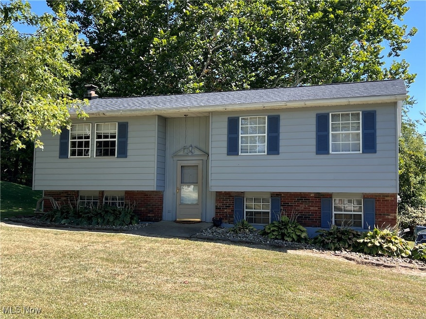
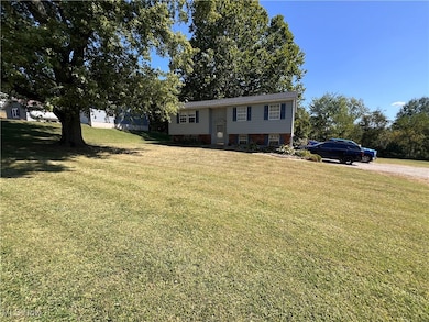


61220 Kadon Dr New Concord, OH 43762
Estimated payment $1,448/month
Highlights
- No HOA
- 2 Car Attached Garage
- Forced Air Heating and Cooling System
About This Home
This beautiful 3 bed 2 bath split level home is waiting for you! New roof in 2023, new furnace, central air and water heater in 2022, and a new rear deck just added two weeks ago! Quiet area conveniently located between New Concord and Cambridge. This home also has a pellet stove for back up heat!
Listing Agent
J. Moore Realty Group, LLC. Brokerage Email: 740-487-0081, jessy@jmoorerealtygroup.com License #2022007210 Listed on: 09/12/2025
Home Details
Home Type
- Single Family
Est. Annual Taxes
- $2,272
Year Built
- Built in 1978
Parking
- 2 Car Attached Garage
- Driveway
Home Design
- Split Level Home
- Block Foundation
- Aluminum Siding
Bedrooms and Bathrooms
- 3 Main Level Bedrooms
- 2 Full Bathrooms
Additional Features
- 2-Story Property
- 0.38 Acre Lot
- Forced Air Heating and Cooling System
- Basement
Community Details
- No Home Owners Association
- Colonial Heights Sub Subdivision
Listing and Financial Details
- Assessor Parcel Number 41-0000542.000
Map
Home Values in the Area
Average Home Value in this Area
Tax History
| Year | Tax Paid | Tax Assessment Tax Assessment Total Assessment is a certain percentage of the fair market value that is determined by local assessors to be the total taxable value of land and additions on the property. | Land | Improvement |
|---|---|---|---|---|
| 2024 | $2,272 | $58,044 | $14,847 | $43,197 |
| 2023 | $2,272 | $44,307 | $11,333 | $32,974 |
| 2022 | $1,900 | $44,300 | $11,320 | $32,980 |
| 2021 | $1,837 | $44,300 | $11,320 | $32,980 |
| 2020 | $1,681 | $40,730 | $9,320 | $31,410 |
| 2019 | $6 | $40,730 | $9,320 | $31,410 |
| 2018 | $1,823 | $40,730 | $9,320 | $31,410 |
| 2017 | $2,601 | $35,290 | $8,110 | $27,180 |
| 2016 | $2,379 | $35,290 | $8,110 | $27,180 |
| 2015 | $2,373 | $35,290 | $8,110 | $27,180 |
| 2014 | -- | $33,170 | $6,810 | $26,360 |
| 2013 | $2,105 | $33,170 | $6,810 | $26,360 |
Property History
| Date | Event | Price | List to Sale | Price per Sq Ft |
|---|---|---|---|---|
| 10/31/2025 10/31/25 | Price Changed | $240,000 | -5.8% | -- |
| 10/10/2025 10/10/25 | Price Changed | $254,900 | -3.8% | -- |
| 09/24/2025 09/24/25 | Price Changed | $264,999 | -3.6% | -- |
| 09/12/2025 09/12/25 | For Sale | $274,999 | -- | -- |
Purchase History
| Date | Type | Sale Price | Title Company |
|---|---|---|---|
| Warranty Deed | $109,325 | Varsity Title Services | |
| Warranty Deed | $85,000 | None Available |
Mortgage History
| Date | Status | Loan Amount | Loan Type |
|---|---|---|---|
| Open | $107,222 | FHA | |
| Previous Owner | $82,674 | FHA |
Source: MLS Now
MLS Number: 5156425
APN: 41-0000542.000
Disclaimer: Certain information contained herein is derived from information provided by parties other than Homes.com. All information provided is deemed reliable, but is not guaranteed to be accurate and should be independently verified.
![]() IDX information is provided exclusively for personal, non-commercial use, and may not be used for any purpose other than to identify prospective properties consumers may be interested in purchasing. Information is deemed reliable but not guaranteed.
IDX information is provided exclusively for personal, non-commercial use, and may not be used for any purpose other than to identify prospective properties consumers may be interested in purchasing. Information is deemed reliable but not guaranteed.
- Lot 18 & 19 Greenbriar Dr
- 1420 Glenn Hwy
- 3029 Best Rd
- 60936 Patch Rd
- 60040 Bliss Rd
- 67 E Main St
- 3859 Mayfair Ln
- 8 E Main St
- 0 Maple Ln
- 112 Thompson Ave
- 3278 Rough & Ready Rd
- 760 Friendship Dr
- 12985 John Glenn School Rd
- 0 Rix Mills Rd
- 62063 Savage Rd
- 4896 High Hill Rd
- 0 Homestead Dr Unit 11611647
- 0 Homestead Dr Unit 5174212
- 64318 Haught Rd
- 0 Haught Rd
- 500 S 8th St
- 9189 East Pike
- 620 Lakeside Dr Unit 6
- 640 Lakeside Dr Unit 11
- 1206 Foster Ave
- 1527 Foster Ave Unit 9
- 531 N 18th St
- 202 Meek Ave
- 2677 W Ridgewood Cir
- 525 Brookover Ave
- 732 Market St
- 2002 Dresden Rd
- 1119 Abbey Place
- 1019 Maple Ave Unit B5
- 320 Woodlawn Ave Unit 3
- 1259 Muirwood Dr
- 3542 Chesapeake Dr
- 932 Headley St
- 1135 Brandywine Blvd Unit D
- 1935 Tannehill St Unit B
