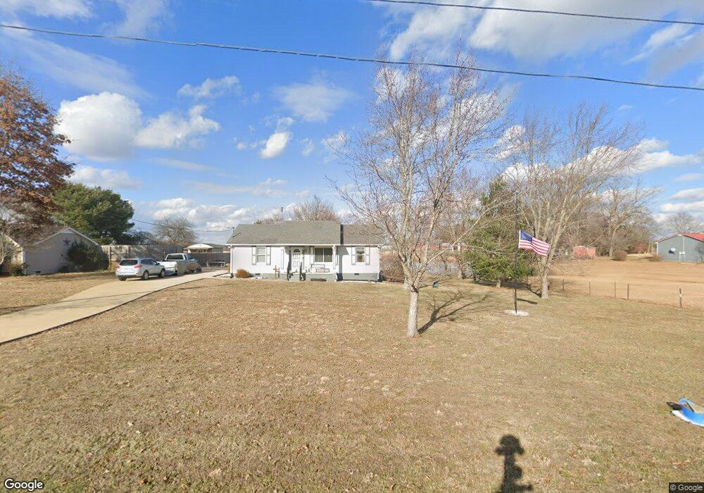
6126 Cook Rd Orlinda, TN 37141
Estimated Value: $201,524 - $288,000
--
Bed
2
Baths
1,056
Sq Ft
$246/Sq Ft
Est. Value
About This Home
This home is located at 6126 Cook Rd, Orlinda, TN 37141 and is currently estimated at $260,131, approximately $246 per square foot. 6126 Cook Rd is a home located in Robertson County with nearby schools including East Robertson Elementary School and East Robertson High School.
Ownership History
Date
Name
Owned For
Owner Type
Purchase Details
Closed on
Jun 9, 1998
Sold by
Groves Edwin A and Groves Linda J
Bought by
Groves Harold T and Groves Lanan C
Current Estimated Value
Purchase Details
Closed on
May 29, 1998
Sold by
Groves Edwin A and Groves Linda J
Bought by
Groves Edwin A and Groves Linda J
Purchase Details
Closed on
Mar 12, 1993
Bought by
Spurlock John T
Purchase Details
Closed on
Sep 25, 1991
Bought by
Westberry James A and Westberry June
Purchase Details
Closed on
Jun 12, 1991
Bought by
Mays Herbert
Purchase Details
Closed on
Oct 19, 1984
Bought by
Williams Billy Joe and Williams Dorothy
Create a Home Valuation Report for This Property
The Home Valuation Report is an in-depth analysis detailing your home's value as well as a comparison with similar homes in the area
Home Values in the Area
Average Home Value in this Area
Purchase History
| Date | Buyer | Sale Price | Title Company |
|---|---|---|---|
| Groves Harold T | $20,600 | -- | |
| Groves Edwin A | -- | -- | |
| Spurlock John T | $51,900 | -- | |
| Westberry James A | $42,000 | -- | |
| Mays Herbert | $7,000 | -- | |
| Williams Billy Joe | -- | -- |
Source: Public Records
Tax History Compared to Growth
Tax History
| Year | Tax Paid | Tax Assessment Tax Assessment Total Assessment is a certain percentage of the fair market value that is determined by local assessors to be the total taxable value of land and additions on the property. | Land | Improvement |
|---|---|---|---|---|
| 2024 | $774 | $42,975 | $9,350 | $33,625 |
| 2023 | $774 | $42,975 | $9,350 | $33,625 |
| 2022 | $737 | $28,600 | $3,400 | $25,200 |
| 2021 | $737 | $28,600 | $3,400 | $25,200 |
| 2020 | $737 | $28,600 | $3,400 | $25,200 |
| 2019 | $737 | $28,600 | $3,400 | $25,200 |
| 2018 | $737 | $28,600 | $3,400 | $25,200 |
| 2017 | $707 | $22,925 | $4,950 | $17,975 |
| 2016 | $707 | $22,925 | $4,950 | $17,975 |
| 2015 | $679 | $22,925 | $4,950 | $17,975 |
| 2014 | $639 | $21,575 | $4,950 | $16,625 |
Source: Public Records
Map
Nearby Homes
- 6016 Highland Rd
- 6070 Cook Rd
- 8283 Highway 52
- 0 Payne Rd Extension Unit RTC2898325
- 0 State Route 52
- 0 Red River School Rd Unit RTC3003481
- 0 Red River School Rd Unit RTC2922826
- 6485 Highland Rd
- 8637 Tennessee 52
- 8657 Highway 52
- 0 Hulsey Rd
- 0 Bill Anderson Rd
- 5373 E Robertson Rd
- 8044 Pleasant Hill Rd
- 8127 Pleasant Hill Rd
- 0 Jimson Rd
- 5178 E Robertson Rd
- 2671 Friendship Rd
- 8302 Springfield Rd
- 6143 Price Rd