
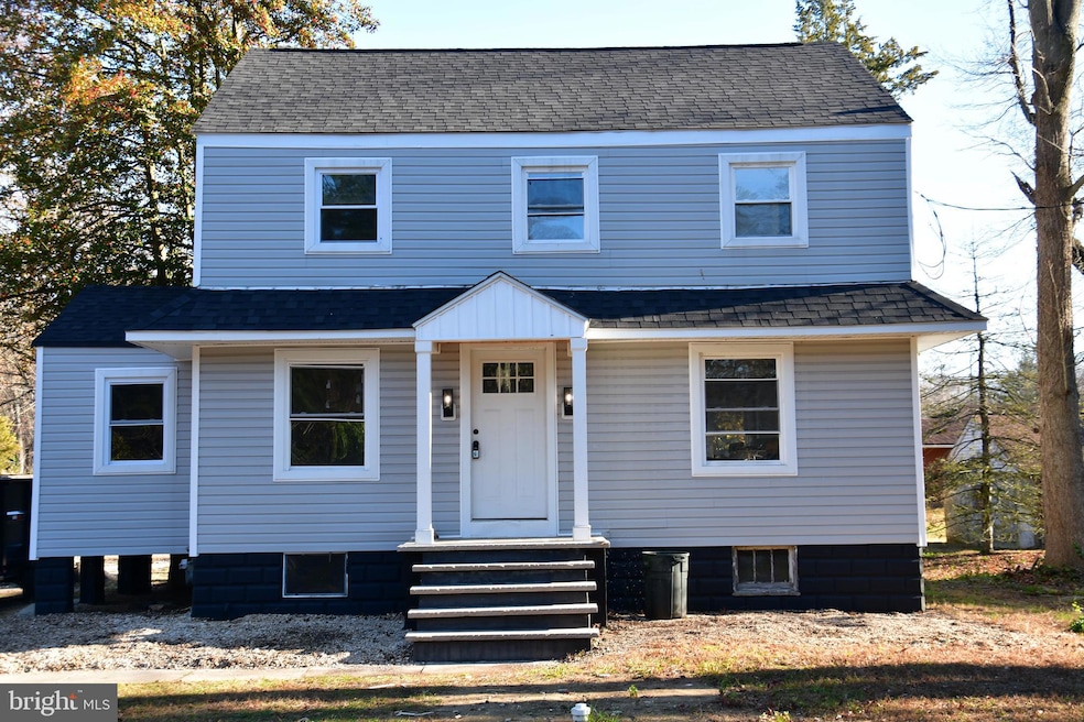
613 Hawks Bridge Rd Penns Grove, NJ 08069
Estimated payment $2,238/month
3
Beds
1.5
Baths
1,427
Sq Ft
0.33
Acres
Highlights
- Open Floorplan
- Attic
- Breakfast Area or Nook
- Colonial Architecture
- No HOA
- Chair Railings
About This Home
Coming Soon! Step inside this beautifully renovated Colonial style home that truly feels brand new from top to bottom. Thoughtfully updated with modern comforts and timeless charm, this 3 bedroom, 1.5 bath property is the perfect blend of style, function, and peace of mind. Step into the extra spacious living room, featuring elegant wainscoting and plenty of space for gatherings, relaxation, or entertaining. The all-new kitchen shines with fresh finishes and updated design, making meal prep feel effortless and enjoyable. This home has undergone an extensive renovation with more to come. Brand new HVAC, roof, electric & plumbing, insulation, drywall and paint, fully updated bathrooms, modernized kitchen and so much more. If you're seeking a move-in-ready home with major upgrades already complete, this is the one you won’t want to miss. Showings expected to begin around December 12th.
Listing Agent
(856) 275-3737 christy@christymyersgroup.com American Dream Realty of South Jersey License #1649390 Listed on: 11/28/2025
Home Details
Home Type
- Single Family
Est. Annual Taxes
- $4,757
Year Built
- Built in 1938 | Remodeled in 2025
Lot Details
- 0.33 Acre Lot
- Lot Dimensions are 80.00 x 177.00
- Property is in excellent condition
Parking
- Driveway
Home Design
- Colonial Architecture
- Shingle Roof
- Shingle Siding
Interior Spaces
- 1,427 Sq Ft Home
- Property has 2 Levels
- Open Floorplan
- Chair Railings
- Wainscoting
- Combination Dining and Living Room
- Attic
Kitchen
- Breakfast Area or Nook
- Eat-In Kitchen
- Electric Oven or Range
- Built-In Microwave
- Dishwasher
Flooring
- Carpet
- Luxury Vinyl Plank Tile
Bedrooms and Bathrooms
- 3 Bedrooms
- Bathtub with Shower
Laundry
- Laundry on lower level
- Washer and Dryer Hookup
Basement
- Partial Basement
- Crawl Space
Utilities
- 90% Forced Air Heating and Cooling System
- 200+ Amp Service
- Well
- Natural Gas Water Heater
- On Site Septic
Community Details
- No Home Owners Association
- Cedar Crest Subdivision
Listing and Financial Details
- Coming Soon on 12/12/25
- Tax Lot 00008
- Assessor Parcel Number 02-00260-00008
Map
Create a Home Valuation Report for This Property
The Home Valuation Report is an in-depth analysis detailing your home's value as well as a comparison with similar homes in the area
Home Values in the Area
Average Home Value in this Area
Tax History
| Year | Tax Paid | Tax Assessment Tax Assessment Total Assessment is a certain percentage of the fair market value that is determined by local assessors to be the total taxable value of land and additions on the property. | Land | Improvement |
|---|---|---|---|---|
| 2025 | $2,393 | $197,400 | $37,400 | $160,000 |
| 2024 | $2,310 | $64,900 | $17,300 | $47,600 |
| 2023 | $2,310 | $64,900 | $17,300 | $47,600 |
| 2022 | $2,174 | $64,900 | $17,300 | $47,600 |
| 2021 | $2,153 | $64,900 | $17,300 | $47,600 |
| 2020 | $5,241 | $156,600 | $34,600 | $122,000 |
| 2019 | $5,292 | $156,800 | $34,600 | $122,200 |
| 2018 | $4,613 | $146,500 | $34,100 | $112,400 |
| 2017 | $4,301 | $146,500 | $34,100 | $112,400 |
| 2016 | $4,144 | $146,500 | $34,100 | $112,400 |
| 2015 | $3,951 | $146,500 | $34,100 | $112,400 |
| 2014 | $3,740 | $146,500 | $34,100 | $112,400 |
Source: Public Records
Purchase History
| Date | Type | Sale Price | Title Company |
|---|---|---|---|
| Deed | $115,000 | West Jersey Title | |
| Deed | $115,000 | West Jersey Title | |
| Executors Deed | $20,000 | None Available |
Source: Public Records
Mortgage History
| Date | Status | Loan Amount | Loan Type |
|---|---|---|---|
| Closed | $210,000 | Balloon |
Source: Public Records
About the Listing Agent
As a dedicated South Jersey REALTOR® with a genuine passion for helping people achieve their real estate dreams, I prioritize truly understanding each client’s goals from day one. Whether you’re searching for your first home, preparing to sell, or exploring an investment, my mission is to provide the highest level of professional service while making the process feel clear, supported, and as stress-free as possible.
From the very first showing to the moment we sit together at settlement—and
Christy's Other Listings
Source: Bright MLS
MLS Number: NJSA2017346
APN: 02-00260-0000-00008
Disclaimer: Certain information contained herein is derived from information provided by parties other than Homes.com. All information provided is deemed reliable, but is not guaranteed to be accurate and should be independently verified.
![]() The data relating to real estate for sale on this website appears in part through the BRIGHT Internet Data Exchange program, a voluntary cooperative exchange of property listing data between licensed real estate brokerage firms, and is provided by BRIGHT through a licensing agreement.
The data relating to real estate for sale on this website appears in part through the BRIGHT Internet Data Exchange program, a voluntary cooperative exchange of property listing data between licensed real estate brokerage firms, and is provided by BRIGHT through a licensing agreement.
Listing information is from various brokers who participate in the Bright MLS IDX program and not all listings may be visible on the site.
The property information being provided on or through the website is for the personal, non-commercial use of consumers and such information may not be used for any purpose other than to identify prospective properties consumers may be interested in purchasing.
Some properties which appear for sale on the website may no longer be available because they are for instance, under contract, sold or are no longer being offered for sale.
Property information displayed is deemed reliable but is not guaranteed.
Copyright 2025 Bright MLS, Inc.
Nearby Homes
- 604 Hawks Bridge Rd
- 371 Route 40
- 370 Route 40
- 371 40 Route
- 613 Soders Rd
- 1 Victory Ave Unit 82
- 1 Victory Ave Unit 74
- 1 Victory Ave Unit 72
- 1 Victory Ave Unit 8
- 1 Victory Ave Unit 93
- 1 Victory Ave Unit 55
- 1 Victory Ave Unit 56
- 1 Victory Ave Unit 22
- 29 Chester Ave
- 62 Penns Ave
- 12 Chester Ave
- 16 Pine St
- 17 King St
- 5 Harrison St
- 17 Sportsman Rd
- 12 Meadow Rd
- 113 N Hook Rd
- 178 N Broadway
- 37 Beaver Ave
- 294 Merion Ave
- 130 130 N Broadway Unit 2
- 277 Jefferson St
- 266 Apt B2 Shell Rd
- 254 G St
- 81 S Broadway
- 50 Chestnut St Unit B
- 1000 Carroll Ave
- 109 111 State St
- 542 S Broadway
- 39 Elvin Ave
- 72 Delaware Ave
- 104 Delaware Dr
- 40 Rose Ln
- 310 N Broad St
- 344 N Virginia Ave