Estimated Value: $282,610 - $329,000
3
Beds
2
Baths
1,180
Sq Ft
$253/Sq Ft
Est. Value
About This Home
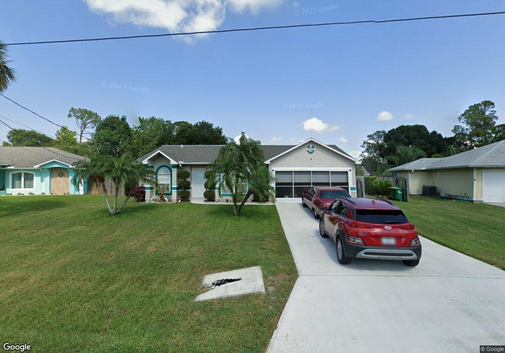
This home is located at 6153 Dees Rd, Cocoa, FL 32927 and is currently estimated at $298,653, approximately $253 per square foot. 6153 Dees Rd is a home located in Brevard County with nearby schools including Enterprise Elementary School, Space Coast Junior/Senior High School, and East Atlantic Prep of Brevard County.
Ownership History
Date
Name
Owned For
Owner Type
Purchase Details
Closed on
Feb 28, 2002
Sold by
Ramsey Robert J and Ramsey Shannon R
Bought by
Degel Michael A
Current Estimated Value
Home Financials for this Owner
Home Financials are based on the most recent Mortgage that was taken out on this home.
Original Mortgage
$87,000
Outstanding Balance
$35,702
Interest Rate
6.81%
Estimated Equity
$262,951
Create a Home Valuation Report for This Property
The Home Valuation Report is an in-depth analysis detailing your home's value as well as a comparison with similar homes in the area
Home Values in the Area
Average Home Value in this Area
Purchase History
| Date | Buyer | Sale Price | Title Company |
|---|---|---|---|
| Degel Michael A | $87,000 | -- |
Source: Public Records
Mortgage History
| Date | Status | Borrower | Loan Amount |
|---|---|---|---|
| Open | Degel Michael A | $87,000 |
Source: Public Records
Tax History
| Year | Tax Paid | Tax Assessment Tax Assessment Total Assessment is a certain percentage of the fair market value that is determined by local assessors to be the total taxable value of land and additions on the property. | Land | Improvement |
|---|---|---|---|---|
| 2025 | $1,128 | $84,490 | -- | -- |
| 2024 | $1,094 | $82,110 | -- | -- |
| 2023 | $1,094 | $79,720 | $0 | $0 |
| 2022 | $1,015 | $77,400 | $0 | $0 |
| 2021 | $1,003 | $75,150 | $0 | $0 |
| 2020 | $956 | $74,120 | $0 | $0 |
| 2019 | $904 | $72,460 | $0 | $0 |
| 2018 | $905 | $71,110 | $0 | $0 |
| 2017 | $907 | $69,650 | $0 | $0 |
| 2016 | $916 | $68,220 | $18,000 | $50,220 |
| 2015 | $925 | $67,750 | $15,000 | $52,750 |
| 2014 | $929 | $67,220 | $11,000 | $56,220 |
Source: Public Records
Map
Nearby Homes
- 6200 Edison St
- 6150 Baltimore Ave
- 6085 Edison St
- 00000 Golfview Ave
- 6230 Balsam St
- 6010 Fay Blvd
- 6180 Balboa St
- 0 Golfview Ave
- 6220 Golfview Ave
- 6215 Balboa St
- 23-35-21-J No Name
- 6120 Adele St
- 5812 Homestead Ave
- 6365 Homestead Ave
- 23-35-21-JX-B-2 Aruin St
- 6510 Aspen Ln
- 6470 Bamboo Ave
- 5720 Flint Rd
- 6545 Addie Ave
- 6177 Brandt St
Your Personal Tour Guide
Ask me questions while you tour the home.