Estimated Value: $1,064,842 - $1,264,000
--
Bed
--
Bath
2,749
Sq Ft
$423/Sq Ft
Est. Value
About This Home
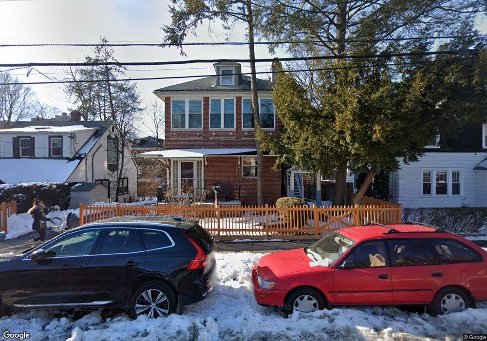
This home is located at 6155 Tyndall Ave, Bronx, NY 10471 and is currently estimated at $1,162,461, approximately $422 per square foot. 6155 Tyndall Ave is a home located in Bronx County with nearby schools including P.S. 81 - Robert J. Christen, Riverdale Kingsbridge Academy, and St Margaret Of Cortona School.
Ownership History
Date
Name
Owned For
Owner Type
Purchase Details
Closed on
Apr 4, 2002
Sold by
Gleeson Martin and Gleeson Mary
Bought by
Guy Browner-Elhanan Karen and Guy Elhanan
Current Estimated Value
Home Financials for this Owner
Home Financials are based on the most recent Mortgage that was taken out on this home.
Original Mortgage
$350,000
Interest Rate
6.73%
Create a Home Valuation Report for This Property
The Home Valuation Report is an in-depth analysis detailing your home's value as well as a comparison with similar homes in the area
Home Values in the Area
Average Home Value in this Area
Purchase History
| Date | Buyer | Sale Price | Title Company |
|---|---|---|---|
| Guy Browner-Elhanan Karen | -- | -- |
Source: Public Records
Mortgage History
| Date | Status | Borrower | Loan Amount |
|---|---|---|---|
| Previous Owner | Guy Browner-Elhanan Karen | $350,000 |
Source: Public Records
Tax History Compared to Growth
Tax History
| Year | Tax Paid | Tax Assessment Tax Assessment Total Assessment is a certain percentage of the fair market value that is determined by local assessors to be the total taxable value of land and additions on the property. | Land | Improvement |
|---|---|---|---|---|
| 2025 | $10,325 | $54,432 | $9,882 | $44,550 |
| 2024 | $10,325 | $51,408 | $10,746 | $40,662 |
| 2023 | $10,440 | $51,408 | $12,520 | $38,888 |
| 2022 | $10,174 | $59,160 | $14,160 | $45,000 |
| 2021 | $10,119 | $56,580 | $14,160 | $42,420 |
| 2020 | $9,601 | $62,160 | $14,160 | $48,000 |
| 2019 | $8,962 | $64,080 | $14,160 | $49,920 |
| 2018 | $8,733 | $42,840 | $8,088 | $34,752 |
| 2017 | $8,658 | $42,472 | $11,027 | $31,445 |
| 2016 | $8,010 | $40,068 | $12,249 | $27,819 |
| 2015 | $5,280 | $37,800 | $15,720 | $22,080 |
| 2014 | $5,280 | $35,700 | $15,720 | $19,980 |
Source: Public Records
Map
Nearby Homes
- 6133 Fieldston Rd
- 351 W 262nd St
- 315 W 262nd St
- 6112 Fieldston Rd
- 6140 Delafield Ave
- 6141 Delafield Ave
- 6036 Liebig Ave
- 6200 Riverdale Ave Unit 3K
- 6033A Huxley Ave
- 6300 Riverdale Ave Unit 1B
- 6300 Riverdale Ave Unit 5C
- 6300 Riverdale Ave Unit 5E
- 5930 Tyndall Ave
- 143 Bruce Ave Unit 7A
- 227 W 260th St
- 5926 Spencer Ave
- 568-L W 261st St
- 204 W 260th St
- 305 W 259th St
- 21 Pershing Ave
- 6157 Tyndall Ave
- 6151 Tyndall Ave
- 6161 Tyndall Ave
- 6141 Tyndall Ave
- 6148 Liebig Ave
- 6146 Liebig Ave
- 6144 Liebig Ave
- 6150 Liebig Ave
- 6163 Tyndall Ave
- 6142 Liebig Ave
- 6152 Liebig Ave
- 6152 Liebig Ave Unit 1
- 6140 Liebig Ave
- 6154 Liebig Ave
- 6138 Liebig Ave
- 6200 Tyndall Ave
- 370 W 262nd St
- 370 W 262nd St Unit 1
- 370 W 262nd St Unit Building
- 6136 Liebig Ave