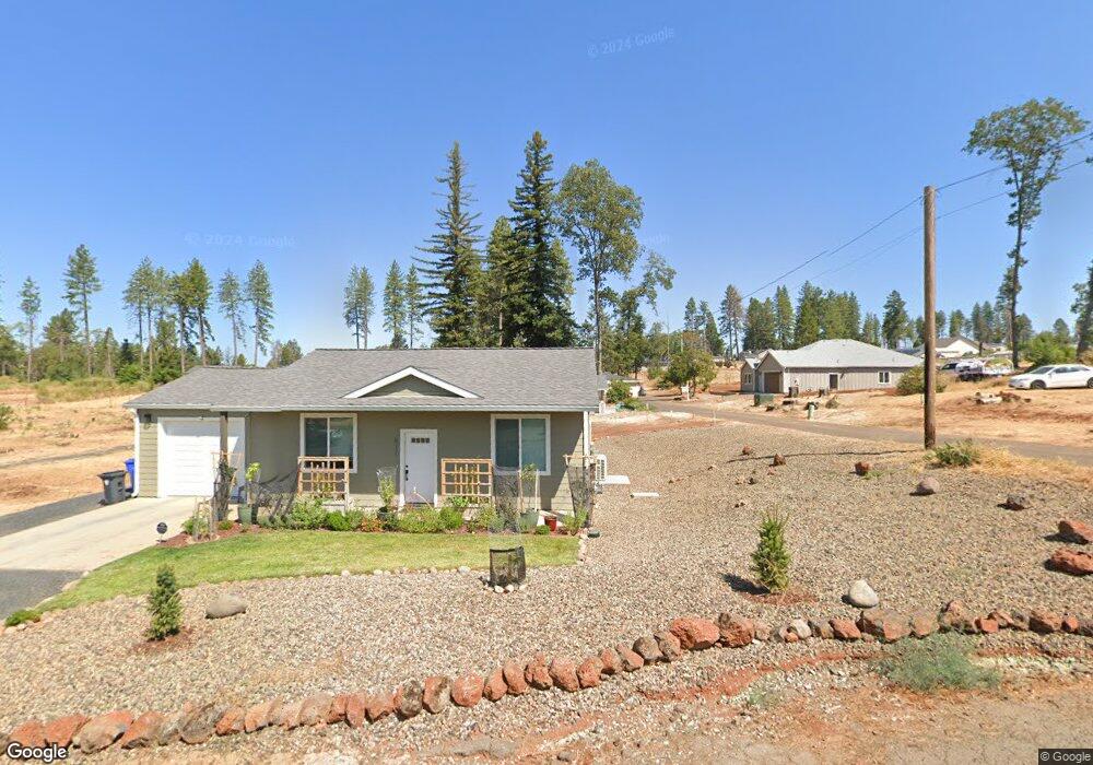
6159 Lois Dr Paradise, CA 95969
Estimated Value: $234,000 - $305,000
2
Beds
1
Bath
1,002
Sq Ft
$275/Sq Ft
Est. Value
About This Home
This home is located at 6159 Lois Dr, Paradise, CA 95969 and is currently estimated at $275,884, approximately $275 per square foot. 6159 Lois Dr is a home with nearby schools including Paradise Junior High School, Paradise Senior High School, and Hometech Charter School.
Ownership History
Date
Name
Owned For
Owner Type
Purchase Details
Closed on
Feb 23, 2021
Sold by
Heaton Marianne
Bought by
Heaton Marianne
Current Estimated Value
Purchase Details
Closed on
Oct 29, 2001
Sold by
Hoover Francis J and Hoover Lois J
Bought by
Heaton Marianne
Home Financials for this Owner
Home Financials are based on the most recent Mortgage that was taken out on this home.
Original Mortgage
$101,500
Outstanding Balance
$39,700
Interest Rate
6.73%
Mortgage Type
FHA
Estimated Equity
$236,184
Create a Home Valuation Report for This Property
The Home Valuation Report is an in-depth analysis detailing your home's value as well as a comparison with similar homes in the area
Home Values in the Area
Average Home Value in this Area
Purchase History
| Date | Buyer | Sale Price | Title Company |
|---|---|---|---|
| Heaton Marianne | -- | None Available | |
| Heaton Marianne | $102,500 | Fidelity National Title |
Source: Public Records
Mortgage History
| Date | Status | Borrower | Loan Amount |
|---|---|---|---|
| Open | Heaton Marianne | $101,500 |
Source: Public Records
Tax History
| Year | Tax Paid | Tax Assessment Tax Assessment Total Assessment is a certain percentage of the fair market value that is determined by local assessors to be the total taxable value of land and additions on the property. | Land | Improvement |
|---|---|---|---|---|
| 2025 | $1,341 | $129,985 | $51,691 | $78,294 |
| 2024 | $1,341 | $127,437 | $50,678 | $76,759 |
| 2023 | $1,339 | $124,939 | $49,685 | $75,254 |
| 2022 | $1,312 | $122,490 | $48,711 | $73,779 |
| 2021 | $1,283 | $120,089 | $47,756 | $72,333 |
| 2020 | $236 | $25,000 | $25,000 | $0 |
| 2019 | $288 | $30,000 | $30,000 | $0 |
| 2018 | $1,168 | $114,238 | $45,433 | $68,805 |
| 2017 | $1,150 | $111,999 | $44,543 | $67,456 |
| 2016 | $1,111 | $109,804 | $43,670 | $66,134 |
| 2015 | $1,093 | $108,156 | $43,015 | $65,141 |
| 2014 | $963 | $95,000 | $55,000 | $40,000 |
Source: Public Records
Map
Nearby Homes
- 600 Bille Rd
- 6096 Oliver Rd
- 676 Edwards Ln
- 665 Brookhaven Dr
- 538 Castle Dr
- 585 Valley View Dr
- 726 Edwards Ln
- 722 Madrone Way
- 707 Madrone Way
- 732 Madrone Way
- 717 Madrone Way
- 661 Dogwood Ln
- 6020 Crestview Dr
- 711 Camellia Dr
- 6112 Ripley Ln
- 750 Brookhaven Dr
- 6148 Ripley Ln
- 790 Bille Rd
- 814 Camellia Dr
- 6092 Cliff Dr
Your Personal Tour Guide
Ask me questions while you tour the home.