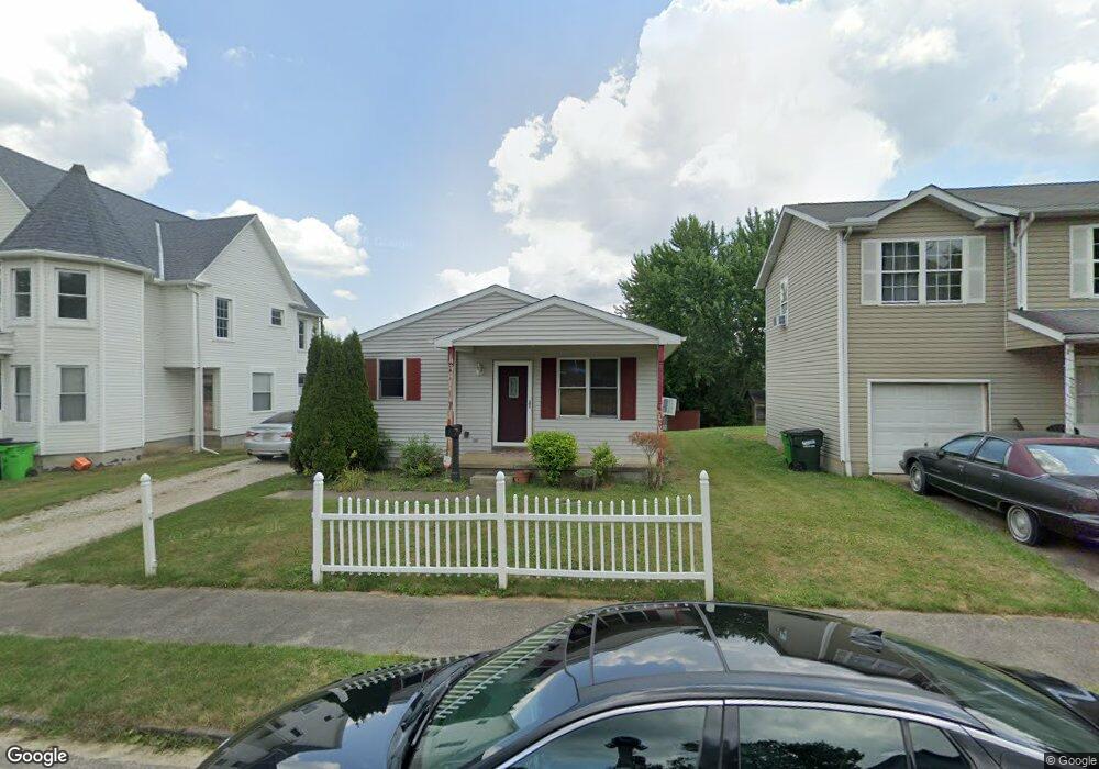
616 S Seneca Ave Alliance, OH 44601
Estimated Value: $46,000 - $102,000
3
Beds
1
Bath
1,040
Sq Ft
$82/Sq Ft
Est. Value
About This Home
This home is located at 616 S Seneca Ave, Alliance, OH 44601 and is currently estimated at $84,992, approximately $81 per square foot. 616 S Seneca Ave is a home located in Stark County with nearby schools including Alliance Intermediate School at Northside, Alliance Elementary School at Rockhill, and Alliance Middle School.
Ownership History
Date
Name
Owned For
Owner Type
Purchase Details
Closed on
Dec 2, 1999
Sold by
Alliance Area Habitat For Humanity
Bought by
Young Don Alvin and Young Tearna Rowena
Current Estimated Value
Home Financials for this Owner
Home Financials are based on the most recent Mortgage that was taken out on this home.
Original Mortgage
$39,985
Interest Rate
7.97%
Mortgage Type
Seller Take Back
Create a Home Valuation Report for This Property
The Home Valuation Report is an in-depth analysis detailing your home's value as well as a comparison with similar homes in the area
Home Values in the Area
Average Home Value in this Area
Purchase History
| Date | Buyer | Sale Price | Title Company |
|---|---|---|---|
| Young Don Alvin | $41,300 | Union Title Company |
Source: Public Records
Mortgage History
| Date | Status | Borrower | Loan Amount |
|---|---|---|---|
| Closed | Young Don Alvin | $39,985 | |
| Closed | Young Don Alvin | $10,000 |
Source: Public Records
Tax History
| Year | Tax Paid | Tax Assessment Tax Assessment Total Assessment is a certain percentage of the fair market value that is determined by local assessors to be the total taxable value of land and additions on the property. | Land | Improvement |
|---|---|---|---|---|
| 2025 | $443 | $22,300 | $3,680 | $18,620 |
| 2024 | -- | $22,300 | $3,680 | $18,620 |
| 2023 | $736 | $18,310 | $1,890 | $16,420 |
| 2022 | $741 | $18,310 | $1,890 | $16,420 |
| 2021 | $741 | $18,310 | $1,890 | $16,420 |
| 2020 | $691 | $15,930 | $1,650 | $14,280 |
| 2019 | $681 | $15,370 | $1,650 | $13,720 |
Source: Public Records
Map
Nearby Homes
- 442 S Liberty Ave
- 452 E Summit St
- V/L S Freedom Ave
- 955 E Summit St
- 726 S Arch Ave
- 935 S Morgan Ave
- 234 Rosenberry St
- 231 Rosenberry St
- 361 E Main St
- 226 Milner St
- 62 E High St
- 0 E Oxford St
- 847 E Patterson St
- 46 Rosenberry St
- 427 S Union Ave
- 167 11th St
- 134 11th St
- 807 S Union Ave
- 62 E Market St
- 1350 S Freedom Ave
- 604 S Seneca Ave
- 628 S Seneca Ave
- 638 S Seneca Ave
- 617 S Liberty Ave
- 625 S Liberty Ave
- 625 S Liberty Ave
- 548 S Seneca Ave
- 627 S Liberty Ave
- 648 S Seneca Ave
- 627 S Seneca Ave
- 533 E Cambridge St
- 536 S Seneca Ave
- 549 S Liberty Ave
- 543 S Seneca Ave
- 656 S Seneca Ave
- 46163 E Cambridge St
- 647 S Seneca Ave
- 531 S Seneca Ave
- 612 S Liberty Ave
- 638 S Liberty Ave
Your Personal Tour Guide
Ask me questions while you tour the home.