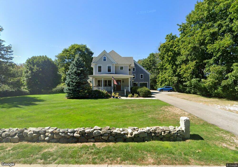
617 Central Rd Rye Beach, NH 03871
Estimated Value: $2,957,593 - $4,593,000
5
Beds
4
Baths
4,189
Sq Ft
$921/Sq Ft
Est. Value
About This Home
This home is located at 617 Central Rd, Rye Beach, NH 03871 and is currently estimated at $3,858,531, approximately $921 per square foot. 617 Central Rd is a home located in Rockingham County with nearby schools including Rye Elementary School, Rye Junior High School, and Rye Country Day School.
Ownership History
Date
Name
Owned For
Owner Type
Purchase Details
Closed on
Jun 10, 2014
Sold by
Brandon Kevin J and Brandon Denice A
Bought by
Denice A Brandon Ret
Current Estimated Value
Purchase Details
Closed on
Dec 20, 2005
Sold by
Nora C Blouin T
Bought by
North Shore Props Llc
Home Financials for this Owner
Home Financials are based on the most recent Mortgage that was taken out on this home.
Original Mortgage
$800,000
Interest Rate
6.34%
Create a Home Valuation Report for This Property
The Home Valuation Report is an in-depth analysis detailing your home's value as well as a comparison with similar homes in the area
Home Values in the Area
Average Home Value in this Area
Purchase History
| Date | Buyer | Sale Price | Title Company |
|---|---|---|---|
| Denice A Brandon Ret | -- | -- | |
| North Shore Props Llc | $100,000 | -- |
Source: Public Records
Mortgage History
| Date | Status | Borrower | Loan Amount |
|---|---|---|---|
| Previous Owner | North Shore Props Llc | $800,000 |
Source: Public Records
Tax History
| Year | Tax Paid | Tax Assessment Tax Assessment Total Assessment is a certain percentage of the fair market value that is determined by local assessors to be the total taxable value of land and additions on the property. | Land | Improvement |
|---|---|---|---|---|
| 2024 | $19,663 | $2,270,600 | $610,900 | $1,659,700 |
| 2023 | $18,233 | $2,270,600 | $610,900 | $1,659,700 |
| 2022 | $15,849 | $2,270,600 | $610,900 | $1,659,700 |
| 2021 | $17,044 | $1,667,700 | $354,300 | $1,313,400 |
| 2020 | $17,044 | $1,667,700 | $354,300 | $1,313,400 |
| 2019 | $17,044 | $1,667,700 | $354,300 | $1,313,400 |
| 2018 | $16,998 | $1,667,300 | $354,300 | $1,313,000 |
| 2017 | $16,856 | $1,667,300 | $354,300 | $1,313,000 |
| 2016 | $10,401 | $1,627,800 | $321,900 | $1,305,900 |
| 2015 | $17,743 | $1,627,800 | $321,900 | $1,305,900 |
| 2013 | $17,857 | $1,627,800 | $321,900 | $1,305,900 |
Source: Public Records
Map
Nearby Homes
- 611 Central Rd
- 605 Central Rd
- 620 Central Rd
- 626 Central Rd
- 595 Central Rd
- 616 Central Rd
- 630 Central Rd
- 166 Perkins Rd
- 636 Central Rd
- 587 Central Rd
- 159 Perkins Rd
- 586 Central Rd
- 640 Central Rd
- 156 Perkins Rd
- 610 Central Rd
- 153 Perkins Rd
- 655 Central Rd
- 8 Mclaughlin Dr
- 650 Central Rd
- 149 Perkins Rd
Your Personal Tour Guide
Ask me questions while you tour the home.