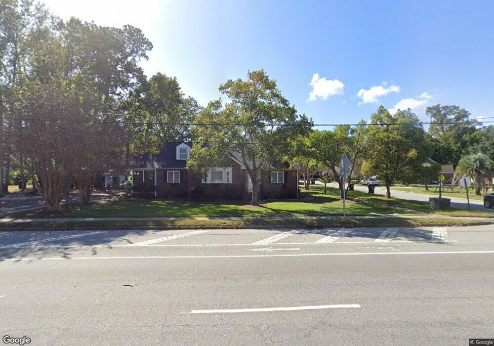
617 Saint Andrews Blvd Charleston, SC 29407
Avondale NeighborhoodEstimated Value: $503,000 - $1,002,000
4
Beds
3
Baths
2,270
Sq Ft
$368/Sq Ft
Est. Value
About This Home
This home is located at 617 Saint Andrews Blvd, Charleston, SC 29407 and is currently estimated at $835,533, approximately $368 per square foot. 617 Saint Andrews Blvd is a home located in Charleston County with nearby schools including St. Andrews School Of Math And Science, West Ashley High School, and Blessed Sacrament Catholic School.
Ownership History
Date
Name
Owned For
Owner Type
Purchase Details
Closed on
Dec 22, 2021
Sold by
Rjk Llc
Bought by
Stecklein Michelle
Current Estimated Value
Home Financials for this Owner
Home Financials are based on the most recent Mortgage that was taken out on this home.
Original Mortgage
$250,000
Outstanding Balance
$121,137
Interest Rate
3.11%
Mortgage Type
Seller Take Back
Estimated Equity
$714,396
Purchase Details
Closed on
Aug 3, 2012
Sold by
Wham J W and Wham J
Bought by
R J K Llc
Create a Home Valuation Report for This Property
The Home Valuation Report is an in-depth analysis detailing your home's value as well as a comparison with similar homes in the area
Home Values in the Area
Average Home Value in this Area
Purchase History
| Date | Buyer | Sale Price | Title Company |
|---|---|---|---|
| Stecklein Michelle | $250,000 | None Listed On Document | |
| R J K Llc | -- | -- |
Source: Public Records
Mortgage History
| Date | Status | Borrower | Loan Amount |
|---|---|---|---|
| Open | Stecklein Michelle | $250,000 |
Source: Public Records
Tax History Compared to Growth
Tax History
| Year | Tax Paid | Tax Assessment Tax Assessment Total Assessment is a certain percentage of the fair market value that is determined by local assessors to be the total taxable value of land and additions on the property. | Land | Improvement |
|---|---|---|---|---|
| 2024 | $1,927 | $14,400 | $0 | $0 |
| 2023 | $1,927 | $14,400 | $0 | $0 |
| 2022 | $1,786 | $14,400 | $0 | $0 |
| 2021 | $5,234 | $19,690 | $0 | $0 |
| 2020 | $5,196 | $19,690 | $0 | $0 |
| 2019 | $4,746 | $17,110 | $0 | $0 |
| 2017 | $4,535 | $17,110 | $0 | $0 |
| 2016 | $4,388 | $17,110 | $0 | $0 |
| 2015 | $4,190 | $17,110 | $0 | $0 |
| 2014 | $3,960 | $0 | $0 | $0 |
| 2011 | -- | $0 | $0 | $0 |
Source: Public Records
Map
Nearby Homes
- 715 Parish Rd
- 718 Parish Rd
- 867 Colony Dr Unit F92
- 874 Colony Dr Unit B19
- 870 Colony Dr Unit 2
- 834 Sheldon Rd
- 549 Godfrey Park Place
- 12 Stratford Rd
- 9 Campbell Dr
- 687 Savannah Hwy
- 699 Savannah Hwy
- 33 Yeadon Ave
- 19 Avondale Ave
- 18 Lyttleton Ave
- 103 Tall Oak Ave
- 10 Lyttleton Ave
- 48 Avondale Ave
- 212 Magnolia Rd
- 46 Chadwick Dr
- 3 Lord Ashley Dr
- 25 Moore Dr
- 23 Moore Dr
- 609 Saint Andrews Blvd
- 625 Saint Andrews Blvd
- 803 Saint Denis Dr
- 38 Moore Dr
- 804 Saint Dennis Dr
- 804 St Denis Dr
- 803 Saint Dennis Dr
- 717 Parish Rd
- 804 Saint Denis Dr
- 37 Moore Dr
- 608 Saint Andrews Blvd
- 35 Moore Dr
- 809 Saint Denis Dr
- 604 Saint Andrews Blvd
- 809 Saint Dennis Dr
- 36 Moore Dr
- 39 Moore Dr
- 19 Moore Dr