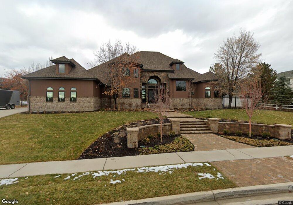
6174 Dry Creek Cir Highland, UT 84003
Estimated Value: $1,782,000 - $2,338,929
6
Beds
6
Baths
7,577
Sq Ft
$271/Sq Ft
Est. Value
About This Home
This home is located at 6174 Dry Creek Cir, Highland, UT 84003 and is currently estimated at $2,049,732, approximately $270 per square foot. 6174 Dry Creek Cir is a home located in Utah County with nearby schools including Ridgeline Elementary School, Timberline Middle School, and Lone Peak High School.
Ownership History
Date
Name
Owned For
Owner Type
Purchase Details
Closed on
Jun 13, 2019
Sold by
Landures Sheri
Bought by
The Deno And Sheri Landures Trust
Current Estimated Value
Purchase Details
Closed on
Jun 12, 2019
Sold by
Cano Pedro H and Cano Mary L
Bought by
Landures Sheri
Purchase Details
Closed on
Sep 23, 2010
Sold by
Stone Kenneth D and Stone Suzan E
Bought by
Wells Fargo Bank Na
Purchase Details
Closed on
Apr 12, 2006
Sold by
Stone Suzan E
Bought by
Stone Suzan E and Stone Kenneth D
Home Financials for this Owner
Home Financials are based on the most recent Mortgage that was taken out on this home.
Original Mortgage
$167,400
Interest Rate
6.2%
Mortgage Type
Credit Line Revolving
Purchase Details
Closed on
Dec 22, 2005
Sold by
Stone Kenneth D and Stone Suzan E
Bought by
Stone Suzan E
Home Financials for this Owner
Home Financials are based on the most recent Mortgage that was taken out on this home.
Original Mortgage
$70,000
Interest Rate
6.27%
Mortgage Type
Credit Line Revolving
Purchase Details
Closed on
Nov 10, 2004
Sold by
Stone Suzan E
Bought by
Stone Kenneth D and Stone Suzan E
Home Financials for this Owner
Home Financials are based on the most recent Mortgage that was taken out on this home.
Original Mortgage
$484,000
Interest Rate
7.15%
Mortgage Type
Purchase Money Mortgage
Purchase Details
Closed on
Nov 9, 2004
Sold by
Earnshaw Gregory M
Bought by
Stone Suzan E
Home Financials for this Owner
Home Financials are based on the most recent Mortgage that was taken out on this home.
Original Mortgage
$484,000
Interest Rate
7.15%
Mortgage Type
Purchase Money Mortgage
Purchase Details
Closed on
Sep 10, 2004
Sold by
Anthony Susan
Bought by
Earnshaw Gregory M
Home Financials for this Owner
Home Financials are based on the most recent Mortgage that was taken out on this home.
Original Mortgage
$484,000
Interest Rate
7.15%
Mortgage Type
Purchase Money Mortgage
Purchase Details
Closed on
Nov 16, 2000
Sold by
Earnshaw Gregory
Bought by
Earnshaw Gregory M
Home Financials for this Owner
Home Financials are based on the most recent Mortgage that was taken out on this home.
Original Mortgage
$420,000
Interest Rate
9%
Purchase Details
Closed on
Nov 10, 1999
Sold by
Stone Kenneth D
Bought by
Earnshaw Gregory
Home Financials for this Owner
Home Financials are based on the most recent Mortgage that was taken out on this home.
Original Mortgage
$400,000
Interest Rate
7.68%
Mortgage Type
Construction
Purchase Details
Closed on
Oct 15, 1998
Sold by
Dry Creek Estates L L C
Bought by
Stone Kenneth D
Create a Home Valuation Report for This Property
The Home Valuation Report is an in-depth analysis detailing your home's value as well as a comparison with similar homes in the area
Home Values in the Area
Average Home Value in this Area
Purchase History
| Date | Buyer | Sale Price | Title Company |
|---|---|---|---|
| The Deno And Sheri Landures Trust | -- | Artisan Title | |
| Landures Sheri | -- | Artisan Title | |
| Wells Fargo Bank Na | $610,219 | Etitle Insurance Agency | |
| Stone Suzan E | -- | Executive Title | |
| Stone Suzan E | -- | Fidelity Land & Title | |
| Stone Kenneth D | -- | Fidelity Land & Title | |
| Stone Suzan E | -- | Fidelity Land & Title | |
| Earnshaw Gregory M | -- | Fidelity Land & Title | |
| Earnshaw Gregory M | -- | Metro National Title | |
| Earnshaw Gregory | -- | Backman Stewart Title | |
| Stone Kenneth D | -- | -- |
Source: Public Records
Mortgage History
| Date | Status | Borrower | Loan Amount |
|---|---|---|---|
| Previous Owner | Stone Suzan E | $167,400 | |
| Previous Owner | Stone Suzan E | $70,000 | |
| Previous Owner | Stone Suzan E | $650,000 | |
| Previous Owner | Stone Suzan E | $484,000 | |
| Previous Owner | Earnshaw Gregory M | $420,000 | |
| Previous Owner | Earnshaw Gregory | $400,000 |
Source: Public Records
Tax History Compared to Growth
Tax History
| Year | Tax Paid | Tax Assessment Tax Assessment Total Assessment is a certain percentage of the fair market value that is determined by local assessors to be the total taxable value of land and additions on the property. | Land | Improvement |
|---|---|---|---|---|
| 2025 | $7,998 | $1,142,955 | $725,200 | $1,352,900 |
| 2024 | $6,628 | $987,910 | $0 | $0 |
| 2023 | $6,628 | $883,190 | $0 | $0 |
| 2022 | $6,185 | $799,095 | $0 | $0 |
| 2021 | $5,101 | $981,700 | $365,600 | $616,100 |
| 2020 | $4,854 | $916,100 | $317,900 | $598,200 |
| 2019 | $3,864 | $762,900 | $280,500 | $482,400 |
| 2018 | $4,066 | $762,900 | $280,500 | $482,400 |
| 2017 | $3,960 | $396,550 | $0 | $0 |
| 2016 | $4,065 | $380,435 | $0 | $0 |
| 2015 | $4,056 | $359,865 | $0 | $0 |
| 2014 | $3,617 | $318,065 | $0 | $0 |
Source: Public Records
Map
Nearby Homes
- 11248 Hawkstone Way Unit 109
- 6024 Hawkstone Way Unit 108
- 11228 Hawkstone Way Unit 110
- 11124 N 6000 W
- 6447 W Sunrise Dr
- 5798 W 11350 N
- 6602 W Normandy Way
- 11825 N 6260 W
- 11847 N Saltaire Dr
- 11572 N Maple Hollow Ct
- 11886 Harvest Moon Ln
- 5983 W 11270 N Unit 4
- 5976 W 11270 N Unit 5
- 6271 W 10830 St N
- Timpani Plan at Highland Oaks
- Ballad Plan at Highland Oaks
- Bravo Plan at Highland Oaks
- Fortissimo Plan at Highland Oaks
- Anthem Plan at Highland Oaks
- Forte Plan at Highland Oaks
- 6174 W Dry Creek Cir
- 6152 W Dry Creek Cir
- 6152 W Dry Creek Cir
- 6196 Dry Creek Cir
- 6181 W Dry Creek Cir
- 6179 W Bull River Rd
- 6159 W Dry Creek Cir
- 6159 Dry Creek Cir
- 6179 W Bull River Rd
- 6199 Bull River Rd
- 6199 W Bull River Rd
- 6195 W Dry Creek Cir
- 11441 N River Bend Rd
- 6118 W Dry Creek Cir
- 5900 11500 N Unit 4
- 6205 11500 N Unit 20
- 6218 11500 N Unit 22
- 6281 11500 N Unit 13
- 6259 11500 N Unit 15
- 6039 11500 N Unit 29