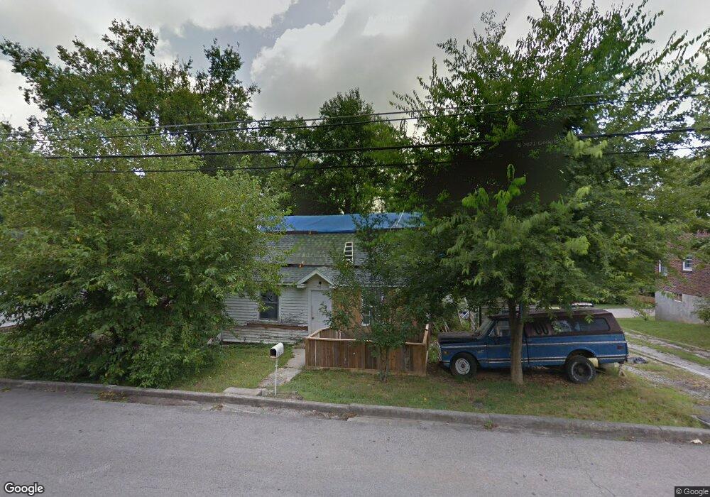
619 5th Ave N Lewisburg, TN 37091
Estimated Value: $78,939 - $153,000
--
Bed
1
Bath
798
Sq Ft
$157/Sq Ft
Est. Value
About This Home
This home is located at 619 5th Ave N, Lewisburg, TN 37091 and is currently estimated at $124,985, approximately $156 per square foot. 619 5th Ave N is a home located in Marshall County with nearby schools including Marshall Elementary School, Oak Grove Elementary School, and Westhills Elementary School.
Ownership History
Date
Name
Owned For
Owner Type
Purchase Details
Closed on
Oct 18, 1996
Sold by
Burl Colley
Bought by
Donald Welch
Current Estimated Value
Purchase Details
Closed on
Jul 15, 1995
Bought by
Colley Burl and Colley Linda
Purchase Details
Closed on
May 19, 1995
Bought by
Farmers Bank Of Cornersville Tn
Purchase Details
Closed on
Dec 22, 1994
Bought by
Robinson William Alton and Robinson Wanda Kay
Create a Home Valuation Report for This Property
The Home Valuation Report is an in-depth analysis detailing your home's value as well as a comparison with similar homes in the area
Home Values in the Area
Average Home Value in this Area
Purchase History
| Date | Buyer | Sale Price | Title Company |
|---|---|---|---|
| Donald Welch | $17,000 | -- | |
| Colley Burl | $13,500 | -- | |
| Farmers Bank Of Cornersville Tn | $13,200 | -- | |
| Robinson William Alton | $16,900 | -- |
Source: Public Records
Tax History Compared to Growth
Tax History
| Year | Tax Paid | Tax Assessment Tax Assessment Total Assessment is a certain percentage of the fair market value that is determined by local assessors to be the total taxable value of land and additions on the property. | Land | Improvement |
|---|---|---|---|---|
| 2024 | -- | $9,475 | $2,500 | $6,975 |
| 2023 | $294 | $9,475 | $2,500 | $6,975 |
| 2022 | $294 | $9,475 | $2,500 | $6,975 |
| 2021 | $229 | $4,925 | $1,250 | $3,675 |
| 2020 | $306 | $6,575 | $1,250 | $5,325 |
| 2019 | $296 | $6,575 | $1,250 | $5,325 |
| 2018 | $293 | $6,575 | $1,250 | $5,325 |
| 2017 | $293 | $6,575 | $1,250 | $5,325 |
| 2016 | $262 | $5,125 | $1,250 | $3,875 |
| 2015 | $239 | $5,125 | $1,250 | $3,875 |
| 2014 | $239 | $5,125 | $1,250 | $3,875 |
Source: Public Records
Map
Nearby Homes
- 594 5th Ave N
- 627 6th Ave N
- 630 6th Ave N
- 319 Greenwood St
- 231 Greenwood St
- 638 2nd Ave N
- 0 New Lake Rd Unit RTC3030964
- 726 Thomas Ave
- 543 2nd Ave N
- 316 Haynes St
- 416 1st Ave N
- 215 5th Ave N
- 1600 Larry Dospil Dr
- 518 Maple St
- 525 Maple St
- 319 E Hill Ave
- 610 Forrest St
- 1144 Apple St
- 1025 Glenn Ave
- 1111 W End Ave N
- 627 5th Ave N
- 613 5th Ave N
- 618 Limestone Ave
- 631 5th Ave N
- 624 Limestone Ave
- 616 5th Ave N
- 612 Limestone Ave
- 626 5th Ave N
- 0 Fifth Ave N Unit 1738457
- 632 N 5th Ave
- 595 5th Ave N
- 632 Limestone Ave
- 636 N 5th Ave
- 608 5th Ave N
- 604 Limestone Ave
- 634 N 5th Ave
- 639 5th Ave N
- 638 Limestone Ave
- 584 Limestone Ave
- 615 Limestone Ave