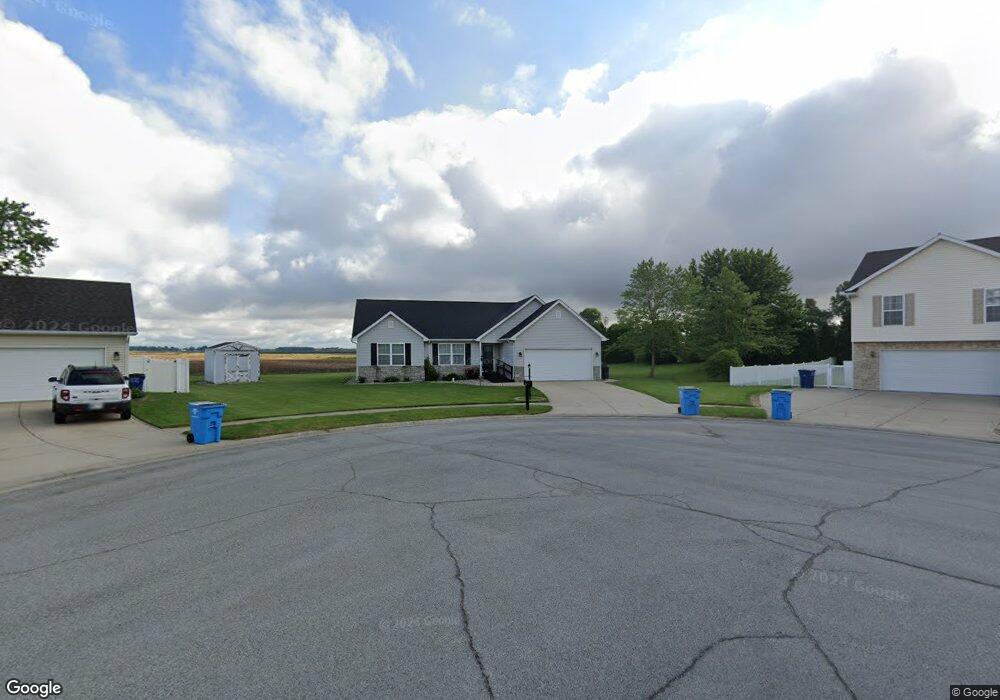
619 Fieldcrest Cir Wanatah, IN 46390
Estimated Value: $289,367 - $315,000
4
Beds
2
Baths
1,575
Sq Ft
$192/Sq Ft
Est. Value
About This Home
This home is located at 619 Fieldcrest Cir, Wanatah, IN 46390 and is currently estimated at $302,342, approximately $191 per square foot. 619 Fieldcrest Cir is a home located in LaPorte County with nearby schools including South Central Elementary School and South Central Junior/Senior High School.
Ownership History
Date
Name
Owned For
Owner Type
Purchase Details
Closed on
Oct 24, 2006
Sold by
Ultra Development Llc
Bought by
Weiss Christopher and Weiss Barbara
Current Estimated Value
Home Financials for this Owner
Home Financials are based on the most recent Mortgage that was taken out on this home.
Original Mortgage
$166,000
Outstanding Balance
$112,117
Interest Rate
8.99%
Mortgage Type
Unknown
Estimated Equity
$190,225
Purchase Details
Closed on
Jul 24, 2006
Sold by
Mitzner Marlene S
Bought by
Ultra Development Llc
Create a Home Valuation Report for This Property
The Home Valuation Report is an in-depth analysis detailing your home's value as well as a comparison with similar homes in the area
Home Values in the Area
Average Home Value in this Area
Purchase History
| Date | Buyer | Sale Price | Title Company |
|---|---|---|---|
| Weiss Christopher | -- | Ticor Title Insurance Co | |
| Ultra Development Llc | -- | Ticor Title Insurance Co |
Source: Public Records
Mortgage History
| Date | Status | Borrower | Loan Amount |
|---|---|---|---|
| Open | Weiss Christopher | $166,000 |
Source: Public Records
Tax History Compared to Growth
Tax History
| Year | Tax Paid | Tax Assessment Tax Assessment Total Assessment is a certain percentage of the fair market value that is determined by local assessors to be the total taxable value of land and additions on the property. | Land | Improvement |
|---|---|---|---|---|
| 2024 | $2,098 | $205,500 | $34,400 | $171,100 |
| 2022 | $1,751 | $189,000 | $34,400 | $154,600 |
| 2021 | $1,751 | $175,900 | $34,400 | $141,500 |
| 2020 | $1,768 | $175,900 | $34,400 | $141,500 |
| 2019 | $1,556 | $151,700 | $21,500 | $130,200 |
| 2018 | $1,661 | $159,800 | $21,500 | $138,300 |
| 2017 | $1,688 | $162,500 | $21,500 | $141,000 |
| 2016 | $1,696 | $163,400 | $21,500 | $141,900 |
| 2014 | $1,638 | $163,800 | $21,500 | $142,300 |
Source: Public Records
Map
Nearby Homes
- 627 Fieldcrest Cir
- 105 Earl St
- 116 Sprunger Dr
- 305 N Ohio St
- 104 W Cross St
- 106 N Illinois St Unit 266
- 207 N Washington St
- 0 W Hwy 30 Unit GNR545374
- 9552 S Bigelow Mill Rd
- 6465 W 1100 S
- W 800 S V L
- 627 E 300 S
- 83 Kaper Ln
- 87 Kaper Ln
- 421 Amy Rose Ln
- 0 Porters Vale Blvd Unit GNR544918
- 0 St Road 2 Unit GNR544911
- 168 Jamestown Ave
- 0 Parcel B 325 E
- 0 Parcel A 325 E
- 621 Fieldcrest Cir
- 617 Fieldcrest Cir
- 615 Fieldcrest Cir
- 623 Fieldcrest Cir
- 622 Fieldcrest Cir
- 613 Fieldcrest Cir
- 625 Fieldcrest Cir
- 624 Fieldcrest Cir
- 611 Fieldcrest Cir
- 606 Fieldcrest Cir
- 626 Fieldcrest Cir
- 626 Fieldcrest Cir Unit 3
- 604 Fieldcrest Cir
- 609 Fieldcrest Cir
- 602 Fieldcrest Cir
- 607 Fieldcrest Cir
- 605 Fieldcrest Cir
- 603 Fieldcrest Cir
- 510 Wildflower Way
- 501 Wildflower Way