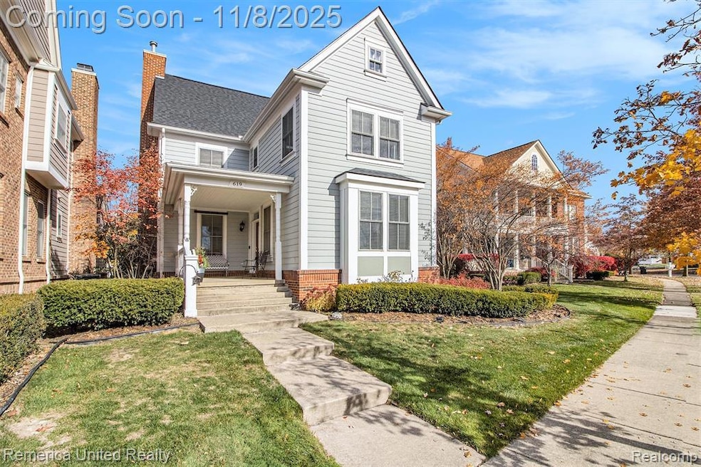
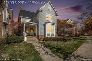
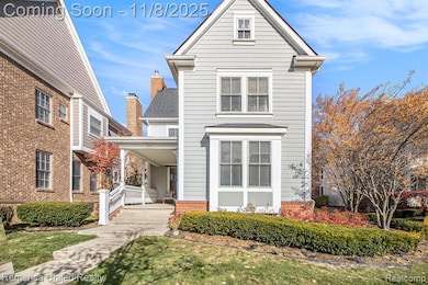
619 Mckinley Cir Canton, MI 48188
Cherry Hill NeighborhoodEstimated payment $3,386/month
Highlights
- Colonial Architecture
- Vaulted Ceiling
- Double Oven
- Canton High School Rated A
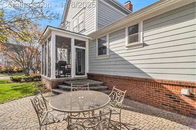
- Covered Patio or Porch
- 4-minute walk to The Big Park
About This Home
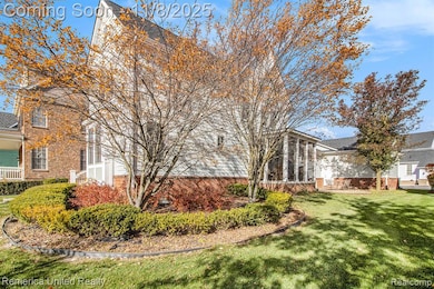
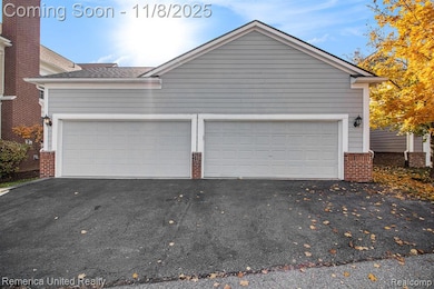
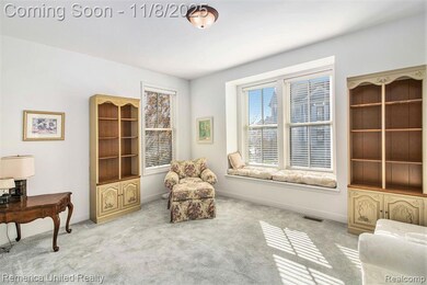
Welcome to this beautiful home in one of Canton’s most desirable neighborhoods, Cherry Hill Village! The inviting covered front porch and impressive 8-foot entry door set the tone for the style and space you’ll find inside. Step into the main level featuring 9' ceilings and 8' doors throughout. The large home office offers a stunning bay window with a custom built-in storage bench and French door entry. The living room is welcoming with a cozy gas fireplace framed by windows. The open layout connects seamlessly to the kitchen, which features newer granite countertops, tile backsplash, double oven, pantry, and newer black stainless steel refrigerator and dishwasher. A sliding door off the kitchen opens to a gorgeous three season room, fully screened, with a tiled floor, stained wood ceiling, and ceiling fan for comfort. From there, step out to the brick paver patio surrounded by beautiful landscaping, the perfect spot to relax or entertain. The first floor primary suite offers a vaulted ceiling, a large walk-in closet, soaking tub, dual sinks, and a cozy heat lamp. The main floor laundry includes a sink, window for natural light, and washer/dryer that stay with the home. A true standout feature is the FOUR car garage, rare for Cherry Hill Village. It has 11' 6" ceilings (perfect for a hoist), full attic access, 220 outlet, workbench, and storage shelves. Upstairs you’ll find three additional bedrooms, all with double closets, and a full bath with double sinks and tiled tub/shower. The full basement offers over 1,400 square feet ready to be finished. Additional highlights include a BRAND NEW ROOF (2025) and a larger than average lot for the neighborhood. Cherry Hill Village is known for its green spaces, charming parks, tree lined streets, friendly walking trails and sidewalks. Located near shopping, restaurants, and highways for easy commuting to Ann Arbor or Detroit. All remaining furniture is negotiable. Please come see this exceptional home for yourself!
Home Details
Home Type
- Single Family
Est. Annual Taxes
Year Built
- Built in 2002
Lot Details
- 6,534 Sq Ft Lot
- Lot Dimensions are 56x115
- Sprinkler System
HOA Fees
- $70 Monthly HOA Fees
Home Design
- Colonial Architecture
- Brick Exterior Construction
- Poured Concrete
- Asphalt Roof
- Vinyl Construction Material
Interior Spaces
- 2,217 Sq Ft Home
- 2-Story Property
- Furnished or left unfurnished upon request
- Vaulted Ceiling
- Gas Fireplace
- Family Room with Fireplace
- Unfinished Basement
- Sump Pump
Kitchen
- Double Oven
- Electric Cooktop
- Microwave
- Dishwasher
- Stainless Steel Appliances
- Disposal
Bedrooms and Bathrooms
- 4 Bedrooms
- Soaking Tub
Laundry
- Dryer
- Washer
Parking
- 4 Car Direct Access Garage
- Workshop in Garage
- Rear-Facing Garage
- Garage Door Opener
Outdoor Features
- Covered Patio or Porch
- Exterior Lighting
Location
- Ground Level
Utilities
- Forced Air Heating System
- Heating System Uses Natural Gas
- High Speed Internet
Listing and Financial Details
- Assessor Parcel Number 71073040154000
Community Details
Overview
- Herriman & Associates Chv 1 HOA, Phone Number (734) 459-5440
- Replat 10 Of Wayne County Condo Sub Plan 590 Cherry H Subdivision
Amenities
- Laundry Facilities
Map
Home Values in the Area
Average Home Value in this Area
Tax History
| Year | Tax Paid | Tax Assessment Tax Assessment Total Assessment is a certain percentage of the fair market value that is determined by local assessors to be the total taxable value of land and additions on the property. | Land | Improvement |
|---|---|---|---|---|
| 2025 | $3,130 | $256,700 | $0 | $0 |
| 2024 | $3,130 | $242,800 | $0 | $0 |
| 2023 | $2,984 | $211,300 | $0 | $0 |
| 2022 | $6,461 | $195,700 | $0 | $0 |
| 2021 | $6,270 | $194,500 | $0 | $0 |
| 2020 | $6,195 | $193,300 | $0 | $0 |
| 2019 | $6,081 | $170,150 | $0 | $0 |
| 2018 | $2,536 | $166,780 | $0 | $0 |
| 2017 | $6,136 | $162,400 | $0 | $0 |
| 2016 | $5,523 | $162,300 | $0 | $0 |
| 2015 | $13,935 | $146,810 | $0 | $0 |
| 2013 | $13,500 | $154,300 | $0 | $0 |
| 2010 | -- | $131,290 | $47,339 | $83,951 |
Property History
| Date | Event | Price | List to Sale | Price per Sq Ft |
|---|---|---|---|---|
| 11/08/2025 11/08/25 | For Sale | $515,000 | -- | $232 / Sq Ft |
Purchase History
| Date | Type | Sale Price | Title Company |
|---|---|---|---|
| Interfamily Deed Transfer | -- | None Available | |
| Deed | -- | -- |
Source: Realcomp
MLS Number: 20251052239
APN: 71-073-04-0154-000
Disclaimer: Certain information contained herein is derived from information provided by parties other than Homes.com. All information provided is deemed reliable, but is not guaranteed to be accurate and should be independently verified.
![]() IDX provided courtesy of Realcomp II Ltd. via Ten-X and MLS
IDX provided courtesy of Realcomp II Ltd. via Ten-X and MLS
Copyright 2025 Realcomp II Ltd. Shareholders
IDX information is provided exclusively for consumers' personal, noncommercial use and may not be used for any purpose other than to identify prospective properties consumers may be interested in purchasing. The accuracy of all information, regardless of source, is not guaranteed or warranted. All information should be independently verified.
Listing Information presented by local MLS brokerage: Ten-X, local REALTOR®- Arlene Richardson - (888)-952-6393
- 000 Filmore St
- 001 Filmore St
- 002 Filmore St
- 424 Roosevelt St Unit 233
- 897 Harrison St
- 798 Taylor Ln Unit 163
- 50249 Jefferson St Unit 415
- 49630 Taft Ln Unit 209
- 427 Patriot St Unit 173
- 49645 Hancock St
- 49592 Garfield Ln Unit 178
- 000 Patriot St
- 50595 Coolidge St
- 50594 Paine St
- 961 Truman Dr
- 1039 Truman Dr
- 50489 Eisenhower Dr
- 51014 Sleepy Hollow Ln Unit 1
- 0000 Denton Rd
- 00000 Denton Rd
- 50089 Monroe St Unit 90
- 897 Harrison St
- 534 Constitution St Unit 42
- 362 Filmore St Unit 141
- 362 Filmore St
- 315 Liberty St
- 49730 Uptown Ave
- 50903 Steed Dr
- 48514 Gladstone Rd
- 49685 Lantern Way
- 49300 Crabtree Crossing
- 47498 Fox Run Dr
- 48551 Oak Bridge Dr Unit 61
- 45866 Fountain View Dr
- 3839 Norwich Dr
- 1315 Waterside
- 47447-47653 Sleeping Bear Blvd
- 45373 Seabrook Dr
- 45762 S Stonewood Rd
- 46000 Geddes Rd Unit 156
