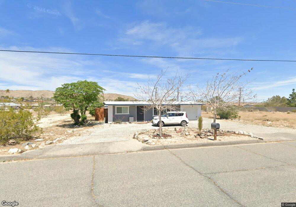
61930 Chollita Rd Joshua Tree, CA 92252
Estimated Value: $231,712 - $321,000
2
Beds
1
Bath
806
Sq Ft
$354/Sq Ft
Est. Value
About This Home
This home is located at 61930 Chollita Rd, Joshua Tree, CA 92252 and is currently estimated at $284,928, approximately $353 per square foot. 61930 Chollita Rd is a home located in San Bernardino County with nearby schools including Joshua Tree Elementary School, La Contenta Middle School, and Yucca Valley High School.
Ownership History
Date
Name
Owned For
Owner Type
Purchase Details
Closed on
Dec 12, 2011
Sold by
Blankenship Ronald
Bought by
Barksdale Heritage Trust
Current Estimated Value
Purchase Details
Closed on
May 13, 2010
Sold by
The Secretary Of Housing & Urban Develop
Bought by
Blankenship Ronald
Purchase Details
Closed on
Jan 15, 2010
Sold by
Wells Fargo Bank Na
Bought by
The Secretary Of Housing & Urban Develop
Purchase Details
Closed on
Dec 15, 2009
Sold by
Brown Douglas D
Bought by
Wells Fargo Bank Na
Purchase Details
Closed on
Jan 6, 2005
Sold by
Fancher Phyllis J
Bought by
Brown Douglas D
Home Financials for this Owner
Home Financials are based on the most recent Mortgage that was taken out on this home.
Original Mortgage
$88,211
Interest Rate
5.74%
Mortgage Type
FHA
Create a Home Valuation Report for This Property
The Home Valuation Report is an in-depth analysis detailing your home's value as well as a comparison with similar homes in the area
Home Values in the Area
Average Home Value in this Area
Purchase History
| Date | Buyer | Sale Price | Title Company |
|---|---|---|---|
| Barksdale Heritage Trust | -- | None Available | |
| Blankenship Ronald | $27,500 | Pacific Coast Title | |
| The Secretary Of Housing & Urban Develop | -- | First American Title Ins Co | |
| Wells Fargo Bank Na | $95,920 | Accommodation | |
| Brown Douglas D | $89,000 | Fidelity National Title Co |
Source: Public Records
Mortgage History
| Date | Status | Borrower | Loan Amount |
|---|---|---|---|
| Previous Owner | Brown Douglas D | $88,211 |
Source: Public Records
Tax History Compared to Growth
Tax History
| Year | Tax Paid | Tax Assessment Tax Assessment Total Assessment is a certain percentage of the fair market value that is determined by local assessors to be the total taxable value of land and additions on the property. | Land | Improvement |
|---|---|---|---|---|
| 2025 | $869 | $47,730 | $10,049 | $37,681 |
| 2024 | $869 | $46,794 | $9,852 | $36,942 |
| 2023 | $854 | $45,877 | $9,659 | $36,218 |
| 2022 | $838 | $44,978 | $9,470 | $35,508 |
| 2021 | $828 | $44,096 | $9,284 | $34,812 |
| 2020 | $820 | $43,644 | $9,189 | $34,455 |
| 2019 | $850 | $42,788 | $9,009 | $33,779 |
| 2018 | $686 | $41,949 | $8,832 | $33,117 |
| 2017 | $681 | $41,127 | $8,659 | $32,468 |
| 2016 | $671 | $40,320 | $8,489 | $31,831 |
| 2015 | $640 | $39,714 | $8,361 | $31,353 |
| 2014 | $664 | $38,936 | $8,197 | $30,739 |
Source: Public Records
Map
Nearby Homes
- 6426 Valley View St Unit 9
- 6360 El Reposo St
- 61850 Chollita Rd
- 61984 Commercial St
- 6394 Mountain View St
- 6426 Park Blvd
- 6186 El Reposo St
- 1234 29 Palms Hwy
- Hwy California 62
- 66262 29 Palms Hwy
- 66500 29 Palms Hwy
- 60750 29 Palms Hwy
- 1 29 Palms Hwy
- 61956 Aster Place
- 6451 Mountain View St
- 61959 Begonia Place
- 6124 El Reposo St
- 61720 Commercial St
- 0 Valley View St Unit CV23078864
- 0 Begonia Place Unit IV25254140
- 6315 El Reposo St
- 61933 Verbena Rd
- 61960 Chollita Rd
- 61941 Verbena Rd
- 6320 El Reposo St Unit C
- 6320 El Reposo St
- 61959 Verbena Rd
- 61970 Chollita Rd
- 6426 Valley View St Unit 35
- 6426 Valley View St Unit 20
- 6426 Valley View St Unit 37
- 6426 Valley View St Unit 63
- 6426 Valley View St Unit 52
- 6426 Valley View St Unit 61
- 6426 Valley View St Unit 58
- 6426 Valley View St Unit 31
- 6426 Valley View St
- 6426 Valley View St Unit 41
- 6426 Valley View St Unit 62
- 6426 Valley View St Unit 49