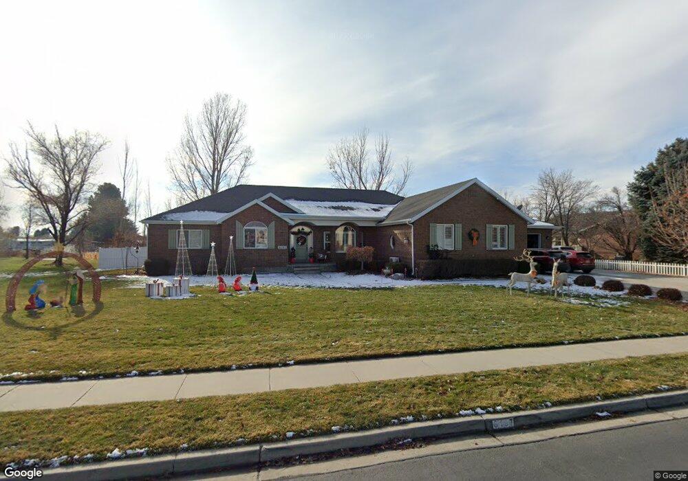
6197 W 10150 N Highland, UT 84003
Estimated Value: $1,123,000 - $1,238,476
3
Beds
3
Baths
4,596
Sq Ft
$254/Sq Ft
Est. Value
About This Home
This home is located at 6197 W 10150 N, Highland, UT 84003 and is currently estimated at $1,169,619, approximately $254 per square foot. 6197 W 10150 N is a home located in Utah County with nearby schools including Freedom Elementary School, Mountain Ridge Junior High School, and American Fork High School.
Ownership History
Date
Name
Owned For
Owner Type
Purchase Details
Closed on
Oct 26, 2019
Sold by
Knighton Douglas and Knighton Katie
Bought by
Knighton Katie
Current Estimated Value
Home Financials for this Owner
Home Financials are based on the most recent Mortgage that was taken out on this home.
Original Mortgage
$484,350
Outstanding Balance
$426,948
Interest Rate
3.7%
Mortgage Type
New Conventional
Estimated Equity
$742,671
Purchase Details
Closed on
Jun 29, 2016
Sold by
Mclelland Dennis L
Bought by
Knighton Douglas and Knighton Katie
Home Financials for this Owner
Home Financials are based on the most recent Mortgage that was taken out on this home.
Original Mortgage
$417,000
Interest Rate
3.66%
Mortgage Type
New Conventional
Purchase Details
Closed on
Apr 18, 2016
Sold by
Sixmax Holdings Llc
Bought by
Mclelland Dennis L
Purchase Details
Closed on
Jan 18, 2014
Sold by
Mclelland Dennis L
Bought by
Mclelland Dennis L and Mclelland Shawn
Home Financials for this Owner
Home Financials are based on the most recent Mortgage that was taken out on this home.
Original Mortgage
$252,562
Interest Rate
4.4%
Mortgage Type
New Conventional
Purchase Details
Closed on
Oct 15, 2012
Sold by
Mclelland Dennis L and Mclelland Sheila
Bought by
Mclelland Dennis J
Home Financials for this Owner
Home Financials are based on the most recent Mortgage that was taken out on this home.
Original Mortgage
$655,500
Interest Rate
3.5%
Mortgage Type
Reverse Mortgage Home Equity Conversion Mortgage
Purchase Details
Closed on
Apr 4, 2008
Sold by
Mclelland Dennis L and Mclelland Shelia
Bought by
Mclelland Dennis L and Mclelland Sheila
Purchase Details
Closed on
Jan 30, 2001
Sold by
Brooksby Ryan V and Brooksby Andrea T
Bought by
Mclelland Dennis and Mclelland Shelia
Purchase Details
Closed on
Jun 26, 1997
Sold by
T & R Corp
Bought by
Brooksby Ryan V and Brooksby Andrea T
Home Financials for this Owner
Home Financials are based on the most recent Mortgage that was taken out on this home.
Original Mortgage
$150,000
Interest Rate
7.91%
Mortgage Type
Construction
Create a Home Valuation Report for This Property
The Home Valuation Report is an in-depth analysis detailing your home's value as well as a comparison with similar homes in the area
Home Values in the Area
Average Home Value in this Area
Purchase History
| Date | Buyer | Sale Price | Title Company |
|---|---|---|---|
| Knighton Katie | -- | Lydolph & Weierholt Ttl Ins | |
| Knighton Douglas | -- | Cottonwood Title Ins Ag | |
| Mclelland Dennis L | -- | Accommodation | |
| Mclelland Dennis L | -- | North American Title | |
| Mclelland Dennis J | -- | None Available | |
| Mclelland Dennis L | -- | Provo Land Title Company | |
| Mclelland Dennis | -- | Associated Title Company | |
| Brooksby Ryan V | -- | First American Title |
Source: Public Records
Mortgage History
| Date | Status | Borrower | Loan Amount |
|---|---|---|---|
| Open | Knighton Katie | $484,350 | |
| Closed | Knighton Douglas | $417,000 | |
| Previous Owner | Mclelland Dennis L | $252,562 | |
| Previous Owner | Mclelland Dennis J | $655,500 | |
| Previous Owner | Brooksby Ryan V | $150,000 | |
| Closed | Brooksby Ryan V | $25,450 |
Source: Public Records
Tax History Compared to Growth
Tax History
| Year | Tax Paid | Tax Assessment Tax Assessment Total Assessment is a certain percentage of the fair market value that is determined by local assessors to be the total taxable value of land and additions on the property. | Land | Improvement |
|---|---|---|---|---|
| 2025 | $4,226 | $595,815 | $430,900 | $652,400 |
| 2024 | $4,226 | $522,005 | $0 | $0 |
| 2023 | $3,871 | $515,845 | $0 | $0 |
| 2022 | $3,745 | $483,890 | $0 | $0 |
| 2021 | $3,454 | $664,600 | $260,700 | $403,900 |
| 2020 | $3,279 | $618,800 | $226,700 | $392,100 |
| 2019 | $2,746 | $542,100 | $226,700 | $315,400 |
| 2018 | $2,591 | $486,100 | $207,000 | $279,100 |
| 2017 | $2,199 | $220,220 | $0 | $0 |
| 2016 | $2,452 | $229,515 | $0 | $0 |
| 2015 | $2,526 | $224,070 | $0 | $0 |
| 2014 | $2,333 | $205,095 | $0 | $0 |
Source: Public Records
Map
Nearby Homes
- 6190 W 10050 N
- 6399 W 10150 N
- 11337 N 5950 W Unit 7
- 5973 W 9960 N
- 6372 W 10400 N
- 9780 N 6000 W
- 10434 N 6400 W
- 6373 W 10500 N
- 10197 N 5750 W
- 9924 N 6630 W Unit 9
- 9947 N Yorkshire Ct
- 9967 N 6670 W
- 703 S 850 W
- 1438 N 400 W
- 5586 W 10130 N
- 6692 W 9770 N
- 287 W 1360 N
- 356 W 1300 N
- 35 W 1350 N
- 6271 W 10830 St N