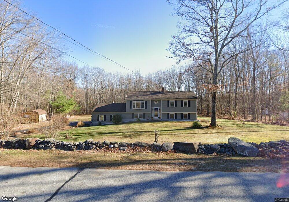
62 Oak Ridge Dr Standish, ME 04084
Estimated Value: $417,500 - $528,000
3
Beds
2
Baths
2,150
Sq Ft
$221/Sq Ft
Est. Value
About This Home
This home is located at 62 Oak Ridge Dr, Standish, ME 04084 and is currently estimated at $476,125, approximately $221 per square foot. 62 Oak Ridge Dr is a home located in Cumberland County with nearby schools including Bonny Eagle High School and Standish Baptist Academy.
Ownership History
Date
Name
Owned For
Owner Type
Purchase Details
Closed on
Nov 14, 2006
Sold by
Tibbetts Lawrence J and Tibbetts Joan K
Bought by
Clifford Edwin and Clifford Debora
Current Estimated Value
Home Financials for this Owner
Home Financials are based on the most recent Mortgage that was taken out on this home.
Original Mortgage
$204,600
Outstanding Balance
$121,701
Interest Rate
6.31%
Mortgage Type
Purchase Money Mortgage
Estimated Equity
$354,424
Create a Home Valuation Report for This Property
The Home Valuation Report is an in-depth analysis detailing your home's value as well as a comparison with similar homes in the area
Home Values in the Area
Average Home Value in this Area
Purchase History
| Date | Buyer | Sale Price | Title Company |
|---|---|---|---|
| Clifford Edwin | -- | -- |
Source: Public Records
Mortgage History
| Date | Status | Borrower | Loan Amount |
|---|---|---|---|
| Open | Clifford Edwin | $204,600 |
Source: Public Records
Tax History Compared to Growth
Tax History
| Year | Tax Paid | Tax Assessment Tax Assessment Total Assessment is a certain percentage of the fair market value that is determined by local assessors to be the total taxable value of land and additions on the property. | Land | Improvement |
|---|---|---|---|---|
| 2024 | $4,404 | $349,500 | $77,700 | $271,800 |
| 2023 | $4,058 | $293,000 | $65,100 | $227,900 |
| 2022 | $4,023 | $278,400 | $58,100 | $220,300 |
| 2021 | $3,488 | $257,500 | $52,900 | $204,600 |
| 2019 | $3,425 | $239,500 | $50,300 | $189,200 |
| 2018 | $3,257 | $234,300 | $45,100 | $189,200 |
| 2017 | $3,104 | $234,300 | $45,100 | $189,200 |
| 2016 | $3,004 | $234,300 | $45,100 | $189,200 |
| 2015 | $2,997 | $234,300 | $45,100 | $189,200 |
| 2013 | -- | $234,300 | $45,100 | $189,200 |
Source: Public Records
Map
Nearby Homes
- 27 Ossipee Trail E Unit 1
- 1 Macie Dr Unit 84
- 66 Ossipee Trail East Trail E
- 11 Macie Dr Unit 79
- 7 Macie Dr
- 63 Ossipee Trail E
- 4 Cortland Place Unit 3
- 6 Cortland Place Unit 4
- 8 Cortland Place Unit 5
- 33 Woodbrey Ln
- 31 Woodbrey Ln
- 41 Shaws Mill Rd
- 170&0 Cram Rd
- 103 Kayli Dr
- 9 Macie Dr
- 49 Woodbrey Ln
- 28 Woodbrey Ln
- 47 Woodbrey Ln
- 221 Job Rd
- LOT #8 Eastern Ln
- 64 Oak Ridge Dr
- 61 Oak Ridge Dr
- 19 Oak Ridge Dr
- 57 Oak Ridge Dr
- 56 Oak Ridge Dr
- 66 Oak Ridge Dr
- 55 Oak Ridge Dr
- 21 Oak Ridge Dr
- 54 Oak Ridge Dr
- 23 Oak Ridge Dr
- 17 Oak Ridge Dr
- 51 Oak Ridge Dr
- 18 Oak Ridge Dr
- 52 Oak Ridge Dr
- 22 Oak Ridge Dr
- 25 Oak Ridge Dr
- 16 Oak Ridge Dr
- 27 Oak Ridge Dr
- 24 Oak Ridge Dr
- 14 Oak Ridge Dr