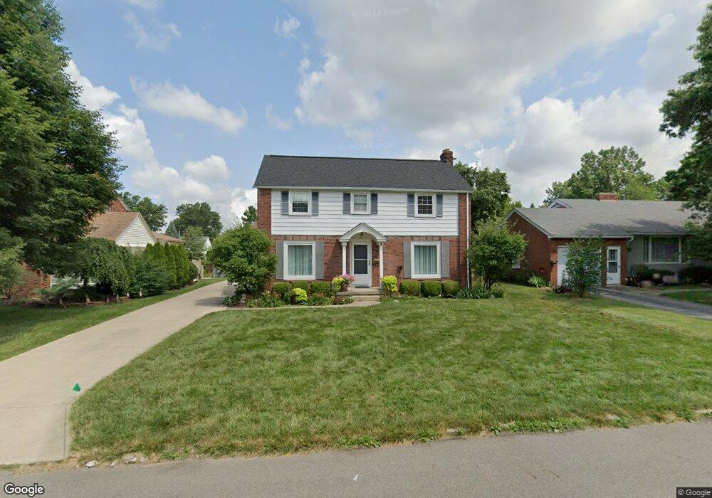
620 Barnard Ave Mansfield, OH 44903
Estimated Value: $165,000 - $169,000
3
Beds
2
Baths
1,360
Sq Ft
$122/Sq Ft
Est. Value
About This Home
This home is located at 620 Barnard Ave, Mansfield, OH 44903 and is currently estimated at $166,273, approximately $122 per square foot. 620 Barnard Ave is a home located in Richland County with nearby schools including Discovery School, St. Peter's High School/Junior High, and St. Peter's Elementary/Montessori School.
Ownership History
Date
Name
Owned For
Owner Type
Purchase Details
Closed on
Aug 27, 1999
Sold by
Pifer Wilma N
Bought by
Conard Ronald N and Conard Lori K
Current Estimated Value
Home Financials for this Owner
Home Financials are based on the most recent Mortgage that was taken out on this home.
Original Mortgage
$75,600
Outstanding Balance
$22,051
Interest Rate
7.61%
Mortgage Type
New Conventional
Estimated Equity
$144,222
Create a Home Valuation Report for This Property
The Home Valuation Report is an in-depth analysis detailing your home's value as well as a comparison with similar homes in the area
Home Values in the Area
Average Home Value in this Area
Purchase History
| Date | Buyer | Sale Price | Title Company |
|---|---|---|---|
| Conard Ronald N | $94,500 | -- |
Source: Public Records
Mortgage History
| Date | Status | Borrower | Loan Amount |
|---|---|---|---|
| Open | Conard Ronald N | $75,600 |
Source: Public Records
Tax History Compared to Growth
Tax History
| Year | Tax Paid | Tax Assessment Tax Assessment Total Assessment is a certain percentage of the fair market value that is determined by local assessors to be the total taxable value of land and additions on the property. | Land | Improvement |
|---|---|---|---|---|
| 2024 | $1,915 | $40,880 | $4,540 | $36,340 |
| 2023 | $1,915 | $40,880 | $4,540 | $36,340 |
| 2022 | $1,657 | $29,640 | $3,900 | $25,740 |
| 2021 | $1,669 | $29,640 | $3,900 | $25,740 |
| 2020 | $1,707 | $29,640 | $3,900 | $25,740 |
| 2019 | $1,891 | $29,640 | $3,900 | $25,740 |
| 2018 | $1,866 | $29,640 | $3,900 | $25,740 |
| 2017 | $1,815 | $29,640 | $3,900 | $25,740 |
| 2016 | $1,685 | $26,680 | $5,000 | $21,680 |
| 2015 | $1,610 | $26,680 | $5,000 | $21,680 |
| 2014 | $1,589 | $26,680 | $5,000 | $21,680 |
| 2012 | $605 | $26,680 | $5,260 | $21,420 |
Source: Public Records
Map
Nearby Homes
- 679 Coleman Rd
- 616 Cline Ave
- 538 Broadview Ave
- 408 Fairlawn Ave
- 191 Fairlawn Ave
- 133 Stewart Ave S
- 118 Parkwood Blvd
- 212 Marlow Rd
- 126 Dawson Ave
- 143 Fairlawn Ave
- 135 Fairlawn Ave
- 129 Fairlawn Ave
- 78 Glenwood Blvd
- 71 Glenwood Blvd
- 88 Sherman Ave
- 41 Parkwood Blvd
- 190 S Linden Rd
- 76 Bartley Ave
- 24 Stewart Ave S
- 21 Glenwood Blvd
- 612 Barnard Ave
- 624 Barnard Ave
- 628 Barnard Ave
- 621 Coleman Rd
- 606 Barnard Ave
- 613 Coleman Rd
- 633 Coleman Rd
- 638 Barnard Ave
- 619 Barnard Ave
- 598 Barnard Ave
- 611 Barnard Ave
- 625 Barnard Ave
- 603 Coleman Rd
- 0 Barnard Ave
- 607 Barnard Ave
- 631 Barnard Ave
- 643 Coleman Rd
- 597 Barnard Ave
- 592 Barnard Ave
- 637 Barnard Ave