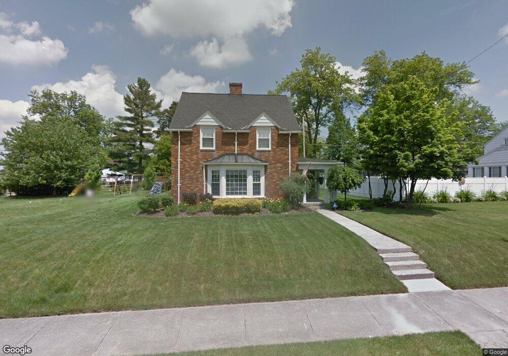
620 Coleman Rd Mansfield, OH 44903
Estimated Value: $195,465 - $219,000
3
Beds
2
Baths
2,063
Sq Ft
$100/Sq Ft
Est. Value
About This Home
This home is located at 620 Coleman Rd, Mansfield, OH 44903 and is currently estimated at $206,616, approximately $100 per square foot. 620 Coleman Rd is a home located in Richland County with nearby schools including Goal Digital Academy, Discovery School, and St. Peter's High School/Junior High.
Ownership History
Date
Name
Owned For
Owner Type
Purchase Details
Closed on
May 7, 2001
Sold by
O'Brien Jean E
Bought by
Weaver Troy J and Hicks Jennifer A
Current Estimated Value
Home Financials for this Owner
Home Financials are based on the most recent Mortgage that was taken out on this home.
Original Mortgage
$86,850
Interest Rate
6.95%
Mortgage Type
New Conventional
Create a Home Valuation Report for This Property
The Home Valuation Report is an in-depth analysis detailing your home's value as well as a comparison with similar homes in the area
Home Values in the Area
Average Home Value in this Area
Purchase History
| Date | Buyer | Sale Price | Title Company |
|---|---|---|---|
| Weaver Troy J | $96,500 | -- |
Source: Public Records
Mortgage History
| Date | Status | Borrower | Loan Amount |
|---|---|---|---|
| Closed | Weaver Troy J | $86,850 |
Source: Public Records
Tax History Compared to Growth
Tax History
| Year | Tax Paid | Tax Assessment Tax Assessment Total Assessment is a certain percentage of the fair market value that is determined by local assessors to be the total taxable value of land and additions on the property. | Land | Improvement |
|---|---|---|---|---|
| 2024 | $2,245 | $47,940 | $3,350 | $44,590 |
| 2023 | $2,245 | $47,940 | $3,350 | $44,590 |
| 2022 | $1,761 | $31,520 | $2,870 | $28,650 |
| 2021 | $1,773 | $31,520 | $2,870 | $28,650 |
| 2020 | $1,813 | $31,520 | $2,870 | $28,650 |
| 2019 | $2,010 | $31,520 | $2,870 | $28,650 |
| 2018 | $1,982 | $31,520 | $2,870 | $28,650 |
| 2017 | $1,955 | $31,520 | $2,870 | $28,650 |
| 2016 | $1,980 | $31,380 | $3,960 | $27,420 |
| 2015 | $1,892 | $31,380 | $3,960 | $27,420 |
| 2014 | $994 | $31,380 | $3,960 | $27,420 |
| 2012 | $1,497 | $33,020 | $4,160 | $28,860 |
Source: Public Records
Map
Nearby Homes
- 679 Coleman Rd
- 616 Cline Ave
- 538 Broadview Ave
- 133 Stewart Ave S
- 191 Fairlawn Ave
- 118 Parkwood Blvd
- 126 Dawson Ave
- 408 Fairlawn Ave
- 143 Fairlawn Ave
- 212 Marlow Rd
- 135 Fairlawn Ave
- 129 Fairlawn Ave
- 78 Glenwood Blvd
- 88 Sherman Ave
- 41 Parkwood Blvd
- 76 Bartley Ave
- 24 Stewart Ave S
- 21 Glenwood Blvd
- 190 S Linden Rd
- 114 Vennum Ave
- 632 Coleman Rd
- 612 Coleman Rd
- 638 Coleman Rd
- 642 Coleman Rd
- 621 Coleman Rd
- 633 Coleman Rd
- 631 Arlington Ave
- 637 Arlington Ave
- 606 Coleman Rd
- 619 Arlington Ave
- 641 Arlington Ave
- 613 Coleman Rd
- 643 Coleman Rd
- 648 Coleman Rd
- 617 Arlington Ave
- 620 Barnard Ave
- 628 Barnard Ave
- 603 Coleman Rd
- 645 Arlington Ave
- 611 Arlington Ave