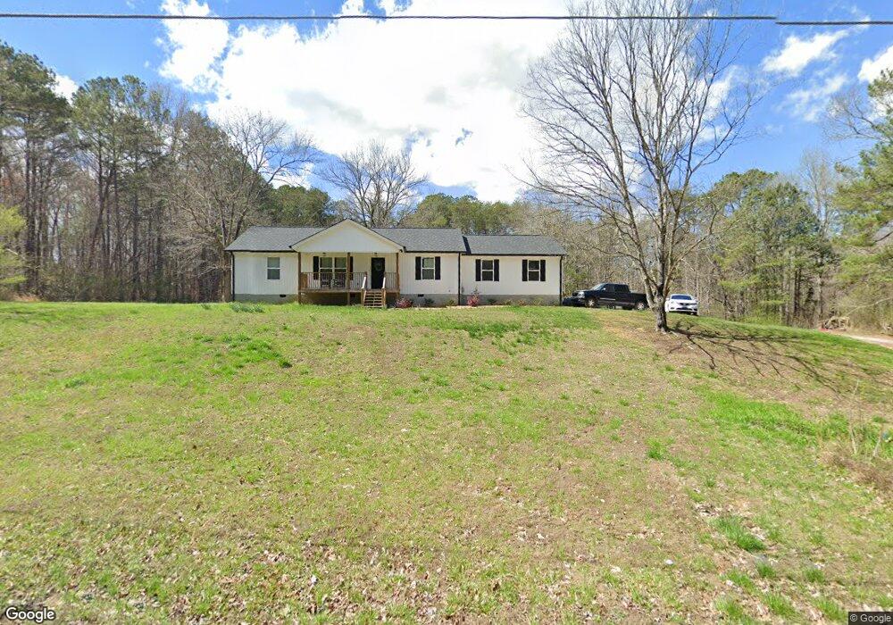
620 Hankins Rd Rock Spring, GA 30739
Rock Spring NeighborhoodEstimated Value: $315,144 - $404,000
--
Bed
1
Bath
1,338
Sq Ft
$264/Sq Ft
Est. Value
About This Home
This home is located at 620 Hankins Rd, Rock Spring, GA 30739 and is currently estimated at $353,536, approximately $264 per square foot. 620 Hankins Rd is a home located in Walker County with nearby schools including Rock Spring Elementary School, Lafayette High School, and Alice M Daley Adventist School.
Ownership History
Date
Name
Owned For
Owner Type
Purchase Details
Closed on
Aug 24, 2020
Sold by
Hurd Enoch
Bought by
Cass Brandon Michael
Current Estimated Value
Purchase Details
Closed on
Sep 11, 2018
Sold by
Dausey Cardin Steve
Bought by
Hurd Enoch Trustee and Hurd Rev Liv Trust
Purchase Details
Closed on
Dec 5, 2017
Sold by
Peters Darren Lee
Bought by
Dausey Cardin Steve
Purchase Details
Closed on
Jan 30, 2009
Sold by
Williams Carolyn L
Bought by
Peters Darren Lee
Purchase Details
Closed on
Jan 1, 1972
Bought by
Lumpkin Margaret M Life Est
Create a Home Valuation Report for This Property
The Home Valuation Report is an in-depth analysis detailing your home's value as well as a comparison with similar homes in the area
Home Values in the Area
Average Home Value in this Area
Purchase History
| Date | Buyer | Sale Price | Title Company |
|---|---|---|---|
| Cass Brandon Michael | $8,000 | -- | |
| Hurd Enoch Trustee | $11,000 | -- | |
| Dausey Cardin Steve | $10,000 | -- | |
| Peters Darren Lee | -- | -- | |
| Lumpkin Margaret M Life Est | -- | -- |
Source: Public Records
Tax History Compared to Growth
Tax History
| Year | Tax Paid | Tax Assessment Tax Assessment Total Assessment is a certain percentage of the fair market value that is determined by local assessors to be the total taxable value of land and additions on the property. | Land | Improvement |
|---|---|---|---|---|
| 2024 | $2,584 | $118,037 | $11,869 | $106,168 |
| 2023 | $2,470 | $110,202 | $9,420 | $100,782 |
| 2022 | $1,843 | $73,557 | $8,187 | $65,370 |
| 2021 | $211 | $8,187 | $8,187 | $0 |
| 2020 | $756 | $23,023 | $8,187 | $14,836 |
| 2019 | $260 | $23,023 | $8,187 | $14,836 |
| 2018 | $609 | $23,023 | $8,187 | $14,836 |
| 2017 | $777 | $23,023 | $8,187 | $14,836 |
| 2016 | $644 | $23,023 | $8,187 | $14,836 |
| 2015 | $769 | $26,524 | $11,068 | $15,456 |
| 2014 | $684 | $26,524 | $11,068 | $15,456 |
| 2013 | -- | $26,524 | $11,068 | $15,456 |
Source: Public Records
Map
Nearby Homes
- 0 Tarvin Rd Unit 1523862
- 5602 Georgia 95
- 00 Georgia 95
- 10180 Us Highway 27
- 0 Cheshire Crossing Dr Unit 1387793
- 0 Veeler Rd Unit 1522679
- 0 Veeler Rd Unit 10628696
- 1003 Highway N Old 27
- 15 Willow Cir
- 23 Willow Cir
- 16 Willow Cir
- 1370 Old Highway 27
- 11 Willow Cir
- The Pearson Plan at Laurel Ridge
- The Benson II Plan at Laurel Ridge
- The Langford Plan at Laurel Ridge
- The Lawson Plan at Laurel Ridge
- The Piedmont Plan at Laurel Ridge
- 692 Hankins Rd
- 15 Pappy Ln
- 526 Hankins Rd
- 504 Hankins Rd
- 0 Hankins Rd Unit 18224
- 0 Hankins Rd
- 95 Highway
- 511 Hankins Rd
- 778 Hankins Rd
- 737 Hankins Rd
- 502 Hankins Rd
- 819 Hankins Rd
- 433 Hankins Rd
- 386 Hankins Rd
- 851 Hankins Rd
- 389 Hankins Rd
- 290 Hankins Rd
- 945 Hankins Rd
- 2416 Highway 95
- 1677 Center Grove Rd