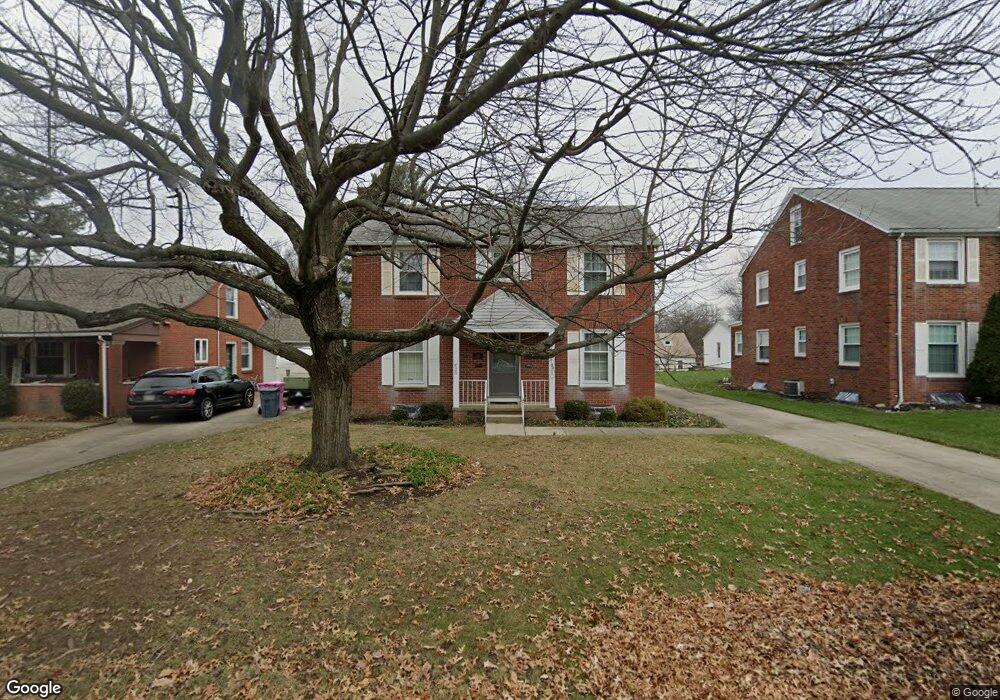
620 Manchester Rd Mansfield, OH 44903
Estimated Value: $167,000 - $183,557
4
Beds
2
Baths
2,176
Sq Ft
$80/Sq Ft
Est. Value
About This Home
This home is located at 620 Manchester Rd, Mansfield, OH 44903 and is currently estimated at $173,639, approximately $79 per square foot. 620 Manchester Rd is a home located in Richland County with nearby schools including Goal Digital Academy, Discovery School, and St. Peter's Elementary/Montessori School.
Ownership History
Date
Name
Owned For
Owner Type
Purchase Details
Closed on
Aug 2, 2021
Sold by
Wallace Sylvia R and The Estate Of Paula Roth
Bought by
Wells Shawn A
Current Estimated Value
Home Financials for this Owner
Home Financials are based on the most recent Mortgage that was taken out on this home.
Original Mortgage
$97,750
Outstanding Balance
$88,925
Interest Rate
2.93%
Mortgage Type
New Conventional
Estimated Equity
$84,714
Create a Home Valuation Report for This Property
The Home Valuation Report is an in-depth analysis detailing your home's value as well as a comparison with similar homes in the area
Home Values in the Area
Average Home Value in this Area
Purchase History
| Date | Buyer | Sale Price | Title Company |
|---|---|---|---|
| Wells Shawn A | $115,000 | Chicago Title |
Source: Public Records
Mortgage History
| Date | Status | Borrower | Loan Amount |
|---|---|---|---|
| Open | Wells Shawn A | $97,750 |
Source: Public Records
Tax History
| Year | Tax Paid | Tax Assessment Tax Assessment Total Assessment is a certain percentage of the fair market value that is determined by local assessors to be the total taxable value of land and additions on the property. | Land | Improvement |
|---|---|---|---|---|
| 2024 | $1,769 | $38,650 | $4,450 | $34,200 |
| 2023 | $1,810 | $38,650 | $4,450 | $34,200 |
| 2022 | $1,897 | $33,950 | $3,820 | $30,130 |
| 2021 | $1,418 | $33,950 | $3,820 | $30,130 |
| 2020 | $1,450 | $33,950 | $3,820 | $30,130 |
| 2019 | $1,607 | $33,950 | $3,820 | $30,130 |
| 2018 | $1,585 | $33,950 | $3,820 | $30,130 |
| 2017 | $1,542 | $33,950 | $3,820 | $30,130 |
| 2016 | $1,617 | $34,380 | $4,890 | $29,490 |
| 2015 | $1,617 | $34,380 | $4,890 | $29,490 |
| 2014 | $1,525 | $34,380 | $4,890 | $29,490 |
| 2012 | $1,404 | $34,390 | $5,150 | $29,240 |
Source: Public Records
Map
Nearby Homes
- 616 Cline Ave
- 679 Coleman Rd
- 455 Marion Ave
- 189 Westwood Ave
- 487 Davey Ave
- 133 Stewart Ave S
- 116 Stewart Ave S
- 143 Fairlawn Ave
- 282 Vennum Ave
- 356 S Linden Rd
- 108 Stewart Ave S
- 135 Fairlawn Ave
- 129 Fairlawn Ave
- 158 Vennum Ave
- 655 Woodhill Rd
- 960 W Linden Cir
- 341 Townview Cir N
- 24 Stewart Ave S
- 310 Townview Cir N
- 31 Bartley Ave
- 614 Manchester Rd
- 626 Manchester Rd
- 632 Manchester Rd
- 608 Manchester Rd
- 625 Barnard Ave
- 619 Barnard Ave
- 631 Barnard Ave
- 638 Manchester Rd
- 611 Barnard Ave
- 611 Manchester Rd
- 637 Barnard Ave
- 600 Manchester Rd
- 621 Manchester Rd
- 607 Barnard Ave
- 644 Manchester Rd
- 643 Barnard Ave
- 594 Manchester Rd
- 641 Manchester Rd
- 0 Barnard Ave
- 624 Barnard Ave
Your Personal Tour Guide
Ask me questions while you tour the home.