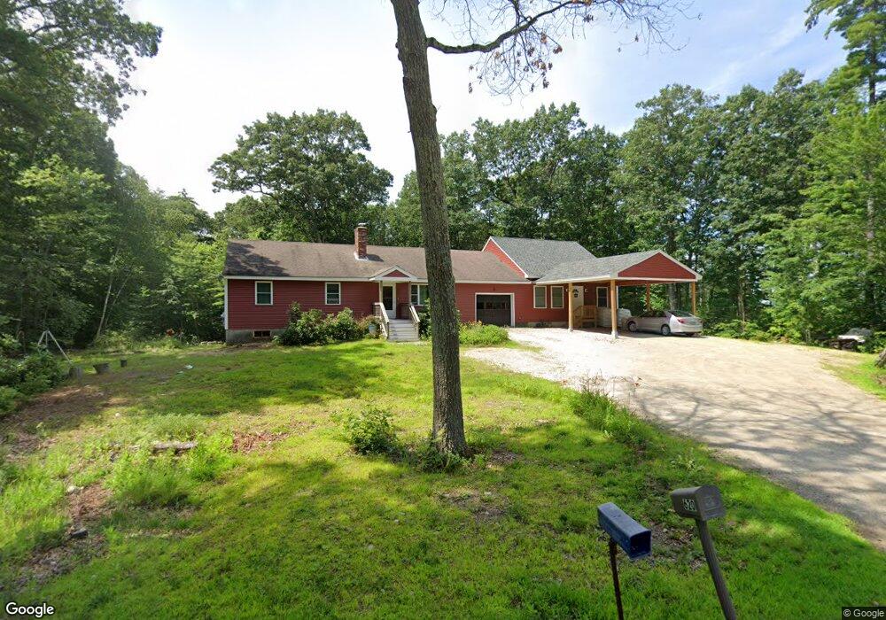
620 Pingree Hill Rd Auburn, NH 03032
Estimated Value: $568,000 - $838,000
4
Beds
3
Baths
2,977
Sq Ft
$232/Sq Ft
Est. Value
About This Home
This home is located at 620 Pingree Hill Rd, Auburn, NH 03032 and is currently estimated at $689,884, approximately $231 per square foot. 620 Pingree Hill Rd is a home located in Rockingham County with nearby schools including Auburn Village School, Pinkerton Academy, and The Goddard School - Derry.
Ownership History
Date
Name
Owned For
Owner Type
Purchase Details
Closed on
Jul 28, 2021
Sold by
Long Eldon A and Long Susan R
Bought by
Long Jason A and Long Shannon E
Current Estimated Value
Home Financials for this Owner
Home Financials are based on the most recent Mortgage that was taken out on this home.
Original Mortgage
$242,728
Outstanding Balance
$220,814
Interest Rate
2.93%
Mortgage Type
New Conventional
Estimated Equity
$469,070
Create a Home Valuation Report for This Property
The Home Valuation Report is an in-depth analysis detailing your home's value as well as a comparison with similar homes in the area
Home Values in the Area
Average Home Value in this Area
Purchase History
| Date | Buyer | Sale Price | Title Company |
|---|---|---|---|
| Long Jason A | $78,533 | None Available |
Source: Public Records
Mortgage History
| Date | Status | Borrower | Loan Amount |
|---|---|---|---|
| Open | Long Jason A | $242,728 |
Source: Public Records
Tax History Compared to Growth
Tax History
| Year | Tax Paid | Tax Assessment Tax Assessment Total Assessment is a certain percentage of the fair market value that is determined by local assessors to be the total taxable value of land and additions on the property. | Land | Improvement |
|---|---|---|---|---|
| 2024 | $7,318 | $543,300 | $189,100 | $354,200 |
| 2023 | $6,851 | $543,300 | $189,100 | $354,200 |
| 2022 | $5,566 | $311,800 | $127,200 | $184,600 |
| 2021 | $4,577 | $252,300 | $127,200 | $125,100 |
| 2020 | $8,285 | $252,300 | $127,200 | $125,100 |
| 2019 | $4,746 | $252,300 | $127,200 | $125,100 |
| 2018 | $4,304 | $252,300 | $127,200 | $125,100 |
| 2017 | $4,554 | $215,300 | $126,400 | $88,900 |
| 2016 | $4,360 | $215,300 | $126,400 | $88,900 |
| 2015 | $4,459 | $215,300 | $126,400 | $88,900 |
| 2014 | $4,588 | $215,300 | $126,400 | $88,900 |
| 2013 | $4,218 | $215,300 | $126,400 | $88,900 |
Source: Public Records
Map
Nearby Homes
- 8 Ledgewood Dr
- 4 Ledgewood Dr
- 70 English Range Rd
- 4 Viza Ave
- 80.5 English Range Rd
- 8 Mark Ave
- 54 Daniel Rd
- 50 Daniel Rd
- 52 Daniel Rd
- 6 Hilda Ave
- 7 Gena Ave
- 9 Dattillo Rd
- 78 Stonebridge Dr
- 27 Cove Dr
- 59 Hawthorne Dr
- 167 Chester Rd
- 34 Conifer Place
- 40 Pinyon Place
- 55 Norwich Place
- 30 Gypsum Ln Unit 29
- 628 Pingree Hill Rd
- 608 Pingree Hill Rd
- 625 Pingree Hill Rd
- 640 Pingree Hill Rd
- 641 Pingree Hill Rd
- 601 Pingree Hill Rd
- 24 Boxwood Dr
- 0 Boxwood Dr
- 596 Pingree Hill Rd
- 650 Pingree Hill Rd
- 645 Pingree Hill Rd
- 587 Pingree Hill Rd
- 588 Pingree Hill Rd
- 33 Boxwood Dr
- 659 Pingree Hill Rd
- Lot 2-44-7 Boxwood Dr
- 36 Boxwood Dr
- 662 Pingree Hill Rd
- 577 Pingree Hill Rd
- 35 Boxwood Dr