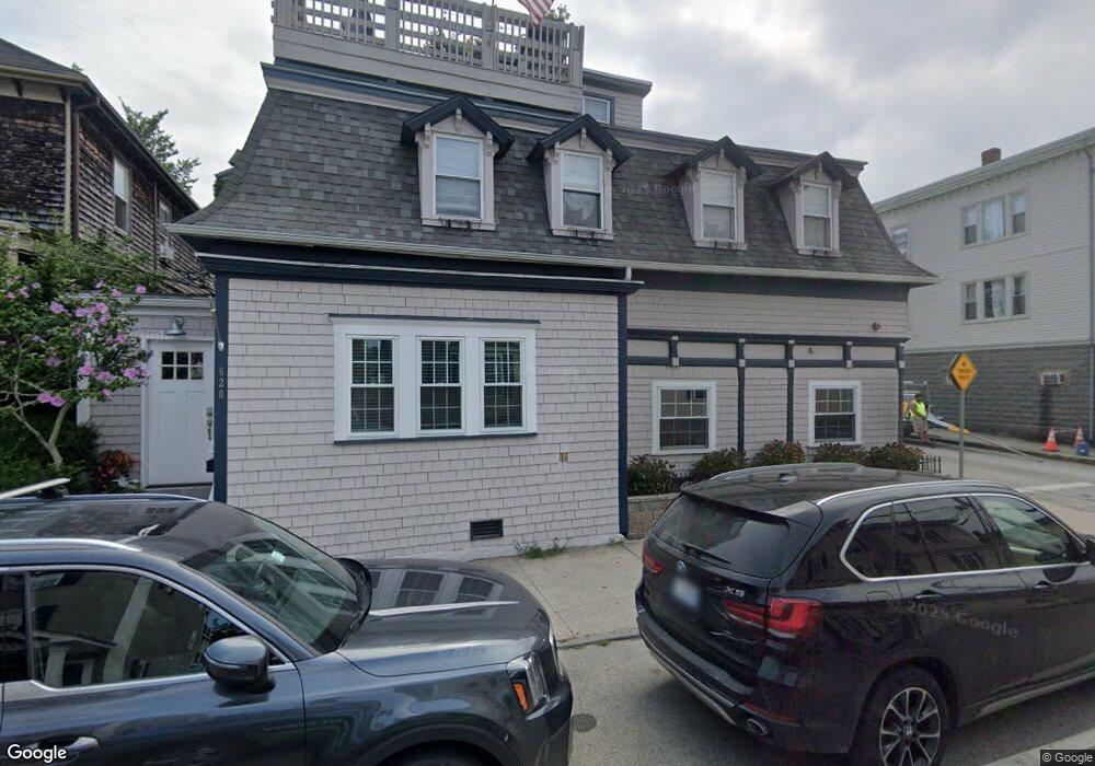
620 Thames St Unit 1 Newport, RI 02840
Fifth Ward NeighborhoodEstimated Value: $582,647 - $1,300,000
3
Beds
2
Baths
1,057
Sq Ft
$890/Sq Ft
Est. Value
About This Home
This home is located at 620 Thames St Unit 1, Newport, RI 02840 and is currently estimated at $940,912, approximately $890 per square foot. 620 Thames St Unit 1 is a home located in Newport County with nearby schools including Rogers High School, St Michael's Country Day School, and St George's School.
Ownership History
Date
Name
Owned For
Owner Type
Purchase Details
Closed on
Dec 19, 2011
Sold by
Fnma
Bought by
Rcm Capital Llc
Current Estimated Value
Purchase Details
Closed on
May 23, 2011
Sold by
Connerty John T and Connerty Katherine L
Bought by
Federal National Mortgage Association
Create a Home Valuation Report for This Property
The Home Valuation Report is an in-depth analysis detailing your home's value as well as a comparison with similar homes in the area
Home Values in the Area
Average Home Value in this Area
Purchase History
| Date | Buyer | Sale Price | Title Company |
|---|---|---|---|
| Rcm Capital Llc | $115,000 | -- | |
| Federal National Mortgage Association | -- | -- |
Source: Public Records
Tax History Compared to Growth
Tax History
| Year | Tax Paid | Tax Assessment Tax Assessment Total Assessment is a certain percentage of the fair market value that is determined by local assessors to be the total taxable value of land and additions on the property. | Land | Improvement |
|---|---|---|---|---|
| 2025 | $3,479 | $400,400 | $0 | $400,400 |
| 2024 | $3,291 | $400,400 | $0 | $400,400 |
| 2023 | $2,647 | $266,800 | $0 | $266,800 |
| 2022 | $2,564 | $266,800 | $0 | $266,800 |
| 2021 | $2,479 | $265,700 | $0 | $265,700 |
| 2020 | $2,428 | $236,200 | $0 | $236,200 |
| 2019 | $2,428 | $236,200 | $0 | $236,200 |
| 2018 | $2,360 | $236,200 | $0 | $236,200 |
| 2017 | $2,648 | $236,200 | $0 | $236,200 |
| 2016 | $2,582 | $236,200 | $0 | $236,200 |
| 2015 | $2,520 | $236,200 | $0 | $236,200 |
| 2014 | $2,616 | $216,900 | $0 | $216,900 |
Source: Public Records
Map
Nearby Homes
- 604 Thames & 4 Dixon St
- 6 Sharon Ct
- 13 Dean Ave
- 57 Clinton St Unit 57C
- 39 Connection St
- 58 Connection St
- 26 Atlantic St
- 66 Webster St Unit 9
- 91 Houston Ave
- 30 S Baptist St
- 6 Price's Cove Ave
- 364 Bellevue Ave Unit D7
- 70 Carroll Ave Unit 510
- 28 Young St
- 46 Chastellux Ave Unit M6
- 24 Brown and Howard Wharf Unit 301
- 73 Old Fort Rd Unit 75
- 20 Berkeley Ave Unit 2
- 30 Brewer St Unit 3
- 26 Freebody St
- 622 Thames St Unit 1
- 620 Thames St Unit 622
- 620 Thames St
- 620 Thames St Unit 2
- 620 Thames St Unit 1-4
- 4 Hammond St
- 4 Hammond St Unit 1
- 4 Hammond St Unit 3
- 4 Hammond St Unit 5
- 2 Hammond St Unit 3
- 6 Hammond St
- 6 Hammond St Unit 4
- 616 Thames St
- 616 Thames St Unit 2
- 616 Thames St Unit 1
- 621 Thames St Unit C
- 621 Thames St
- 621 Thames St Unit B
- 8 Hammond St
- 624 Thames St Unit 626