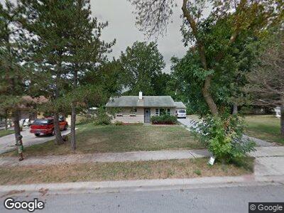
6202 Kent Rd Fort Wayne, IN 46816
Hillcrest NeighborhoodEstimated Value: $102,000 - $135,521
3
Beds
1
Bath
875
Sq Ft
$136/Sq Ft
Est. Value
About This Home
This home is located at 6202 Kent Rd, Fort Wayne, IN 46816 and is currently estimated at $119,380, approximately $136 per square foot. 6202 Kent Rd is a home located in Allen County with nearby schools including Harrison Hill Elementary School, Kekionga Middle School, and South Side High School.
Ownership History
Date
Name
Owned For
Owner Type
Purchase Details
Closed on
Jan 12, 2022
Sold by
Tes Properties Llc
Bought by
Ramirez Cesario Ortiz
Current Estimated Value
Purchase Details
Closed on
Jan 11, 2022
Sold by
Tes Properties Llc
Bought by
Ramirez Cesario Ortiz
Purchase Details
Closed on
Jan 6, 2022
Sold by
Tes Properties Llc
Bought by
Ramirez Cesario Ortiz
Purchase Details
Closed on
Apr 11, 2011
Sold by
Rister Janet
Bought by
Tes Properties Llc
Purchase Details
Closed on
Jun 17, 2004
Sold by
Hamlin Julie Ann and Jacques Julie Ann
Bought by
Rister Janet
Home Financials for this Owner
Home Financials are based on the most recent Mortgage that was taken out on this home.
Original Mortgage
$50,000
Interest Rate
8.88%
Mortgage Type
Purchase Money Mortgage
Create a Home Valuation Report for This Property
The Home Valuation Report is an in-depth analysis detailing your home's value as well as a comparison with similar homes in the area
Home Values in the Area
Average Home Value in this Area
Purchase History
| Date | Buyer | Sale Price | Title Company |
|---|---|---|---|
| Ramirez Cesario Ortiz | -- | None Listed On Document | |
| Ramirez Cesario Ortiz | $59,900 | None Available | |
| Ramirez Cesario Ortiz | $59,900 | None Listed On Document | |
| Tes Properties Llc | $15,921 | None Available | |
| Rister Janet | -- | Commonwealth-Dreibelbiss Tit |
Source: Public Records
Mortgage History
| Date | Status | Borrower | Loan Amount |
|---|---|---|---|
| Previous Owner | Rister Janet | $57,950 | |
| Previous Owner | Rister Janet | $50,000 |
Source: Public Records
Tax History Compared to Growth
Tax History
| Year | Tax Paid | Tax Assessment Tax Assessment Total Assessment is a certain percentage of the fair market value that is determined by local assessors to be the total taxable value of land and additions on the property. | Land | Improvement |
|---|---|---|---|---|
| 2024 | $587 | $99,600 | $27,700 | $71,900 |
| 2022 | $493 | $72,600 | $15,200 | $57,400 |
| 2021 | $885 | $39,500 | $6,500 | $33,000 |
| 2020 | $746 | $34,100 | $6,800 | $27,300 |
| 2019 | $730 | $33,500 | $8,500 | $25,000 |
| 2018 | $623 | $28,400 | $6,100 | $22,300 |
| 2017 | $708 | $32,000 | $7,300 | $24,700 |
| 2016 | $582 | $26,700 | $6,800 | $19,900 |
| 2014 | $447 | $21,500 | $5,000 | $16,500 |
| 2013 | $519 | $25,000 | $5,800 | $19,200 |
Source: Public Records
Map
Nearby Homes
- 6322 S Calhoun St
- 107 W Concord Ln
- 110 W Concord Ln
- 111 W Concord Ln
- 5916 S Harrison St
- 5904 S Harrison St
- 420 Southview Ave
- 408 Burns Blvd
- 5709 Hoagland Ave
- 6130 Hystone Dr
- 5645 S Wayne Ave Unit D
- 5109 Hoagland Ave
- 5521 S Wayne Ave Unit 5521
- S of 5008 Mc Clellan St
- 444 W Fairfax Ave
- 6621 Winchester Rd
- 1319 Farwood Ave
- 4820 Montrose Ave
- 1328 E Paulding Rd
- 7211 Snowfall Ct