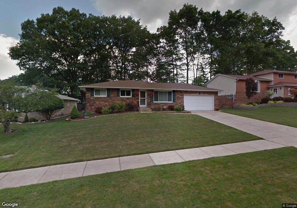
6202 Thoreau Dr Cleveland, OH 44129
Estimated Value: $257,842 - $292,000
3
Beds
2
Baths
1,308
Sq Ft
$208/Sq Ft
Est. Value
About This Home
This home is located at 6202 Thoreau Dr, Cleveland, OH 44129 and is currently estimated at $272,711, approximately $208 per square foot. 6202 Thoreau Dr is a home located in Cuyahoga County with nearby schools including Dentzler Elementary School, Normandy High School, and Hillside Middle School.
Ownership History
Date
Name
Owned For
Owner Type
Purchase Details
Closed on
Mar 15, 2003
Sold by
Dukowski Charlene M
Bought by
Corea Charles
Current Estimated Value
Home Financials for this Owner
Home Financials are based on the most recent Mortgage that was taken out on this home.
Original Mortgage
$118,000
Interest Rate
5.33%
Purchase Details
Closed on
Oct 24, 1977
Sold by
Mcbarron Robert S and F R
Bought by
Dukowski Terrance F
Purchase Details
Closed on
Jan 1, 1975
Bought by
Mcbarron Robert S and F R
Create a Home Valuation Report for This Property
The Home Valuation Report is an in-depth analysis detailing your home's value as well as a comparison with similar homes in the area
Home Values in the Area
Average Home Value in this Area
Purchase History
| Date | Buyer | Sale Price | Title Company |
|---|---|---|---|
| Corea Charles | $158,000 | Suntrust Title | |
| Dukowski Terrance F | $58,500 | -- | |
| Mcbarron Robert S | -- | -- |
Source: Public Records
Mortgage History
| Date | Status | Borrower | Loan Amount |
|---|---|---|---|
| Closed | Corea Charles | $118,000 |
Source: Public Records
Tax History Compared to Growth
Tax History
| Year | Tax Paid | Tax Assessment Tax Assessment Total Assessment is a certain percentage of the fair market value that is determined by local assessors to be the total taxable value of land and additions on the property. | Land | Improvement |
|---|---|---|---|---|
| 2024 | $4,723 | $77,700 | $15,295 | $62,405 |
| 2023 | $4,542 | $64,900 | $12,990 | $51,910 |
| 2022 | $4,503 | $64,890 | $12,990 | $51,910 |
| 2021 | $4,636 | $64,890 | $12,990 | $51,910 |
| 2020 | $4,393 | $54,530 | $10,920 | $43,610 |
| 2019 | $4,229 | $155,800 | $31,200 | $124,600 |
| 2018 | $4,252 | $54,530 | $10,920 | $43,610 |
| 2017 | $4,026 | $48,130 | $9,520 | $38,610 |
| 2016 | $3,655 | $43,580 | $9,520 | $34,060 |
| 2015 | $3,597 | $43,580 | $9,520 | $34,060 |
| 2014 | $3,597 | $44,940 | $9,800 | $35,140 |
Source: Public Records
Map
Nearby Homes
- 6417 Thoreau Dr
- 5810 Ely Vista Dr
- 5602 Ely Vista Dr
- 6862 Talbot Dr
- 6882 Day Dr
- 7580 S Pointe Ln
- 7596 S Pointe Ln
- 7351 S Pointe Ln
- Rosecliff Plan at South Pointe - Townhomes
- Caroline Plan at South Pointe - Townhomes
- 4803 Sassafras Dr
- 6813 Rolling Meadow Dr
- 8305 Banner Ln
- 8406 Fenway Dr
- 8375 Royal Ridge Dr
- 7531 Vista Dr
- 7272 Normandy Dr
- 4402 Stary Dr
- 5208 Orchard Park Dr
- 8584 Newcomb Dr
- 6212 Thoreau Dr
- 6201 Night Vista Dr
- 6104 Thoreau Dr
- 6209 Night Vista Dr
- 6111 Night Vista Dr
- 7201 Antoinette Dr
- 6201 Thoreau Dr
- 6103 Night Vista Dr
- 6115 Thoreau Dr
- 6010 Thoreau Dr
- 6308 Thoreau Dr
- 7205 Antoinette Dr
- 6307 Night Vista Dr
- 6103 Thoreau Dr
- 6015 Night Vista Dr
- 6002 Thoreau Dr
- 6009 Thoreau Dr
- 6309 Thoreau Dr
- 6401 Night Vista Dr
- 7209 Antoinette Dr