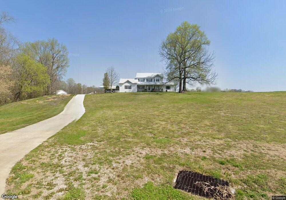
621 New Bushy Branch Rd Manchester, TN 37355
Estimated Value: $505,000 - $2,784,000
--
Bed
4
Baths
2,736
Sq Ft
$685/Sq Ft
Est. Value
About This Home
This home is located at 621 New Bushy Branch Rd, Manchester, TN 37355 and is currently estimated at $1,872,795, approximately $684 per square foot. 621 New Bushy Branch Rd is a home located in Coffee County with nearby schools including East Coffee Elementary School, Coffee County Middle School, and Coffee County Central High School.
Ownership History
Date
Name
Owned For
Owner Type
Purchase Details
Closed on
Jun 5, 2024
Sold by
Samuel Mcallister Trust
Bought by
Howard I A I and Howard Marilyn J
Current Estimated Value
Purchase Details
Closed on
Nov 26, 2013
Sold by
Mcallister Samuel
Bought by
Mcallister Samuel Trust
Purchase Details
Closed on
Aug 21, 2003
Sold by
Hale Billy H and Hale Nancy G
Bought by
Mcallister Samuel
Purchase Details
Closed on
May 18, 1993
Bought by
Mcallister Samuel
Create a Home Valuation Report for This Property
The Home Valuation Report is an in-depth analysis detailing your home's value as well as a comparison with similar homes in the area
Home Values in the Area
Average Home Value in this Area
Purchase History
| Date | Buyer | Sale Price | Title Company |
|---|---|---|---|
| Howard I A I | $2,500,000 | Bell & Alexander Title Service | |
| Mcallister Samuel Trust | -- | -- | |
| Mcallister Samuel | $42,400 | -- | |
| Mcallister Samuel | $1,330,600 | -- |
Source: Public Records
Tax History Compared to Growth
Tax History
| Year | Tax Paid | Tax Assessment Tax Assessment Total Assessment is a certain percentage of the fair market value that is determined by local assessors to be the total taxable value of land and additions on the property. | Land | Improvement |
|---|---|---|---|---|
| 2024 | $3,408 | $146,200 | $60,925 | $85,275 |
| 2023 | $3,408 | $146,200 | $0 | $0 |
| 2022 | $3,408 | $146,200 | $60,925 | $85,275 |
| 2021 | $3,387 | $115,500 | $48,725 | $66,775 |
| 2020 | $3,387 | $115,500 | $48,725 | $66,775 |
| 2019 | $3,387 | $115,500 | $48,725 | $66,775 |
| 2018 | $3,387 | $115,500 | $48,725 | $66,775 |
| 2017 | $3,371 | $103,300 | $45,000 | $58,300 |
| 2016 | $3,191 | $97,800 | $45,000 | $52,800 |
| 2015 | $3,191 | $97,800 | $45,000 | $52,800 |
| 2014 | $3,191 | $97,805 | $0 | $0 |
Source: Public Records
Map
Nearby Homes
- 793 Old Bushy Branch Rd
- 416 Powers Rd
- 775 Ragsdale Rd
- 627 Ragsdale Rd
- 107 Grace Ct
- 515 Mckellar Dr
- 215 Wellington Dr
- 602 Johnson St
- 537 Shelton Rd
- 608 Henley St
- 1395 Ragsdale Rd
- 605 Johnson St
- 1292 McMinnville Hwy
- 390 Oak Hollow Rd
- 1203 Woodland Dr
- 412 E Harp St
- 1610 Summer St
- 1005 Thoma St
- 1014 Hills Chapel Rd
- 223 Duck River Rd
- 93 Powers Rd
- 152 Powers Rd
- 786 New Bushy Branch Rd
- 261 Swing Away Dr
- 289 Swing Away Dr
- 849 Old Bushy Branch Rd
- 87 Baker St
- 313 Swing Away Dr
- 861 Old Bushy Branch Rd
- 69 Baker St
- 835 Old Bushy Branch Rd
- 890 Old Bushy Branch Rd
- 86 Baker St
- 51 Baker St
- 230 Swing Away Dr
- 815 Old Bushy Branch Rd
- 535 Old Bushy Branch Rd
- 68 Baker St
- 312 Swing Away Dr
- 218 Powers Rd